| [3] |
Name on the Register[4] |
Image |
Date listed[5] |
Location |
City or town |
Description |
|---|
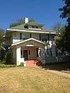
| 1 |
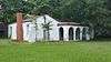
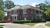
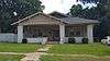
Abercrombie-Cavanaugh House |
|
000000001988-12-22-0000December 22, 1988
(#88002794) |
304 Paul Ave.
31°20′31″N 94°43′30″W / 31.341944°N 94.725°W / 31.341944; -94.725 (Abercrombie-Cavanaugh House) |
Lufkin |
|
| 2 |
Angelina River Bridge |
Upload image |
000000001988-12-22-0000December 22, 1988
(#88002801) |
US 59 over Angelina River
31°27′25″N 94°43′34″W / 31.456944°N 94.726111°W / 31.456944; -94.726111 (Angelina River Bridge) |
Lufkin |
Bridge replaced 1998[6]
|
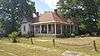
| 3 |
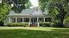
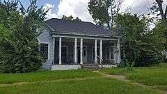
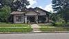
Banks-Ogg House |
|
000000001988-12-22-0000December 22, 1988
(#88002771) |
602 E Groesbeck St.
31°20′21″N 94°43′21″W / 31.339167°N 94.7225°W / 31.339167; -94.7225 (Banks-Ogg House) |
Lufkin |
|
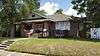
| 4 |
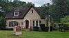
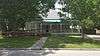
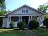
Behannon-Kenley House |
|
000000001988-12-22-0000December 22, 1988
(#88002798) |
317 Shepherd Ave.
31°20′15″N 94°43′34″W / 31.33747°N 94.72614°W / 31.33747; -94.72614 (Behannon-Kenley House) |
Lufkin |
|
| 5 |
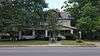
Binion-Casper House |
|
000000001989-07-19-0000July 19, 1989
(#88002785) |
404 Mantooth Ave.
31°20′30″N 94°44′00″W / 31.34169°N 94.73329°W / 31.34169; -94.73329 (Binion-Casper House) |
Lufkin |
|
| 6 |
Bowers-Felts House |
|
000000001988-12-22-0000December 22, 1988
(#88002780) |
1213 Lotus Ln.
31°20′27″N 94°44′42″W / 31.340833°N 94.745°W / 31.340833; -94.745 (Bowers-Felts House) |
Lufkin |
|
| 7 |
Boynton-Kent House |
|
000000001988-12-22-0000December 22, 1988
(#88002779) |
107 W Kerr St.
31°19′52″N 94°43′46″W / 31.33100°N 94.72936°W / 31.33100; -94.72936 (Boynton-Kent House) |
Lufkin |
|
| 8 |
Houston Brookshire-Yeates House |
|
000000001988-12-22-0000December 22, 1988
(#88002776) |
304 E Howe St.
31°20′34″N 94°43′28″W / 31.342778°N 94.724444°W / 31.342778; -94.724444 (Houston Brookshire-Yeates House) |
Lufkin |
|
| 9 |
Byus-Kirkland House |
|
000000001988-12-22-0000December 22, 1988
(#88002786) |
411 Mantooth Ave.
31°20′27″N 94°44′00″W / 31.340833°N 94.733333°W / 31.340833; -94.733333 (Byus-Kirkland House) |
Lufkin |
|
| 10 |
Clark-Whitton House |
|
000000001988-12-22-0000December 22, 1988
(#88002792) |
1865 Old Mill Rd.
31°21′30″N 94°44′57″W / 31.35844°N 94.74918°W / 31.35844; -94.74918 (Clark-Whitton House) |
Lufkin |
|
| 11 |
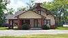
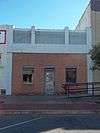
Corstone Sales Company |
|
000000001988-12-22-0000December 22, 1988
(#88002797) |
109-111 E Shepherd St.
31°20′17″N 94°43′43″W / 31.338056°N 94.728611°W / 31.338056; -94.728611 (Corstone Sales Company) |
Lufkin |
|
| 12 |
Dunham Hill |
Upload image |
000000001988-12-22-0000December 22, 1988
(#88002803) |
US 69 west of Huntington
31°17′03″N 94°35′41″W / 31.28423°N 94.5946°W / 31.28423; -94.5946 (Dunham Hill) |
Huntington |
|
| 13 |
Everitt-Cox House |
|
000000001988-12-22-0000December 22, 1988
(#88002789) |
418 Moore Ave.
31°20′23″N 94°43′59″W / 31.33959°N 94.73298°W / 31.33959; -94.73298 (Everitt-Cox House) |
Lufkin |
|
| 14 |
Fenley Commercial Building |
|
000000001988-12-22-0000December 22, 1988
(#88002781) |
112 E Lufkin Ave.
31°20′20″N 94°43′42″W / 31.338889°N 94.728333°W / 31.338889; -94.728333 (Fenley Commercial Building) |
Lufkin |
|
| 15 |
Gibbs-Flournoy House |
Upload image |
000000001988-12-22-0000December 22, 1988
(#88002804) |
Farm to Market Road 844
31°08′30″N 94°32′26″W / 31.141667°N 94.540556°W / 31.141667; -94.540556 (Gibbs-Flournoy House) |
Manning |
|
| 16 |
S. W. Henderson-Bridges House |
Upload image |
000000001988-12-22-0000December 22, 1988
(#88002775) |
202 Henderson St.
31°21′36″N 94°45′05″W / 31.36004°N 94.75128°W / 31.36004; -94.75128 (S. W. Henderson-Bridges House) |
Lufkin |
|
| 17 |
Humason-Pinkerton House |
|
000000001988-12-22-0000December 22, 1988
(#88002773) |
602 Grove Ave.
31°20′33″N 94°44′01″W / 31.3425°N 94.733611°W / 31.3425; -94.733611 (Humason-Pinkerton House) |
Lufkin |
|
| 18 |
Keltys Worker Housing |
|
000000001988-12-22-0000December 22, 1988
(#88002784) |
109 Maas
31°21′38″N 94°45′10″W / 31.36060°N 94.75271°W / 31.36060; -94.75271 (Keltys Worker Housing) |
Lufkin |
|
| 19 |
A. C. Kennedy-Runnells House |
|
000000001988-12-22-0000December 22, 1988
(#88002772) |
603 E Groesbeck St.
31°20′23″N 94°43′20″W / 31.339722°N 94.722222°W / 31.339722; -94.722222 (A. C. Kennedy-Runnells House) |
Lufkin |
|
| 20 |
R. A. Kennedy-J. M. Lowrey House |
|
000000001988-12-22-0000December 22, 1988
(#88002770) |
519 E Groesbeck St.
31°20′23″N 94°43′22″W / 31.339722°N 94.722778°W / 31.339722; -94.722778 (R. A. Kennedy-J. M. Lowrey House) |
Lufkin |
|
| 21 |
J. H. Kurth House |
|
000000001988-12-22-0000December 22, 1988
(#88002791) |
1860 Old Mill Rd.
31°21′30″N 94°44′53″W / 31.35844°N 94.74812°W / 31.35844; -94.74812 (J. H. Kurth House) |
Lufkin |
|
| 22 |
Kurth-Glover House |
|
000000001988-12-22-0000December 22, 1988
(#88002790) |
1847 Old Mill Rd.
31°21′26″N 94°44′55″W / 31.35717°N 94.74865°W / 31.35717; -94.74865 (Kurth-Glover House) |
Lufkin |
|
| 23 |
G. E. Lawrence House |
|
000000001988-12-22-0000December 22, 1988
(#88002766) |
2005 S Chestnut St.
31°18′48″N 94°42′30″W / 31.313333°N 94.708333°W / 31.313333; -94.708333 (G. E. Lawrence House) |
Lufkin |
|
| 24 |
Lufkin Land-Long Bell-Buck House |
|
000000001988-12-22-0000December 22, 1988
(#88002783) |
1218 Lufkin St.
31°20′10″N 94°42′59″W / 31.336111°N 94.716389°W / 31.336111; -94.716389 (Lufkin Land-Long Bell-Buck House) |
Lufkin |
|
| 25 |
Marsh-Smith House |
|
000000001988-12-22-0000December 22, 1988
(#88002796) |
503 N Raguet St.
31°20′30″N 94°44′08″W / 31.341667°N 94.735556°W / 31.341667; -94.735556 (Marsh-Smith House) |
Lufkin |
|
| 26 |
McClendon-Abney Hardware Company |
|
000000001988-12-22-0000December 22, 1988
(#88002782) |
119 E Lufkin Ave.
31°20′20″N 94°43′41″W / 31.338889°N 94.728056°W / 31.338889; -94.728056 (McClendon-Abney Hardware Company) |
Lufkin |
|
| 27 |
McGilbert House |
Upload image |
000000001988-12-22-0000December 22, 1988
(#88002793) |
1902 Old Mill Rd.
31°21′30″N 94°44′53″W / 31.358397°N 94.748075°W / 31.358397; -94.748075 (McGilbert House) |
Lufkin |
|
| 28 |
Newsom-Moss House |
|
000000001988-12-22-0000December 22, 1988
(#88002787) |
420 Mantooth Ave.
31°20′29″N 94°44′02″W / 31.341389°N 94.733889°W / 31.341389; -94.733889 (Newsom-Moss House) |
Lufkin |
|
| 29 |
Old Federal Building-Federal Courthouse |
|
000000001988-12-22-0000December 22, 1988
(#88002799) |
104 N Third St.
31°20′19″N 94°43′34″W / 31.338611°N 94.726111°W / 31.338611; -94.726111 (Old Federal Building-Federal Courthouse) |
Lufkin |
|
| 30 |
Parker-Bradshaw House |
|
000000001988-12-22-0000December 22, 1988
(#88002795) |
213 N Raguet St.
31°20′22″N 94°44′05″W / 31.339444°N 94.734722°W / 31.339444; -94.734722 (Parker-Bradshaw House) |
Lufkin |
|
| 31 |
Dr. Edward Percy-Abney House |
|
000000001988-12-22-0000December 22, 1988
(#88002778) |
466 Jefferson Ave.
31°20′06″N 94°44′09″W / 31.335°N 94.735833°W / 31.335; -94.735833 (Dr. Edward Percy-Abney House) |
Lufkin |
|
| 32 |
A. F. Perry and Myrtle-Pitmann House |
|
000000001988-12-22-0000December 22, 1988
(#88002765) |
402 S Bynum St.
31°20′01″N 94°44′16″W / 31.333611°N 94.737778°W / 31.333611; -94.737778 (A. F. Perry and Myrtle-Pitmann House) |
Lufkin |
|
| 33 |
C. W. Perry Archie-Hallmark House |
|
000000001988-12-22-0000December 22, 1988
(#88002764) |
302 S. Bynum
31°20′04″N 94°44′18″W / 31.334444°N 94.738333°W / 31.334444; -94.738333 (C. W. Perry Archie-Hallmark House) |
Lufkin |
|
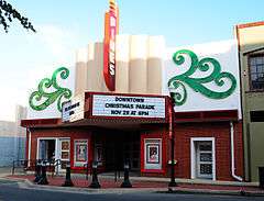
| 34 |
Pines Theatre |
|
000000001988-12-22-0000December 22, 1988
(#88002767) |
113 S First St.
31°20′18″N 94°43′44″W / 31.33845°N 94.72883°W / 31.33845; -94.72883 (Pines Theatre) |
Lufkin |
|
| 35 |
Rastus-Read House |
Upload image |
000000001988-12-22-0000December 22, 1988
(#88002768) |
1509 S First St.
31°19′12″N 94°43′38″W / 31.32°N 94.727222°W / 31.32; -94.727222 (Rastus-Read House) |
Lufkin |
Demolished
|
| 36 |
Russell-Arnold House |
Upload image |
000000001988-12-22-0000December 22, 1988
(#88002788) |
121 W Menefee St.
31°19′38″N 94°43′43″W / 31.327222°N 94.728611°W / 31.327222; -94.728611 (Russell-Arnold House) |
Lufkin |
Demolished
|
| 37 |
Standley House |
Upload image |
000000001988-12-22-0000December 22, 1988
(#88002800) |
1607 Tulane Dr.
31°19′01″N 94°43′23″W / 31.316944°N 94.723056°W / 31.316944; -94.723056 (Standley House) |
Lufkin |
Demolished
|
| 38 |
Henry G. Temple House |
Upload image |
000000001988-12-22-0000December 22, 1988
(#88002802) |
501 Hines Rd.
31°10′40″N 94°47′16″W / 31.177778°N 94.787778°W / 31.177778; -94.787778 (Henry G. Temple House) |
Diboll |
|
| 39 |
Texas Highway Department Complex |
|
000000001988-12-22-0000December 22, 1988
(#88002769) |
110 Forest Park
31°21′26″N 94°43′02″W / 31.35710°N 94.71729°W / 31.35710; -94.71729 (Texas Highway Department Complex) |
Lufkin |
Consists of 6 buildings
|
| 40 |
Walter C. Trout-White House |
|
000000001988-12-22-0000December 22, 1988
(#88002777) |
444 Jefferson Ave.
31°20′08″N 94°44′04″W / 31.335556°N 94.734444°W / 31.335556; -94.734444 (Walter C. Trout-White House) |
Lufkin |
|
| 41 |
Howard Walker House |
Upload image |
000000001988-12-22-0000December 22, 1988
(#88002774) |
503 Harmony Hill Rd.
31°18′32″N 94°43′13″W / 31.308889°N 94.720278°W / 31.308889; -94.720278 (Howard Walker House) |
Lufkin |
|
.jpg)


.jpg)


.jpg)
.jpg)


.jpg)