Nasipit, Agusan del Norte
| Nasipit | |||
|---|---|---|---|
| Municipality | |||
|
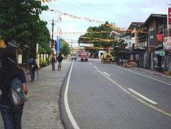
Downtown Nasipit | |||
| |||
 Location within Agusan del Norte province | |||
.svg.png) Nasipit Location within the Philippines | |||
| Coordinates: 8°59′N 125°20′E / 8.99°N 125.34°ECoordinates: 8°59′N 125°20′E / 8.99°N 125.34°E | |||
| Country | Philippines | ||
| Region | Caraga (Region XIII) | ||
| Province | Agusan del Norte | ||
| District | 2nd District of ADN | ||
| Municipality | August 1, 1929 | ||
| Barangays | 19 (see Barangays) | ||
| Government [1] | |||
| • Type | Sangguniang Bayan | ||
| • Mayor | Enrico R. Corvera | ||
| • Vice Mayor | Dick Victor B. Carmona | ||
| • Congressman | Erlpe John M. Amante | ||
| Area[2] | |||
| • Total | 144.4 km2 (55.8 sq mi) | ||
| Population (2015 census)[3] | |||
| • Total | 41,957 | ||
| • Density | 290/km2 (750/sq mi) | ||
| • Voter (2016)[4] | 25,926 | ||
| Time zone | PST (UTC+8) | ||
| ZIP code | 8602 | ||
| IDD : area code | +63 (0)85 | ||
| Income class | 3rd class | ||
| PSGC | 160209000 | ||
| Languages | |||
| Website |
www | ||


Nasipit, officially the Municipality of Nasipit (Filipino: Bayan ng Nasipit), is a municipality in the province of Agusan del Norte in the Caraga (Region XIII) of the Philippines. The population was 41,957 at the 2015 census.[3] In the 2016 election, it had 25,926 registered voters.[4]
The Port of Nasipit is the major seaport or base port in Agusan del Norte. The Philippine Ports Authority (PPA) assigned PMO Nasipit as an International Base port.[5]
History
The recorded history of Nasipit can be traced back to as early as 1880s when it was declared as a pueblo by the Spanish colonizers. According to townsfolk, its name may have been derived from an incident where a native, immediately after being bitten by a crab, was asked the name of the place by an immigrant. Misunderstanding the question, the native answered na-si-pit meaning "bitten by a crab". Since then, the town became known as Nasipit.
Nasipit was officially separated from the municipality of Butuan on August 1, 1929. It became a municipality by virtue of Executive Order No. 181 issued by Acting Governor General of the Philippines Eugene Allen Gilmore. A proposal to change its name to Aurora was initiated by former Governor Teofisto Guingona Sr., but due to the strong opposition from townsfolk, the name Nasipit was retained.
In 1949, the barrios of Carmen, Tagcatong, Cahayagan and San Agustin were separated from Nasipit and constituted into the new town of Carmen by virtue of Republic Act No. 380 which was approved on June 15, 1949.[6]
Geography
Nasipit is located at 8°59′N 125°20′E / 8.99°N 125.34°E.
According to the Philippine Statistics Authority, the municipality has a land area of 144.4 square kilometres (55.8 sq mi)[2] constituting 5.29% of the 2,730.24-square-kilometre- (1,054.15 sq mi) total area of Agusan del Norte.
Nasipit occupies the north-western portion of the province. It is bounded in the east and south by Buenavista, west by Carmen, and north by the Butuan Bay. It is 24 kilometres (15 mi) west of Butuan and 175 kilometres (109 mi) north-east of Cagayan de Oro. The town is accessible by sea through the inter-island vessels docking in the Nasipit International Seaport, to destinations such as Manila, Cebu, Bohol, and Cagayan de Oro.
Barangays
Nasipit is politically subdivided into 19 barangays.[7] Of these, 5 are urban and 14 are rural.[7] Of the 19 barangays, 9 are coastal: Cubi–Cubi, Ata–Atahon, Punta, Barangay 1 Apagan (Poblacion), Talisay (home to the Port of Nasipit), Santa Ana, Camagong, Amontay and Aclan.
| PSGC | Barangay | Population | ±% p.a. | ||
|---|---|---|---|---|---|
| 2015[3] | 2010[8] | ||||
| 160209001 | Aclan | 5.6% | 2,354 | 2,217 | +1.15% |
| 160209002 | Amontay | 4.4% | 1,840 | 1,658 | +2.00% |
| 160209004 | Ata-atahon | 4.3% | 1,820 | 1,614 | +2.31% |
| 160209010 | Barangay 1 (Poblacion) | 2.6% | 1,108 | 1,159 | −0.85% |
| 160209011 | Barangay 2 (Poblacion) | 2.9% | 1,197 | 1,216 | −0.30% |
| 160209012 | Barangay 3 (Poblacion) | 2.0% | 841 | 969 | −2.66% |
| 160209013 | Barangay 4 (Poblacion) | 1.7% | 731 | 822 | −2.21% |
| 160209014 | Barangay 5 (Poblacion) | 3.0% | 1,270 | 1,506 | −3.19% |
| 160209015 | Barangay 6 (Poblacion) | 3.1% | 1,319 | 1,466 | −1.99% |
| 160209016 | Barangay 7 (Poblacion) | 4.7% | 1,976 | 1,636 | +3.66% |
| 160209005 | Camagong | 12.4% | 5,204 | 4,917 | +1.09% |
| 160209006 | Cubi-Cubi | 3.2% | 1,338 | 1,291 | +0.68% |
| 160209007 | Culit | 7.2% | 3,039 | 3,074 | −0.22% |
| 160209008 | Jaguimitan | 3.9% | 1,647 | 1,374 | +3.51% |
| 160209009 | Kinabjangan | 8.9% | 3,714 | 3,591 | +0.64% |
| 160209017 | Punta | 8.8% | 3,685 | 3,613 | +0.38% |
| 160209018 | Santa Ana | 5.5% | 2,307 | 2,110 | +1.71% |
| 160209019 | Talisay | 8.9% | 3,729 | 3,668 | +0.31% |
| 160209020 | Triangulo | 6.8% | 2,838 | 2,762 | +0.52% |
| Total | 41,957 | 40,663 | +0.60% | ||
Demographics
| Population census of Nasipit | |||||||||||||||||||||||||
|---|---|---|---|---|---|---|---|---|---|---|---|---|---|---|---|---|---|---|---|---|---|---|---|---|---|
|
| ||||||||||||||||||||||||
| Source: PSA[3][8][9] | |||||||||||||||||||||||||
In the 2015 census, Nasipit had a population of 41,957.[3] The population density was 290 inhabitants per square kilometre (750/sq mi).
In the 2016 election, it had 25,926 registered voters.[4]
Economy
Nasipit was identified by the Caraga Regional Development Council (Caraga RDC) through Resolution Number 44 Series of 1996, as the Regional Agri-Industrial Growth Center (RAGC) of the Caraga Region. The municipality's identification as the RAGC and its inclusion in the Agusan Norte Special Economic Zone (ANSEZ) can be attributed to the establishment of the Nasipit Agusan del Norte Industrial Estate (NANIE). Covering a total of 296.9 hectares (734 acres) and located within barangays Camagong and Talisay, the proposed estate is envisaged to be an industrial nucleus or manufacturing center in the province where industrial plants, bonded warehouses, container yards and other industrial facilities will be located and made available to investors.
Attractions

Nasipit celebrates its annual fiesta every 29 September in honor to the town’s patron saint, St. Michael, the Archangel, which includes thanksgiving mass and parade before the day of fiesta activities.
Araw ng Nasipit (Day of Nasipit) - the day commemorating the townhood anniversary of Nasipit from 1929 after it was a barrio of Butuan
Located at the heart of the town, it was built by MSC or Dutch Priests during 60’s. Recently, the altar of the church was constructed on its new image.
Transportation
Nasipit can be accessed through the Mindanao Pan-Philippine Highway.
Air
- Bancasi Airport of Butuan
- Laguindingan Airport of Cagayan de Oro
PAL and Cebu Pacific have daily flights from Manila to Butuan and vice versa.

Sea
Through the Port of Nasipit, there are several major shipping lines serving the Manila and Cebu routes: 2GO Travel, Carlos A. Gothong Shipping Lines, Philippine Span Asia Carrier Corporation aka Sulpicio Lines, Cokaliong Shipping Lines Inc., and Trans-Asia Shipping Lines. The Philippine Coast Guard — CG Detachment Nasipit is located at the Port of Nasipit near the Nasipit SeaPort Terminal.
Land
Nasipit can be reached by riding jeepney, van, multicabs and buses from Butuan in 45 minutes, and 4 hours to 5 hours by bus from Cagayan de Oro. The public mode of transportation in Nasipit is by tricycle similar in Butuan.
Education
- Aclan Elementary School
- Amontay Elementary School
- Ata-Atahon Elementary School
- Camagong Elementary School
- Cubi-Cubi Elementary School
- Culit Elementary School
- Jaguimitan Elementary School
- Kinabjangan Central Elementary School - East Central
- Nasipit Central Elementary School - West Central
- Northwestern Agusan Colleges
- Punta Elementary School
- Saint Michael College of Caraga
- Santa Ana Elementary School
- Talisay Elementary School
- Triangulo Elementary School
- Saint Michael College of Caraga
- Ata-atahon National High School
- Culit National High School
- Jaguimitan National High School
- Liceo de Agusan
- Nasipit Institute
- Nasipit Institute of Technology
- Nasipit National High School (NNHS/IS)
- Nasipit National Vocational School
- Northwestern Agusan Colleges
- Pacifican Institute of Agusan
- Virginia Institute of Technology
References
- ↑ "Municipality". Quezon City, Philippines: Department of the Interior and Local Government. Retrieved 31 May 2013.
- 1 2 "Province: Agusan del Norte". PSGC Interactive. Makati City, Philippines: Philippine Statistics Authority. Retrieved 28 October 2016.
- 1 2 3 4 5 "CARAGA". Census of Population (2015): Total Population by Province, City, Municipality and Barangay (Report). PSA. Retrieved 20 June 2016.
- 1 2 3 "2016 National and Local Elections Statistics". Commission on Elections. 2016.
- ↑ http://www.ppa.com.ph/
- ↑ "Republic Act No. 380 - Act Creating the Municipality of Carmen in the Province of Agusan". PhilippineLaw.info. 15 June 1949. Archived from the original on 31 May 2012. Retrieved 16 October 2016.
- 1 2 "Municipal: Nasipit, Agusan del Norte". PSGC Interactive. Quezon City, Philippines: Philippine Statistics Authority. Retrieved 8 January 2016.
- 1 2 "CARAGA". Census of Population and Housing (2010): Total Population by Province, City, Municipality and Barangay (Report). NSO. Retrieved 29 June 2016.
- ↑ "CARAGA". Census of Population (1995, 2000 and 2007): Total Population by Province, City and Municipality (Report). NSO. Archived from the original on 11 November 2011.
External links
| Wikimedia Commons has media related to Nasipit, Agusan del Norte. |
 |
Butuan Bay | | ||
| Carmen | |
Buenavista | ||
| ||||
| | ||||
| Buenavista |
Cabadbaran (capital) | |
| Municipalities | |
| Component city | |
| Highly urbanized city |
|