Naryn
| Naryn | ||
|---|---|---|
|
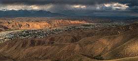
Overlook of Naryn from the south | ||
| ||
 Naryn Location in Kyrgyzstan | ||
| Coordinates: 41°26′N 76°0′E / 41.433°N 76.000°ECoordinates: 41°26′N 76°0′E / 41.433°N 76.000°E | ||
| Country |
| |
| Region | Naryn Region | |
| Area | ||
| • Total | 40.51 km2 (15.64 sq mi) | |
| Elevation | 2,044 m (6,706 ft) | |
| Population (2009)[1] | ||
| • Total | 34,822 | |
| • Density | 860/km2 (2,200/sq mi) | |
| de jure population | ||
| Time zone | KGT (UTC+6) | |
| 722900 | 722600 | |
| Area code(s) | 722600 | |

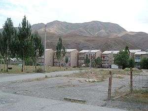
Naryn (Kyrgyz: Нарын, Narın, نارىن) is the regional administrative center of Naryn Region in central Kyrgyzstan, with a population of 34,822 (2009 Census). It is situated on both banks of the Naryn River (one of the main head waters of the Syr Darya), which cuts a picturesque gorge through the town. The city has two regional museums and some hotels, but is otherwise residential.
Overview
From Naryn, the main road (one of the branches of the ancient Silk Road) runs south through the sparsely settled central Kyrgyz highlands to the Torugart Pass and China. At present, this is the main transport link from Kyrgyzstan to China. Naryn hosts one of three campuses of the University of Central Asia (UCA). The University was founded in 2000 by the governments of Kazakhstan, the Kyrgyz Republic and Tajikistan, and His Highness the Aga Khan. It is the world’s first internationally chartered institution of higher education. The UCA currently operates a School of Professional and Continuing Education (SPCE), with a School of Undergraduate Studies and a Graduate School of Development in the process of being established. Undergraduate classes at the University of Central Asia’s (UCA) Naryn, Kyrgyz Republic campus commenced on 5 September 2016.[2]
Demographics
Naryn is the tenth largest city by population in Kyrgyzstan. Its de facto population, according to the Population and Housing Census of 2009, was 34,226.
| Historical populations in Naryn | ||
|---|---|---|
| Year | Pop. | ±% |
| 1926 | 1,632 | — |
| 1959 | 6,033 | +269.7% |
| 1970 | 21,098 | +249.7% |
| 1979 | 30,409 | +44.1% |
| 1989 | 42,709 | +40.4% |
| 1999 | 40,429 | −5.3% |
| 2009 | 34,226 | −15.3% |
| Source:[4] [5][1] | ||
Climate
Naryn has a cold semi-arid climate with strong continental tendencies.
| Climate data for Naryn (1961–1990) | |||||||||||||
|---|---|---|---|---|---|---|---|---|---|---|---|---|---|
| Month | Jan | Feb | Mar | Apr | May | Jun | Jul | Aug | Sep | Oct | Nov | Dec | Year |
| Record high °C (°F) | 2 (36) |
2 (36) |
20 (68) |
27 (81) |
28 (82) |
31 (88) |
30 (86) |
34 (93) |
28 (82) |
22 (72) |
10 (50) |
0 (32) |
34 (93) |
| Average high °C (°F) | −9.7 (14.5) |
−6.6 (20.1) |
2.9 (37.2) |
13.9 (57) |
17.9 (64.2) |
21.5 (70.7) |
24.5 (76.1) |
24.9 (76.8) |
20.2 (68.4) |
12.7 (54.9) |
2.2 (36) |
−6.4 (20.5) |
9.9 (49.8) |
| Daily mean °C (°F) | −15.8 (3.6) |
−12.5 (9.5) |
−2.5 (27.5) |
7.7 (45.9) |
11.6 (52.9) |
14.7 (58.5) |
17.3 (63.1) |
17.6 (63.7) |
12.9 (55.2) |
6.0 (42.8) |
−3.5 (25.7) |
−11.9 (10.6) |
3.5 (38.3) |
| Average low °C (°F) | −20.4 (−4.7) |
−17.3 (0.9) |
−6.5 (20.3) |
2.3 (36.1) |
6.1 (43) |
8.5 (47.3) |
10.7 (51.3) |
10.4 (50.7) |
6.2 (43.2) |
0.6 (33.1) |
−7.6 (18.3) |
−16.1 (3) |
−1.9 (28.6) |
| Record low °C (°F) | −36 (−33) |
−28 (−18) |
−24 (−11) |
−8 (18) |
−1 (30) |
2 (36) |
4 (39) |
2 (36) |
−7 (19) |
−11 (12) |
−26 (−15) |
−33 (−27) |
−36 (−33) |
| Average precipitation mm (inches) | 9.7 (0.382) |
13.4 (0.528) |
19.8 (0.78) |
34.0 (1.339) |
48.5 (1.909) |
54.8 (2.157) |
37.3 (1.469) |
20.8 (0.819) |
17.3 (0.681) |
15.1 (0.594) |
10.9 (0.429) |
9.5 (0.374) |
291.1 (11.461) |
| Average precipitation days (≥ 1.0 mm) | 3.1 | 5.8 | 5.6 | 6.8 | 9.4 | 10.0 | 7.2 | 4.4 | 3.3 | 3.3 | 3.3 | 2.7 | 62.9 |
| Average relative humidity (%) | 76 | 74 | 71 | 60 | 54 | 57 | 55 | 50 | 45 | 52 | 63 | 74 | 61 |
| Mean monthly sunshine hours | 135 | 145 | 178 | 210 | 246 | 292 | 320 | 316 | 274 | 218 | 156 | 122 | 2,612 |
| Source #1: Deutscher Wetterdienst[6] | |||||||||||||
| Source #2: NOAA (sun, 1961–1990)[7] | |||||||||||||

References
- 1 2 Population and Housing Census 2009. Book 3 (in tables). Regions of Kyrgyzstan: Naryn Region (Перепись населения и жилищного фонда Кыргызской Республики 2009. Книга 3 (в таблицах). Регионы Кыргызстана: Нарынская область (PDF), Bishkek: National Committee on Statistics, 2010
- ↑ "Classes Begin for the University of Central Asia's First Undergraduate Students". University of Central Asia. Retrieved 10 October 2016.
- ↑ Info on www.canadabandy.ca
- ↑ "Всесоюзная перепись населения 1926 года : Киргизская АССР. (All-Union Census of 1926: Kyrgyz ASSR)". Moscow: CSU SSSR. 1928.
- ↑ Всесоюзная перепись населения 1959 г. All Union Census of 1959. (Demoscope.ru) (Russian)
- ↑ "Klimatafel von Naryn (Narynskoje) / Kirgisistan" (PDF). Baseline climate means (1961-1990) from stations all over the world (in German). Deutscher Wetterdienst. Retrieved 18 February 2016.
- ↑ "Naryn (MTN STN) Climate Normals 1961–1990". National Oceanic and Atmospheric Administration. Retrieved 18 February 2016.
External links
![]() Media related to Naryn at Wikimedia Commons
Media related to Naryn at Wikimedia Commons
- Celestial Mountains Travel Encyclopedia of Kyrgyzstan [English]
- Naryn Photo Gallery [English]
- Photos from Naryn [English]
Administrative seats of the regions of Kyrgyzstan | |||
|---|---|---|---|