Nanda Devi
| Nanda Devi | |
|---|---|
 | |
| Highest point | |
| Elevation |
7,816 m (25,643 ft) [1] Ranked 23rd |
| Prominence |
3,139 m (10,299 ft) [1] Ranked 74th |
| Isolation | 389 kilometres (242 mi) |
| Listing |
Ultra List of Indian states and territories by highest point |
| Coordinates | 30°32′33″N 79°58′15″E / 30.54250°N 79.97083°ECoordinates: 30°32′33″N 79°58′15″E / 30.54250°N 79.97083°E [1][2] |
| Geography | |
 Nanda Devi Location in India | |
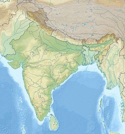
| Location | Chamoli District, Uttarakhand, India |
| Parent range | Garhwal Himalayas |
| Climbing | |
| First ascent | 29 August 1936 by Noel Odell and Bill Tilman[3][4] |
| Easiest route | south ridge: technical rock/snow/ice climb |
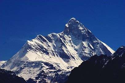
Nanda Devi is the second highest mountain in India, and the highest located entirely within the country. (Kangchenjunga, which is higher, is on the border of India and Nepal.) It is the 23rd-highest peak in the world. It was considered the highest mountain in the world before computations in 1808 proved Dhaulagiri to be higher. It was also the highest mountain in India before 1971 when Sikkim, the state in which Kangchenjunga is located, joined the Republic of India. It is part of the Garhwal Himalayas, and is located in the state of Uttarakhand, between the Rishiganga valley on the west and the Goriganga valley on the east. The peak, whose name means "Bliss-Giving Goddess",[4] is regarded as the patron-goddess of the Uttarakhand Himalaya. In acknowledgment of its religious significance and for the protection of its fragile ecosystem, the peak as well as the circle of high mountains surrounding it—the Nanda Devi sanctuary—were closed to both locals and climbers in 1983. The surrounding Nanda Devi National Park was declared a UNESCO World Heritage Site in 1988.
Description and notable features
Nanda Devi is a two-peaked massif, forming a 2-kilometre-long (1.2 mi) high ridge, oriented east-west. The western summit is higher, and the eastern summit is called Sunanda Devi formerly known as Nanda Devi East is the lower one. The main summit stands guarded by a barrier ring comprising some of the highest mountains in the Indian Himalayas, twelve of which exceed 6,400 m (21,000 ft) in height, further elevating its sacred status as the daughter of the Himalaya in Indian myth and folklore. The interior of this almost insurmountable ring is known as the Nanda Devi Sanctuary, and is protected as the Nanda Devi National Park. Sunanda Devi lies on the eastern edge of the ring (and of the Park), at the border of Chamoli, Pithoragarh and Bageshwar districts.
Together the peaks may be referred to as the peaks of the goddesses Nanda and Sunanda. These goddesses have occurred together in ancient Sanskrit literature (Srimad Bhagvatam or Bhagavata Purana) and are worshipped together as twins in the Kumaon, Garhwal and as well as elsewhere in India. The first published reference to Nanda Devi East as Sunanda Devi appears to be in a recent novel (Malhotra 2011) that has the Kumaon region as backdrop.
In addition to being the 23rd highest independent peak in the world, Nanda Devi is also notable for its large, steep rise above local terrain. It rises over 3,300 metres (10,800 ft) above its immediate southwestern base on the Dakkhini Nanda Devi Glacier in about 4.2 kilometres (2.6 mi), and its rise above the glaciers to the north is similar. This makes it among the steepest peaks in the world at this scale, closely comparable, for example, to the local profile of K2. Nanda Devi is also impressive when considering terrain that is a bit further away, as it is surrounded by relatively deep valleys. For example, it rises over 6,500 metres (21,300 ft) above the valley of the Goriganga in only 50 km (30 mi).[5]
On the northern side of the massif lies the Uttari Nanda Devi Glacier, flowing into the Uttari Rishi Glacier. To the southwest, one finds the Dakkhini Nanda Devi Glacier, flowing into the Dakkhini Rishi Glacier. All of these glaciers are located within the Sanctuary, and drain west into the Rishiganga. To the east lies the Pachu Glacier, and to the southeast lie the Nandaghunti and Lawan Glaciers, feeding the Lawan Gad; all of these drain into the Milam Valley. To the south is the Pindari Glacier, draining into the Pindar River. Just to the south of Sunanda Devi, dividing the Lawan Gad drainage from the Dakkhini Nanda Devi Glacier, is Longstaff Col, 5,910 m (19,390 ft), one of the high passes that guard access to the Nanda Devi Sanctuary.[5] For a list of notable peaks of the Sanctuary and its environs, see Nanda Devi National Park.
Exploration and climbing history

The ascent of Nanda Devi necessitated fifty years of arduous exploration in search of a passage into the Sanctuary. The outlet is the Rishi Gorge, a deep, narrow canyon which is very difficult to traverse safely, and is the biggest hindrance to entering the Sanctuary; any other route involves difficult passes, the lowest of which is 5,180 m (16,990 ft). Hugh Ruttledge attempted to reach the peak three times in the 1930s and failed each time. In a letter to The Times he wrote that 'Nanda Devi imposes on her votaries an admission test as yet beyond their skill and endurance', adding that gaining entry to the Nanda Devi Sanctuary alone was more difficult than reaching the North Pole. In 1934, the British explorers Eric Shipton and H. W. Tilman, with three Sherpa companions, Angtharkay, Pasang, and Kusang, finally discovered a way through the Rishi Gorge into the Sanctuary.
When the mountain was later climbed in 1936 by a British-American expedition, it became the highest peak climbed by man until the 1950 ascent of Annapurna, 8,091 metres (26,545 ft). (However higher non-summit elevations had already been reached by the British on Mount Everest in the 1920s, and it is possible that George Mallory reached Everest's summit in 1924.) It also involved steeper and more sustained terrain than had been previously attempted at such a high altitude.[4] The expedition climbed the south ridge, also known as the Coxcomb Ridge, which leads relatively directly to the main summit.[3] The summit pair were H. W. Tilman and Noel Odell; Charles Houston was to be in place of Tilman, but he contracted severe food poisoning. Noted mountaineer and mountain writer H. Adams Carter was also on the expedition, which was notable for its small scale and lightweight ethic: it included only seven climbers, and used no fixed ropes, nor any Sherpa support above 6,200 m (20,300 ft). Eric Shipton, who was not involved in the climb itself, called it "the finest mountaineering achievement ever performed in the Himalaya."[4]
After abortive attempts by Indian expeditions in 1957 and 1961, the second ascent of Nanda Devi was accomplished by an Indian team led by N. Kumar in 1964, following the Coxcomb route.
CIA mission
From 1965 to 1968, attempts were made by the Central Intelligence Agency (CIA), in co-operation with the Indian Intelligence Bureau (IB), to place a nuclear-powered telemetry relay listening device on the summit of Nanda Devi. This device was designed to intercept telemetry signals from missile test launches conducted in the Xinjiang Province, at a time of relative infancy in China's missile program.[6] The expedition retreated due to dangerous weather conditions, leaving the device near the summit of Nanda Devi. They returned the next spring to search for the device, which ended without success. As a result of this activity by the CIA, the Sanctuary was closed to foreign expeditions throughout much of the 1960s. In 1974 the Sanctuary re-opened.
Subsequent climbs

A difficult new route, the northwest buttress, was climbed by a 13-person team in 1976. Three Americans, John Roskelley, Jim States, and Lou Reichardt, summitted on 1 September. The expedition was co-led by Louis Richard, H. Adams Carter (who was on the 1936 climb), and Willi Unsoeld, who climbed the West Ridge of Everest in 1963. Unsoeld's daughter, Nanda Devi Unsoeld, who was named after the peak, died on this expedition.[7][8] She had been suffering from "diarrhea and flare-up of an inguinal hernia, which had shown up originally on the second day of the approach march", and had been at 24,000 feet for nearly five days.[9]
In 1980, the Indian Army Corps of Engineers made an unsuccessful attempt.
In 1981, the first women stood on the summit as part of a mixed Indian team, led by Col. Balwant Sandhu, Rekha Sharma, Harshwanti Bisht and Chandraprabha Aitwal, partnered by Dorjee Lhatoo, Ratan Singh and Sonam Paljor respectively, climbed on three ropes and summitted consecutively. The expedition was notable for the highest ascent ever made by Indian women up to that point in time, a descent complicated by retinal oedema and vision loss in the climbing leader and a subsequent failed claim of a solo ascent by a later member of the same expedition. All three women went on to Everest in 1984 but did not make the summit although Sonam Paljor and Dorjee Lhatoo did. Dorjee Lhatoo climbed Sunanda Devi in 1975, she also participated in the 1976 Indo-Japanese expedition.
This was followed in 1981 by another Indian Army expedition of the Parachute Regiment, which attempted both main and eastern peaks simultaneously. The expedition had placed a memorial to Nanda Devi Unsoeld at the high altitude meadow of Sarson Patal prior to the attempt. The successful attempt lost all its summitteers.
In 1993, a 40-member team of the Indian Army from the Corps of Engineers was given special permission. The aim of the expedition was multifold – to carry out an ecological survey, clean up the garbage left by previous expeditions, and attempt the summit. The team included a number of wildlife scientists and ecologists from Wildlife Institute of India, Salim Ali Centre for Ornithology and Natural History, World Wide Fund for Nature and Govind Ballabh Pant Institute for Himalayan Environment and Development amongst others. The expedition carried out a comprehensive ecological survey and removed from the park, by porter and helicopter, over 1000 kilograms of garbage. Additionally, five summiteers scaled the summit: Amin Nayak, Anand Swaroop, G. K. Sharma, Didar Singh, and S. P. Bhatt.[10]
Partial timeline
- 1934: First entry into the inner Sanctuary by Eric Shipton and H. W. Tilman
- 1936: The first ascent of Nanda Devi by Odell and Tilman.
- 1939: First ascent of Sunanda Devi by Klarner, Bujak.
- 1951: Attempted traverse and death of Duplat and Vignes. Second ascent of Sunanda Devi.
- 1957: First Indian attempt on Nanda Devi led by Major Nandu Jayal.
- 1964: Second ascent of Nanda Devi by Indian team led by N. Kumar. Nawang Gombu, first man to climb Everest twice, climbs main peak in between his Everest climbs.
- 196?: Covert ascent by Indo-American expedition?
- 1975: A 13-member Indo-French expedition led by Y. Pollet-Villard including Coudray, Renault, Sandhu, and Chand ascend the western peak. Pollet-Villard, Cecchinel and Lhatoo climb eastern peak but do not complete traverse.
- 1976: Fifth successful ascent by 13-member Indo-American expedition. Three members (John Roskelley, Jim States, Lou Reichardt) reach summit despite extremely adverse conditions. Nanda Devi Unsoeld died from acute mountain sickness.
- 1976: A 21-member Indo-Japanese team approaches the south ridges of main peak and eastern peak simultaneously, and achieves the first traverse, going from Sunanda Devi to the main summit.
- 1980: An Indian Army expedition by the Corps of Engineers led by Jai Bahuguna unsuccessfully attempts the peak driven back by bad weather from 7600m.
- 1981: An Indian Army expedition by the Parachute Regiment attempts both main and eastern peaks simultaneously but has the highest ever number of casualties on the mountain.
- 1981: A second Indian-led expedition places women climbers on the peak.
- 1993: Indian Army team from the Corps of Engineers, led by V. K. Bhatt, succeeds in placing five summiteers on top, including Amin Naik, Anand Swaroop and. G. K. Sharma.
- 1995: International Army Expedition (HIMEX): India, Great Britain, Australia, United States, Nepal all took part in a climb to assess the mountain 13 years after its closure. The route was going to be the Polish route that went to Longstaff Col, over the eastern summit to the western and return. After the eastern summit the American Special Forces climber Jakob Nommensen fell to his death and disappeared in the Sanctuary; he has never been recovered. Two weeks prior to this even 1 Polish expedition turned back after losing their expedition leader while climbing the head-wall to the eastern summit.
- 2001 : Indian Army Garhwal Rifles Expedition was undertaken in the post-monsoon season in Aug–Sep. Led by Col. Ajay Kothiyal with Samrat Sengupta as deputy leader, the expedition achieved success when two teams reached the summit on 26 & 27 Sep 2001 and placed eight members atop the Nanda Devi. The expedition also undertook the noble task of bringing back the garbage left by previous expeditions.
- 2007: An Indian Army expedition led by Major Shyamal Sinha of the Kumaon Regiment Centre, Ranikhet attempted to scale the eastern summit and clean up the trekking route by collecting the garbage, but Sinha and four other climbers went missing in bad weather after reporting on 26 September 2007 that they were going down to a lower camp. Sinha was a Kargil war hero who had won the Vir Chakra.
Recent history and conservation
After the re-opening of the sanctuary in 1974 to foreign climbers, trekkers, and locals, the fragile ecosystem was soon compromised by firewood cutting, garbage, and grazing. Serious environmental problems were noted as early as 1977, and the sanctuary was closed again in 1983.[3] Currently, Nanda Devi forms the core of the Nanda Devi Biosphere Reserve (which includes Nanda Devi National Park), declared by the Indian government in 1982. In 1988, Nanda Devi National Park was declared a UNESCO World Heritage Site, "of outstanding cultural or natural importance to the common heritage of humankind."[11] The entire sanctuary, and hence the main summit (and interior approaches to the nearby peaks), are off-limits to locals and to climbing expeditions, though a one-time exception was made in 1993 for a 40-member team from the Indian Army Corps of Engineers to check the state of recovery and to remove garbage left by prior expeditions.[10] Sunanda Devi remains open from the east side, leading to the standard south ridge route.
References
- 1 2 3 "High Asia I: The Karakoram, Pakistan Himalaya and India Himalaya (north of Nepal)". Peaklist.org. Retrieved 2014-05-28.
- ↑ The Himalayan Index gives the coordinates of Nanda Devi as 30°22′12″N 79°58′12″E / 30.37000°N 79.97000°E.
- 1 2 3 Harish Kapadia, "Nanda Devi", in World Mountaineering, Audrey Salkeld, editor, Bulfinch Press, 1998, ISBN 0-8212-2502-2, pp. 254–257.
- 1 2 3 4 Andy Fanshawe and Stephen Venables, Himalaya Alpine-Style, Hodder and Stoughton, 1995, ISBN 0-340-64931-3.
- 1 2 Garhwal-Himalaya-Ost, 1:150,000 scale topographic map, prepared in 1992 by Ernst Huber for the Swiss Foundation for Alpine Research, based on maps of the Survey of India.
- ↑ "River Deep Mountain High". Caravan Magazine. 1 December 2010. Retrieved 20 May 2013.
|first1=missing|last1=in Authors list (help) - ↑ J. Roskelley, Nanda Devi: The Tragic Expedition (The Mountaineers Books, 2000) ISBN 0-89886-739-8
- ↑ American Alpine Journal, 1977.
- ↑ Unsoeld, Willie (1977). "Darkness at Noon: The life and death of Nanda Devi Unsoeld". THE AMERICAN ALPINE JOURNAL.
- 1 2 Sanan, Deepak (1995) Nandadevi – Restoring Glory Sapper Adventure Foundation & Wiley Eastern Limited ISBN 81-224-0752-8
- ↑ Nanda Devi and Valley of Flowers National Parks – UNESCO World Heritage Centre
Books
- Aitken, Bill. (reprinted 1994). The Nanda Devi Affair, Penguin Books India. ISBN 0-14-024045-4.
- Kohli, M.S. & Conboy, K. (2003). Spies in the Himalayas: Secret Missions and Perilous Climbs, University Press of Kansas. ISBN 0-7006-1223-8.
- Jose, Vinod (2010). River Deep, Mountain High, The Caravan Magazine.
- Malhotra, Ashok (2011) Nude Besides the Lake, Createspace ISBN 978-1463529390
- Roskelley,John. (2000). Nanda Devi: The Tragic Expedition, The Mountaineers Books. ISBN 0-89886-739-8 .
- Sanan, Deepak. (1995) Nandadevi – Restoring Glory – New Age International (Wiley Eastern Ltd), New Delhi. ISBN 81-224-0752-8.
- Shipton,E., Tilman,H.W. & Houston,C. (Reprinted 2000). Nanda Devi:Exploration and Ascent, The Mountaineers Books. ISBN 0-89886-721-5.
- Sircar, J. (1979) Himalayan Handbook, (private pub., Calcutta).
- Takeda, Peter. (2006) An Eye at the Top of the World: The Terrifying Legacy of the Cold War's Most Daring C.I.A. Operation, Thunder's Mouth Press. ISBN 1-56025-845-4.
- Thomson, Hugh (2004) Nanda Devi: A Journey to the Last Sanctuary, Weidenfeld & Nicolson ISBN 0-297-60753-7
- Tilman, H. W., The Ascent of Nanda Devi, Cambridge University Press. 1937.
External links
| Wikimedia Commons has media related to Nanda Devi. |
- "Kargil war hero missing in Nanda Devi snowstorm" Indianexpress.com
- Nanda Devi Campaign – web site of the local inhabitants
- Nanda Devi on Peakware – photos
- Unesco World Heritage Site on Nanda Devi
- GMVN – Uttarakhand Tourism page on Nanda Devi National Park
- 'High heaven: a trek to the top of the world' The Independent- article describing the Nanda Devi Sanctuary