Carei
| Carei Nagykároly | |||
|---|---|---|---|
| Municipality | |||
|
The Károlyi castle in Carei | |||
| |||
| Nickname(s): Town of the Károlyis | |||
 Carei Location of Carei | |||
| Coordinates: 47°41′2.28″N 22°28′0.73″E / 47.6839667°N 22.4668694°ECoordinates: 47°41′2.28″N 22°28′0.73″E / 47.6839667°N 22.4668694°E | |||
| Country |
| ||
| County | Satu Mare County | ||
| Historical region | Crișana | ||
| Status | Municipality | ||
| Settled | 1264 | ||
| Incorporated | 1717 | ||
| Government | |||
| • Mayor | Jenő Kovács (Democratic Union of Hungarians in Romania) | ||
| Area | |||
| • Total | 102 km2 (39 sq mi) | ||
| Population (2011) | |||
| • Total | 21,112 2,011 census data | ||
| Demonym(s) | careian, careiancă (ro); nagykárolyi, károlyi (hu) | ||
| Population by Ethnicity | |||
| • Hungarians | 54.8% | ||
| • Romanians | 40.4% | ||
| • Germans | 2.4% | ||
| • Roma | 2.3% | ||
| Population by Religion | |||
| • Roman Catholics | 37.5% | ||
| • Romanian Orthodox | 33.3% | ||
| • Reformed | 20.6% | ||
| • Greek Catholics | 6.2% | ||
| • Other or none | 2.4% | ||
| Time zone | EET (UTC+2) | ||
| • Summer (DST) | EEST (UTC+3) | ||
| Climate | Cfb | ||
| Website | http://www.municipiulcarei.ro/ | ||


Carei (Romanian pronunciation: [kaˈrej]; Hungarian: Nagykároly, Hungarian pronunciation: [ˈnɒckaːroj]; German: Grosskarol/Großkarl; Yiddish: קראלי (Krole or Kruli), Turkish: Karolvar) is a city in Satu Mare County, northwestern Romania, near the border with Hungary.
Name
The city was named after an old noble family, the Károlyi. Carei administers one village, Ianculești (Hungarian: Szentjánosmajor).
History

In 1262, in a document, Karul appears as a name of a person, but the etymology of the word can be traced back to the name of a bird karul-karvaly, taken from the ancient Turkish language. The bird that can be found on the coat of arms of the Karolyi family.
King Louis I of Hungary permitted the organization of weekly market gatherings in Carei in 1346, as a result of the military achievements of the Károlyi family.[1] The development of the trade in the region stimulated the wealth and expansion of the town. In the 14th century, the locality was a small settlement with a few streets built around the domain of the noble Károlyi. Wars, plague and famine during the Middle Ages decimated the population and the Károlyi family took steps toward bringing Swabians on their lands. During the 16th and 17th centuries, Carei is often devastated by wars. The town and the surroundings villages suffered the greatest losses during the anti-Habsburg riot, led by Francis II Rákoczi. The first group of colonists came in 1712, opening a century-long period of gradual colonization with Swabians, Slovaks, and Jews. Between 1712-1774,466 Swabian families are settled down in Carei, forming two districts in town. Effects on cultural and social life began to show: in 1727 the Piarist Gymnasium was established, in 1754 the first typography was built, and in 1756 a drugstore was opened.
The town's urban shape is outlined after the great fire that occurred in May 1887, when 250 houses were burnt down. The rebuilding of the houses and the organizing of the streets are done according to the town planning regulations adopted by the town's council.
The light industry began to bloom in the town starting with the 19th century, when the first public institutions were also created.
In 1887 the Zalău-Carei railway was built and in 1905 the one between Carei and Mateszalka was restored for transportation purposes.
After the collapse of Austria-Hungary at the end of World War I, Carei was part of the territory ceded to Romania in 1920 under the terms of the Treaty of Trianon. In 1940, under the auspices of the Third Reich, which imposed the Second Vienna Award, Hungary retook this territory from Romania. During World War II, however, it was taken back from Hungarian and German troops by Romanian and Soviet forces on 25 October 1944, day which has been celebrated since as the Day of the Romanian Armed Forces.
Although between 1760 and 1920 the town is the capital of the Szatmar county, the industrial development is not significant and it basically preserves its agricultural specific until about 1960. In 1926 it was attached to Sălaj county. After 1945, Carei is included in the Baia Mare district, and after 1968, along with the administrative-territorial reorganization of the country, it returns to Satu Mare county.
Until World War II, the industry of the town consisted of mills, the Oil Factory Ardealul, a station for collecting and fermenting tobacco and some small workshops. During the Communist period, Carei gradually turned into an industrial town.
Tourism
The most important historical building in the city is the Károlyi castle. Built originally as a fortress around the 14th century, it was converted to a castle in 1794, undergoing further transformations during the 19th century. The manor is surrounded by a dendrological park covering a surface of about 30 acres (12 ha) and containing a great variety of species of trees and plants.
Demographics
According to the 2011 census, of those for whom data are available, 54.8% are Hungarians, 40.4% Romanians, 2.4% Germans and 2.3% Roma.[2]
Natives
- Eric Bicfalvi, Romanian footballer
- Miklós Bródy, chess master
- Iosif Budahazi, Hungarian Romanian fencer
- Dionisiu Bumb, Romanian footballer
- Oszkár Jászi, Hungarian Jewish social scientist, historian, and politician
- Margit Kaffka, Hungarian female writer and poet
- Gáspár Károli, Hungarian Calvinist pastor, he translated the Bible to Hungarian in 1586
- Adrian Sălăgeanu, Romanian footballer
International relations
Twin towns – Sister cities
Carei is twinned with:
Climate
Carei has a continental climate, characterized by hot dry summers and cold winters. As the city is in the far north of the country, winter is colder than the national average. The average annual temperature is 9.6 °C (49 °F).[5]
| Climate data for Satu Mare | |||||||||||||
|---|---|---|---|---|---|---|---|---|---|---|---|---|---|
| Month | Jan | Feb | Mar | Apr | May | Jun | Jul | Aug | Sep | Oct | Nov | Dec | Year |
| Average high °C (°F) | 1 (34) |
3 (37) |
10 (50) |
15 (59) |
20 (68) |
22 (72) |
25 (77) |
25 (77) |
21 (70) |
15 (59) |
7 (45) |
2 (36) |
13 (55) |
| Average low °C (°F) | −5 (23) |
−3 (27) |
1 (34) |
5 (41) |
9 (48) |
12 (54) |
13 (55) |
13 (55) |
10 (50) |
5 (41) |
0 (32) |
−2 (28) |
5 (41) |
| Average precipitation cm (inches) | 2 (0.8) |
2 (0.8) |
2 (0.8) |
4 (1.6) |
7 (2.8) |
8 (3.1) |
8 (3.1) |
7 (2.8) |
4 (1.6) |
4 (1.6) |
3 (1.2) |
2 (0.8) |
59 (23.2) |
| Source: weatherbase.com[6] | |||||||||||||
Gallery
| Historical population | ||
|---|---|---|
| Year | Pop. | ±% |
| 1910 | 16,078 | — |
| 1930 | 16,042 | −0.2% |
| 1948 | 15,425 | −3.8% |
| 1956 | 16,780 | +8.8% |
| 1966 | 19,686 | +17.3% |
| 1977 | 24,050 | +22.2% |
| 1992 | 26,372 | +9.7% |
| 2002 | 25,590 | −3.0% |
| 2011 | 21,112 | −17.5% |
| Source: Census data | ||
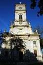 Saint Joseph Calasanctius Church
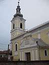 The Calvinist church
 The synagogue
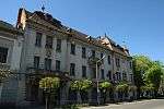 The town hall
 The Romanian Soldiers' Monument
 The Károlyi castle
 The Károlyi castle
 The Károlyi castle
 The castle's water tower
 Coat of Arms on the wall of the Károlyi castle
References
- ↑ Ujfalussy Amadil: Nagykároly
- ↑ (Romanian) Populația stabilă după etnie - județe, municipii, orașe, comune, National Institute of Statistics; accessed August 14, 2016
- ↑ "Partnerstwo Samorządów Siłą Europy". Europa Miast (in Polish). Retrieved 13 August 2013.
- ↑ "Dębica -Miasta Partnerskie" [Dębica – Partnership Cities]. Rząd Miejski w Dębicy – Współpraca – Europa Miast [Dębica town council in cooperation with Europa Miast] (in Polish). Archived from the original on 11 October 2011. Retrieved 13 August 2013.
- ↑ "Geografie" (in Romanian). www.satu-mare.ro. Archived from the original on 12 June 2009. Retrieved 22 June 2009.
- ↑ "Weatherbase data for Satu Mare". Retrieved 22 June 2009.
External links
| Wikimedia Commons has media related to Carei. |
- Official site of Carei (Romanian)
- Nagykárolyi Napló (Hungarian)