Pegasus Field
| Pegasus Field | |||||||||||
|---|---|---|---|---|---|---|---|---|---|---|---|
 White ice runway at Pegasus Field | |||||||||||
| IATA: none – ICAO: NZPG | |||||||||||
| Summary | |||||||||||
| Location | McMurdo Station, Ross Island, Antarctica | ||||||||||
| Elevation AMSL | 18 ft / 5 m | ||||||||||
| Coordinates | 77°57′48″S 166°31′28″E / 77.96333°S 166.52444°ECoordinates: 77°57′48″S 166°31′28″E / 77.96333°S 166.52444°E | ||||||||||
| Map | |||||||||||
 NZPG Location of airfield in Antarctica | |||||||||||
| Runways | |||||||||||
| |||||||||||
Pegasus Field (ICAO: NZPG) is an airstrip in Antarctica, the southernmost of three airfields serving McMurdo Station. Pegasus was originally conceived as a blue ice runway capable of handling wheeled aircraft year-round, but as it was developed, it was enhanced with a 4-inch layer of compacted snow on top—thus more properly characterizing it as a white ice runway. [3] The other two are the snow runways at Williams Field (ICAO: NZWD) that are limited to ski-equipped aircraft, and the Ice Runway (ICAO: NZIR) on the sea-ice available during the summer Antarctic field season.
The field is named after Pegasus, a C-121 Lockheed Constellation, still visible there in the snow after crashing in bad weather on October 8, 1970. No one on board was injured.
On September 11, 2008, a United States Air Force C-17 Globemaster III successfully completed the first landing in Antarctica using night-vision goggles at Pegasus Field.[4] Previously air transport in the permanent darkness of the winter was only used in emergencies, with burning barrels of fuel to outline the runway.
In recent seasons, Pegasus has been plagued with warmer temperatures combined with dust and dirt blown in from nearby Black Island, causing excessive melting making the runway unusable at the end of the austral summer season. Accordingly, Pegasus, and the Ice Runway (which has not been consistently used in recent years), were planned to be replaced with a new "Alpha Runway" which will be near Williams Field and be constructed using compressed snow technology. A search for a replacement site began in 2014; serious construction began during the 2015-16 austral summer. The new runway is about 3 miles northwest of Pegasus, to be out of the wind patterns for the Black Island dust. It is based completely on compacted snow, rather than the "blue ice" base under Pegasus. On 7 April 2016 the National Science Foundation officially announced that the new runway would be named the Phoenix Airfield,[5] after the name of a propeller-driven C-121 Constellation transport plane which was flown between Christchurch and McMurdo by the U.S. Navy VX-6 squadron during the 1960s through 1971.
Phoenix Airfield underwent operational testing and has received its first wheeled landings during the 2016-17 austral summer season.[6]
Gallery
 United States Air Force C-5 Galaxy being off-loaded at Pegasus Field.
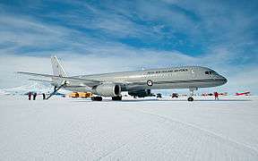 RNZAF Boeing 757 lands at Pegasus Airfield on the Ross Ice Shelf during its maiden flight to Antarctica.
References
- ↑ Airport information for NZPG at World Aero Data. Data current as of October 2006.Source: DAFIF.
- ↑ Airport information for NZPG at Great Circle Mapper. Source: DAFIF (effective October 2006).
- ↑ Wallwork, Ellery D. (October 2006). "Operation Deep Freeze--50 Years of Air Force Airlift in Antarctica 1956-2006 (page 265)" (PDF).
- ↑ Rejcek, Peter (September 26, 2008). "Air Force successfully tests new capability to fly any time of year to McMurdo". Antarctic Sun.
- ↑ "A New Runway for McMurdo Station is Named". National Science Foundation. 7 April 2016.
- ↑ "Phoenix Rising". The Antarctic Sun. 21 November 2016.
External links
| Wikimedia Commons has media related to Pegasus Field. |
- Airfields on Antarctic Glacier Ice Malcolm Mellor and Charles Swithinbank, CRREL 1989.
- Lockheed Aircraft R7V-1 / R7V-1P / C-121J "Constellation" "Connie"
- Installation of runway-Pegasus
- Runway Project Clears the Way for Improved Antarctic Airlift National Science Foundation. February 20, 2002.
- Construction, Maintenance, and Operation of a Glacial Runway, McMurdo Station, Antarctica George L. Blaisdell et al, CRREL Monograph 98-1, March 1998.
- Current weather for NZPG at NOAA/NWS