N'Tentou
| N'Tentou Ténétou | |
|---|---|
| Town | |
|
N'Tentou in 1892 | |
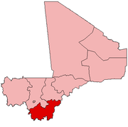
 N'Tentou Location in Mali | |
| Coordinates: 11°21′12″N 7°43′16″W / 11.3533483800765°N 7.72124866310904°WCoordinates: 11°21′12″N 7°43′16″W / 11.3533483800765°N 7.72124866310904°W | |
| Country |
|
| Region | Sikasso Region |
| Cercle | Bougouni Cercle |
| Commune | Kouroulamini |
| Time zone | GMT (UTC+0) |
| [1] | |

N'Tentou or Ténétou is a town and seat of the commune of Kouroulamini in the Cercle of Bougouni in the Sikasso Region of southern Mali.[2]

Map of Tenetou, 1892
References
- ↑ "Ténétou, Mali - Geographical Names, map, geographic coordinates". Geographical Names. Retrieved 2014-05-22.
- ↑ "Previsions de desserte des communes pour la periode de 2001-2005" (PDF). Mali Reforme Telecom. Retrieved February 12, 2009.
This article is issued from Wikipedia - version of the 5/22/2014. The text is available under the Creative Commons Attribution/Share Alike but additional terms may apply for the media files.