Mwdwl-eithin
| Mwdl-eithin | |
|---|---|
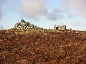 Mwdwl-eithin peak with cairn on left and trig point obscured by ruined building | |
| Highest point | |
| Elevation | 532 m (1,745 ft) |
| Prominence | 265 m (869 ft) |
| Parent peak | Carnedd y Filiast |
| Listing | Marilyn |
| Coordinates | 53°04′22″N 3°37′04″W / 53.0727°N 3.6178°WCoordinates: 53°04′22″N 3°37′04″W / 53.0727°N 3.6178°W |
| Geography | |
| Location | Conwy, Wales |
| Parent range | Snowdonia |
| OS grid | SH917540 |
| Topo map | OS Landranger 115 |
Mwdwl-eithin (532 metres (1,745 ft)) is the highest point on the Denbigh Moors (Welsh: Mynydd Hiraethog) of North Wales. This gently rising mountain lies about 10 miles (16 km) east of Betws-y-Coed. On its summit is a trig point and a ruined building which still provides shelter against a storm. A few metres away is a large raised stone cairn.
The whole area is underlain by Silurian mudstone which was extensively glaciated during the last British glaciation. The whole area is now very wet moorland dominated by heather (Calluna and Erica spp.) and rushes. Three of the surrounding valleys and depressions have been used for drinking water storage reservoirs, Llyn Alwen, Llyn Aled and Alwen Reservoir.
This article is issued from Wikipedia - version of the 12/12/2015. The text is available under the Creative Commons Attribution/Share Alike but additional terms may apply for the media files.