Katni
| Katni कटनी Mudwara Katni | |
|---|---|
| City | |
| Nickname(s): City of Marvel (Limestone) | |
 Katni Location in Madhya Pradesh, India | |
| Coordinates: 23°29′N 80°24′E / 23.48°N 80.40°ECoordinates: 23°29′N 80°24′E / 23.48°N 80.40°E | |
| Country |
|
| State | Madhya Pradesh |
| District | Katni |
| Government | |
| • Type | Elected |
| • Body | Municipal Corporation |
| • Mayor | Shashank Shrivastava(C.A.) (BJP) |
| Elevation | 304 m (997 ft) |
| Population (2011)[1] | |
| • Total | 221,875 |
| • Density | 350/km2 (900/sq mi) |
| Languages | |
| • Official | Hindi |
| Time zone | IST (UTC+5:30) |
| PIN | 483501 |
| Telephone code | 91 7622 |
| Vehicle registration | MP 21 |
| Website |
katni |
Katni (also known as Murwara (Katni) or Mudwara) is a town on the banks of the Katni River in Madhya Pradesh, India. It is the administrative headquarters of Katni District. It is in the Mahakoshal Region of Central India. The city is 90 km (56 mi) from the Divisional Headquarters of the region, Jabalpur. It is one of largest railway junctions in India and has the largest railyard and second biggest diesel locomotive shed in India.[2] The city has an abundance of lime and bauxite. It also has the Ordnance Factory Katni of the Ordnance Factories Board which manufactures products for the Indian Armed Forces. [3]
History
Katni is a conglomeration of culture from three cultural states — Mahakausal, Bundelkhand, and Baghelkhand. There are three stories which may explain why Katni is called Mudwara.
Katni junction has a half circular Mode (turn) from the wagon yard. So people call it “Mudwara”.
Another story is that there was a village called Modwar that was given as a reward for the bravery of cutting Mud (heads).
A similar story is that the British government used to cut the heads of baggies and plunderers, and hang them in squares to instill fear in the population and deter them from criminal activity.
Transport
Railways
Katni | |||||||||||||||||||||||||||||||||||||||||||||||||||||||||||||||||||||||||||||||||||||||||||||||||||||||||||||||||||||||||||||||||||||
|---|---|---|---|---|---|---|---|---|---|---|---|---|---|---|---|---|---|---|---|---|---|---|---|---|---|---|---|---|---|---|---|---|---|---|---|---|---|---|---|---|---|---|---|---|---|---|---|---|---|---|---|---|---|---|---|---|---|---|---|---|---|---|---|---|---|---|---|---|---|---|---|---|---|---|---|---|---|---|---|---|---|---|---|---|---|---|---|---|---|---|---|---|---|---|---|---|---|---|---|---|---|---|---|---|---|---|---|---|---|---|---|---|---|---|---|---|---|---|---|---|---|---|---|---|---|---|---|---|---|---|---|---|---|
Legend
Source: Google maps | |||||||||||||||||||||||||||||||||||||||||||||||||||||||||||||||||||||||||||||||||||||||||||||||||||||||||||||||||||||||||||||||||||||

One of the prime junctions of Indian railways, Katni Junction is in the heart of the rail network. Trains come to Katni from five directions (Bina, Jabalpur, Satna, Bilaspur, Singrauli), as it is at the junction of trunk rail routes connecting north-south and east-west. The public has access to almost all parts of the country directly through mail express trains from Katni. The railways are now establishing a new zone at Jabalpur.
There are more than 5,000 railway employees at Katni. Katni is the second biggest diesel locomotive shed of the Indian Railways,[4] housing 200 locomotives. It has an electric locomotive shed holding 100 locomotives. Katni is home to Indian railway's biggest wagon repair shop. A complete new township has been developed at Katni Junction.
Railway stations
Katni is advantageously situated near the central Indian coal fields and the power plants of North and Western India. The nearest airport is at Jabalpur, around 100 kilometres (62 mi) distant. Daily flights are available to Delhi and Mumbai.
Road
Katni is connected by road to Varanasi, Nagpur, Bhopal, Raipur, Allahabad, Hyderabad, and Bangalore. The longest national highway of India, i.e., National Highway 7 runs through the city. NH 78 starts from Katni connecting Shahdol, Ambikapur and to Gumla.
Culture
Dussehra is the biggest annual festival in Katni district. The effigy of Ravana made here ranges in height from 43 to 49 metres (141–161 ft) in Kymore near Vijayraghavgarh every year. People from far away visit to witness the event. Burning of the effigy was temporarily discontinued due to safety reasons and has resumed.
Hotels
Katni has recently become home to some good hotels. Namely, The Arindum, Hotel Grand Meridian, Hotel Samdareeya, Hotel Raj Palace.


Administration
Katni has had the status of town since the beginning of the 20th century. Town development work started under British rule. On 28 May 1998 Katni was declared as a district.
Tehsils
1. Katni Mudwara 2. Vijayraghavgarh 3. Bahoriband 4. Dheemarkheda 5. Badwara 6. Rithi 7. Barhi
Sub Tehsils
1. Sleemnabad 2. UmariaPan
Lagislature Assembly
1. Rithi Mudwara 2. Vijayraghavgarh 3. Bahoriband 4. Badwara
Demographics
As of the 2011 census, Murwara (Katni) municipality had a population of 221,875.[1] The municipality had a sex ratio of 921 females per 1,000 males and 11.3% of the population were under six years old.[1] Effective literacy was 87.43%; male literacy was 92.77% and female literacy was 81.64%.[1]
Education
There are more than 13 higher secondary schools in Katni. Out of them, more than five are affiliated with the Central Board of Secondary Education and provide education to upper higher secondary level. Colleges offering graduate and postgraduate courses are present in Katni.
The Krishi Vigyan Kendra Katni agricultural university is on the NH 7, inside Piprodh village, where along with the transfer of technology and assessment of technology, the quality seed production program of field crops is undertaken.
One Technical Polytechnic Diploma College and many ITI College are present. Katni has the head office of the Maharishi Mahesh Yogi Vedic University.
Colleges
- Govt. Tilak Rashtriya College
- Govt. Girls College
- Govt. Polytechnic College
- Govt. ITI College Katni
- SYNA International College of Management Studies (Commerce, General & Hotel Management)
- Katni Degree College
- Katni Arts and Commerce College
- Tavite College
- Nalanda B.Ed college katni
Other Colleges.
Govt. Degree College Vijayraghavgarh
Kymore Science College Vijayraghavgarh
Sramdham Arts & Commerce College Kymore, Vijayraghavgarh
Govt. Degree College Barhi
Govt. Degree College Bahoriband
Govt. Degree College Sleemnabad
Govt. Degree College Badwara
Rajiv Gandhi Arts & Commerce College Rithi
Govt. Degree College Dhimarkheda
Swami Dwarka das College Dhimarkheda
Govt. Degree College Umaria Pan
Schools
- JPV DAV Public School, Katni
- Jovial Public School, Sant Nagar, Katni
- Sacred Hearts English Medium Higher Secondary School
- Syna International School
- Kendriya Vidyalaya NKJ (Railway)
- Kendriya Vidyalaya No.1 Ordnance Factory Katni
- St. Paul's Senior Secondary School, Katni
- Delhi Public School
- Bardsley Higher Secondary School
- DAV ACC Public School
- Nalanda Higher Secondary School, Civil Lines
- Maharshi Vidya Mandir
- HD Memorial School
- Toddlers academy
- Kids Care Higher secondary school
- Saraswati higher secondary school
- Jain Higher Secondary School
Historical Places
Bahoriband
In Bahoriband there are many monuments; there is a statue of Jain Teerthankar Shantinath 12 feet high. There is some scripture of 12th century are written in lower part of the statue telling about Maha Samantadhipati Golhneshwar Rathore who was the ruler under Kalchuri’s kings Gayakarndev.
Tigavan Temple
Earlier Tigavan was part of Bahoriband. People say the earlier name of Tigavan village was Jhanjhangad. Aalha and Udal fought with king of Madhogarh in Tigavan. A 1500-year-old temple of 1500-year-old can that has a flat ceiling. There is a statue of lord Narsing and on other side of wall there is Jain Treethankars Parshvanath statue.
There are many statues in north of the village. Near the reservoir a stone has been found in which 10 incarnation of Lord Vishnu has been painted. There are many statues of Narayan Shaishayani (bed) and sun (Lord Surya). There is a cemetery of Oliya Peeran Peer and a village is associated with it. Nowadays, Bahoriband has gained more importance and fame after stone park.
Roopnath Temple
Roopnath is a pilgrimage place 3 km from Bahoriband. There is Panchlingi (five lingam) statue of Lord Shiva and called Roopnath. It is in the corner of Camore mountain, There are three kunds (tanks) one above another on a standing stone. Water is present all the time. The lowest is called Sita Kund, next above it is Laxman Kund, and the topmost is known for Lord Ram.
There is verse painted on big stone that may be of 232 B.C. Some order like is written in Pali language for following Buddhism. It describes that 2½ years of Ashoka following Buddhism but nothing has been achieved so far. One km from Roopnath in Sindursi village four old statues have been removed from mountain this place is known as Jogini Ka Sthan (place of Jogini). It is believed that the statues are linked with King Jainat or Sarvanth of the 6th century.
Vijayraghavgarh
33 km from Katni, Vijaraghavgarh is a historical place, which is 350 m high from sea level. Prince PRAYAGDAS had formed a new town near MAUJA, PADRIYA and LOHARWADA and constructed a temple of lord VIJAYRAGHAV and the fort was named VIJAYRAGHAVGARH.
The new town has been given the same name. At one side of this fort a court is available, Other side is of a beautiful building known as RANGMAHAL. There are stone at parts of the fort designed from KARITALAI.
Vijayraghavgarh Sharda Devi Temple
Maa sharda temple is located ITI Road (Karitalai Road) Vijayraghavgarh.
Bilhary
In the ancient time this locality was known very much scattered it was around in 24 miles of diameter. The old name of this town was PAHUPAVTI/PUSHPAWATI NAGRI (Town). Today many scriptures are found in this area. There were many temples the only remain is VARAH temple of lord VARAH (Vishnu). There is one more temple around one km from Bilhari of lord Shiva it also known as fort of Kamakandla in the ancient building archeologist have found a big scripture on rock on a stone which is currently in Nagpur museum in which description of Culchuries king Kayoorvarsh is found and about construction of temple for lord NOHLESHWAR (lord Shiva) second part of scripture describes visiting of Somnath temple in Gujrat for victory of Laxmanraj son of princes Nohla.
King laxman has made the big reservoir in Bilhari. The dynasty has decline very fast and Chandel kings has captured the area after ward. Pan(Tambul) of Bilhary is very much famous the reference is found in famous scripture Aeana Akhbari.bilahri is a puspawati nagari
Sungarha Vaishnav Devi Mandir
Vaishnav Devi Mandir, Sungarha Vaishnav Devi temple is 15 km from Katni on Katni-Panna road. This place is quite famous, and people come to visit it. This is a favourite picnic destination for Katni people.
Badera Chaturyug Dham
Chaturyug Dham, Badera Chaturyug Dham is located 8n Badera Village of distt katni. Charturyug Dham is 15 km from katni in maihar road (N.H.7). Around 15 yrs old this temple is located 2 km off the road. This is nicely explains the governing of the four yugs of Hindu mythology. The first flore is dedicated to 'Satyug', the second is 'Treta yug', the third one is 'Dwapar yug' and the top is 'Kaliyug'. The temple is high enoughvand offers to get nice panoramic view of the village and nearby area
Gallery
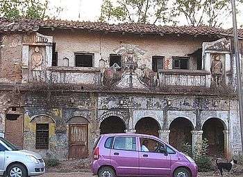 An old building in Katni commemorating India's freedom, with statues of Nehru, Gandhi and Subhas Chandra Bose
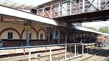 Katni Station inner portion
 Dakshin Mukhi Hanuman Mandir Katni
 Jain images consecrated in 1491 AD at a Jain temple in Bilhari, Katni
See also
- Vijayraghavgarh Sharda Devi Temple
- Vijayraghavgarh Fort
- Pachmatha Dham Ganesha Temple
References
- 1 2 3 4 "Provisional Population Totals, Census of India 2011; Cities having population 1 lakh and above" (pdf). Office of the Registrar General & Census Commissioner, India. Retrieved 27 March 2012.
- ↑ "Official Website". http://katni.nic.in/. External link in
|publisher=(help); - ↑ http://ofbindia.gov.in/units/index.php?unit=ofkat
- ↑ http://irsme.nic.in/files/DieselShedVishakh-02072010.pdf