Mount Juliet, Tennessee
| Mt. Juliet, Tennessee Mount Juliet | ||
|---|---|---|
| City | ||
| ||
| Motto: The City Between The Lakes | ||
 Location in Wilson County and the state of Tennessee | ||
| Coordinates: 36°12′10″N 86°30′49″W / 36.20278°N 86.51361°WCoordinates: 36°12′10″N 86°30′49″W / 36.20278°N 86.51361°W | ||
| Country | United States | |
| State | Tennessee | |
| County | Wilson | |
| Founded | 1835[1] | |
| Incorporated | 1972[1][2] | |
| Named for | Mount Juliet Estate (County Kilkenny, Ireland)[3] | |
| Government | ||
| • Mayor | Ed Hagerty | |
| Area | ||
| • Total | 25.1 sq mi (64.9 km2) | |
| • Land | 24.7 sq mi (64.0 km2) | |
| • Water | 0.3 sq mi (0.9 km2) | |
| Elevation | 683 ft (208 m) | |
| Population (2015)Special Census | ||
| • Total | 28,159 | |
| • Density | 761/sq mi (293.8/km2) | |
| Time zone | CST (UTC-6) | |
| • Summer (DST) | CDT (UTC-5) | |
| ZIP code |
37121 (P.O. boxes) 37122 (gen. delivery) 37138 (northwestern gen. delivery) | |
| Area code(s) | 615, 629 | |
| Website | www.cityofmtjuliet.org | |
Mount Juliet[2] (more commonly known as Mt. Juliet[4]) is a city located in western Wilson County, Tennessee. A suburb of Nashville, it is approximately 17 miles (27 km) east of downtown Nashville. Mt. Juliet is located mostly between two major national east-west routes, Interstate 40 and U.S. Route 70. As of the 2015 special census, the city has a total population of 28,156. Mt. Juliet is the largest city in Wilson County
History
Mt. Juliet was formed in 1835 and incorporated as a city in 1972.[1][2] According to the Mt. Juliet Chamber of Commerce, the name of the town has two possible explanations. One theory is that the town was named for Julia Gleaves, a person who was renowned for taking care of those in need within the community. The most widely accepted story is that Mt. Juliet is named for the Mount Juliet Estate, a manor house in County Kilkenny, Ireland. It is the only U.S. city with this name.[5]
Geography
_welcoming_commuters_to_Mt._Juliet..jpg)
Mt. Juliet is located at 36°12'10" North, 86°30'49" West (36.202654, −86.513583).[6]
According to the United States Census Bureau, the city has a total area of 16.6 square miles (43 km2), of which 16.2 square miles (42 km2) is land and 0.3 square miles (0.78 km2) is water. The total area is 1.99% water. Recent annexations along the east side of South Rutland Road as well as a land swap with the City of Lebanon for the Bel Air at Beckwith project (southeast quadrant of I-40/Beckwith Road interchange) have increased the city's geographical area to approximately 21.78 square miles (56.4 km2).
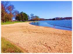
Mt. Juliet's official city slogan is "The City Between The Lakes", reflecting the city's proximity to Old Hickory Lake (Cumberland River) to its north and Percy Priest Lake (Stones River) to its south, both of which are man-made reservoirs.
Demographics
| Historical population | |||
|---|---|---|---|
| Census | Pop. | %± | |
| 1980 | 2,879 | — | |
| 1990 | 5,389 | 87.2% | |
| 2000 | 12,366 | 129.5% | |
| 2010 | 23,671 | 91.4% | |
| Est. 2015 | 31,540 | [7] | 33.2% |
| Sources:[8][9] | |||
As of the census[10] of 2000, there were 12,366 people, 4,341 households, and 3,576 families residing in the city. The population density was 761.2 people per square mile (293.8/km²). There were 4,673 housing units at an average density of 287.6 per square mile (111.0/km²). The racial makeup of the city was 93.86% Caucasian, 3.93% African American, 0.39% Native American, 0.52% Asian, 0.01% Pacific Islander, 0.29% from other races, and 1.00% from two or more races. 1.17% of the population were Hispanic or Latino of any race.

There were 4,341 households out of which 46.0% had children under the age of 18 living with them, 67.3% were married couples living together, 11.2% had a female householder with no husband present, and 17.6% were non-families. Thirteen-point-eight percent of all households were made up of individuals and 3.3% had someone living alone who was 65 years of age or older. The average household size was 2.82 and the average family size was 3.12.
In the city the population was spread out with 30.5% under the age of 18, 6.5% from 18 to 24, 35.3% from 25 to 44, 21.4% from 45 to 64, and 6.3% who were 65 years of age or older. The median age was 34 years. For every 100 females there were 95.4 males. For every 100 females age 18 and over, there were 93.4 males.
In 2014, the median income for a household in the city was $73,512 and the median family income is $78,443. The medium value of owner-occupied housing units is $200,000. 2.4% of the population and 1.7% of families were below the poverty line. 3.2% of those under the age of 18 and 4.0% of those 65 and older were living below the poverty line. Wilson County is the 2nd wealthiest county in Tennessee.
Mt. Juliet has claimed to be the "fastest-growing city in Tennessee," and it does qualify for this distinction if one considers growth from 2000–2015 for Tennessee cities with a population over 10,000. In recent years, Thompsons Station in Williamson County and Spring Hill in Williamson County have grown by a larger percentage basis. Mt. Juliet remains one of the fastest growing places in Tennessee.
Government and politics
Mt. Juliet was incorporated in 1972 and operates on a "city manager-commission" system.[2] The city has five elected leaders: four commissioners (Ray Justice, James Maness, Art Giles and Brian Abston – one from each of the city's four districts), and a mayor (Ed Hagerty) elected at large and serving as chairperson of the city commission. Elected officials, including the mayor, are not employed full-time by the city. The commission selects and appoints a city manager, who is employed full-time and runs the city's business on a day-to-day basis. All elected city officials serve four-year terms.
Mt. Juliet currently serves as the anchor city for Tennessee House of Representatives District 57 and Tennessee Senate District 17. In 2012, after many years in Tennessee's 5th congressional district, Mt. Juliet was redistricted into Tennessee's 6th congressional district.
Education

Mt. Juliet schools are operated by the Wilson County School District.
The Mt. Juliet area is regarded to have one of the Top 10 best school systems in the State of Tennessee.[11]
Mt. Juliet High School (Golden Bears), is located just outside the city limits, although many students residing within the city are also zoned to Wilson Central High School (Wildcats), located in nearby Lebanon. Mt. Juliet High School moved into a brand new building which opened August 11, 2008 for the 2008–2009 school year. The old Mt. Juliet High School became Mt. Juliet Middle School and the old Mt. Juliet Middle School became Elzie D. Patton Elementary.
Two middle schools are located within the city limits:
- Mt. Juliet Middle (feeds to MJHS) (Golden Bears)
- West Wilson Middle (feeds to either WCHS or MJHS) (Wildcats, previously known as the Wolves)
Mt. Juliet students are zoned to several elementary schools:
Feeding to Mt. Juliet Middle School, and ultimately to Mt. Juliet High School:
- Mt. Juliet Elementary (Bears)
- W.A. Wright Elementary (Knights)
- Lakeview Elementary (Golden Eagles)
- Elzie D. Patton Elementary (Patriots)
Feeding to West Wilson Middle School, and ultimately to Wilson Central High School:
- Stoner Creek Elementary (Bobcats)
- West Elementary (Bulldogs)
- Rutland Elementary (Rockets)
- Gladeville Elementary (Gators)
Future Wilson County Schools in Mt. Juliet, Tennessee:
- Springdale Elementary (Opening Fall 2017)
- Golden Bear Gateway (New Elementary/Middle School)
- Lebanon Rd./N Greenhill Rd. (New High School)
More information can be found on the capital outlay plan on the Wilson County School District website.
The city is home to one K-12 private school, Mount Juliet Christian Academy (Saints), located within First Baptist Church, although dozens of other private schools are located within a 30-minute drive, including Friendship Christian School (Commanders) in Lebanon, as well as Donelson Christian Academy (Wildcats) in Donelson. Other prep schools not affiliated with religious organizations can be found in Nashville. There are four "tutorial programs" which meet weekly in Mt. Juliet for home-schooled high school students. Wilson County's only Montessori School, Mt Juliet Montessori Academy, opened in Fall 2007.

Cumberland University has a satellite campus in Mt. Juliet. The nearest community college, Volunteer State Community College, is 20 miles (32 km) north in Gallatin. The nearest public college/university is Tennessee State University, located 20 miles (32 km) west in Nashville. The nearest private college/university is Cumberland University, 14 miles (23 km) east in Lebanon. Several other public and private colleges and universities are nearby in Nashville and Murfreesboro.
Transportation
Interstate 40 and U.S. Route 70 (Lebanon Road) run east/west through Mt. Juliet, and State Route 171 (Mt Juliet Road) runs north-to-south connecting US-70 to I-40, before continuing toward Interstate 24 in the Antioch area.
Mt. Juliet serves as a stop on the Music City Star commuter rail service from Nashville to Lebanon, operating over freight carrier Nashville and Eastern Railroad. The Music City star has stations in downtown Nashville, Donelson, Hermitage, Mt. Juliet, Martha (HY. 109), and Lebanon. The Music City Star also runs trains for Tennessee Titans games, New Year's Eve, Wilson County Fair, other events downtown Nashville. Additionally, a Friday night train has been added to give Mt. Juliet residents the option of taking the train for Friday night excursions.
For commercial air traffic, Mt. Juliet is served by Nashville International Airport, located 9 miles (14 km) west of the city via Interstate 40.
Entertainment and shopping

A new, large-scale commercial and residential development called "Providence Marketplace" is located on the city's southern side near Interstate 40. Tenants include Target, Belk, JCPenney, Best Buy, PetSmart, Old Navy, Kroger, and a 14-screen multiplex operated by Regal Entertainment.
Providence Commons is a 200,000 square foot shopping center on a 30.8-acre site on South Mt. Juliet Road and Providence Parkway. It is anchored by a 54,000 square foot Publix Supermarket, with three to four anchor and junior anchor tenants, small shop retail, and six outparcels.[12]
Mt. Juliet Crossing is a 37+ acre development of office and retail located in Mt. Juliet at Central Pike and South Mt. Juliet Road, with tenants including Hampton Inn & Suites, restaurants, Walgreens, retail stores, and medical offices.
Adams Lane Plaza is a 35,000 square foot retail center located in Mt. Juliet at Interstate 40 and South Mt. Juliet Road.
Paddock Place offers one million square feet of retail and office space located in on North Mt. Juliet Road just off Interstate 40. Its anchor tenants include Lowe's, Academy Sports & Outdoors and Wal-Mart, plus restaurants and retail outlets.
Currently many homes, apartments, retail and mixed use projects are either proposed or under construction in the Mount Juliet area.
In 1999, citizens voted to allow Liquor-By-The-Drink sales inside the city limits, in the hope of attracting major chain restaurants.
Companies that have facilities in Mount Juliet include FedEx and Under Armour.[13]

Nashville Superspeedway, a 1.33-mile (2.14 km) oval hosting NASCAR Busch Series, Craftsman Truck Series, and Indy Racing League events, is located in nearby Gladeville. In 2011 the track notified NASCAR that it would not seek sanctioned races for 2012,[14] but remains available for Race Team Testing.[15]
Recreation
Mt. Juliet has five public parks:
- Charlie Daniels Park (named in honor of the musician who makes his home in Mt. Juliet) is home to tennis courts, a large children's playground, the city's youth football fields, and the Mt. Juliet Community Center (a public meeting place and gymnasium). The parks also has a "splash pad" for children in the summer months.[16]
- Sgt. Jerry Mundy Memorial Park (named in honor of a city police officer killed in the line of duty on July 9, 2003) features four softball fields, a soccer field, a frisbee golf course, and a smaller playground. Prior to 2003, this park was called "Millennium Sportsplex."
- South Mt. Juliet City Park has a pavilion, sand volleyball court, children's play area, and nature trail in addition to Mt. Juliet's very own "Bark Park," a ¾ acre fenced-in area allowing people and their dog playspace.
- Robinson Park is an 11-acre park on Mt. Juliet Rd. (next to Robinson Crossing). It hosts a ½ mile wraparound hiking trail and outdoor fitness equipment. The park offers homes to birds, bees, bats, lady bugs, and butterflies. Robinson Park is a Certified Wildlife Habitat.[17]
- Jones Family Park hosts a sand volleyball court, Frisbee Golf Range, a walking trail, and picnic areas. It also offers a ½ acre fenced in "Bark Park" for dogs to enjoy and a miniature Frisbee Golf Course.[18]
- Cedar Creek Access Area (Old Hickory Lake)
Three state parks are located within a 30-minute drive of the city:
- Long Hunter State Park, 7 miles (11 km) to the south.
- Bicentennial Mall State Park, app. 18 miles (29 km) to the west in downtown Nashville.
- Cedars of Lebanon State Park, app. 20 miles (32 km) to the southeast.
The privately owned little league park features more than a dozen baseball and softball fields.
Fishing and boating are popular pastimes in Mt. Juliet, resultant of the city's proximity to Percy Priest and Old Hickory Lakes.

Swimming is an up-and-coming sport in Mt. Juliet and West Wilson County. Two summer league teams exist: one at Langford Farms and the other at Willoughby Station.
City services
The City of Mt. Juliet operates a police department. Ambulance service are provided by WEMA (the Wilson Emergency Management Agency). The city has a combination career and volunteer Fire Department (MJFD) with one station on Belinda Parkway and another station located on Hill Street.[19] MJPD is currently is discussions to open a third fire station on the north side of Mt. Juliet. There is one WEMA fire station also within the city limits. Mt. Juliet has a new police station near Charlie Daniels Park on the city's northwest side. In December 2008, the Mt. Juliet Police Department Animal Control Division opened a shelter on Industrial Drive.
Media/communications
Mt. Juliet High School hosts a student-run news program called BNN (Bear News Network) on Channel 9 each school day for a short period with club meetings and announcements and the station runs the rest of the time with school and community information in the form of a slide presentation. The audio on Channel 9 is provided by WPLN-FM, Nashville's NPR affiliate.
Mt. Juliet is currently served by three weekly newspapers, The Mt. Juliet News (50¢), The Wilson Post (50¢) and The Chronicle of Mt. Juliet (free), both published on Wednesdays. Mt. Juliet also falls within the circulation areas of daily newspapers The (Nashville) Tennessean and the Lebanon Democrat.
Notable residents
- Levi Brown, professional football player
- Bobby Hamilton, NASCAR driver
- Don Ray, professional basketball player
- Dale Wainwright, Texas Supreme Court
- Ross Winn, politician
- Barry Wilmore, astronaut
- Amanda Butler, basketball coach
- Michael Jasper, professional football player
- Alysha Clark, professional basketball player
- James Wilhoit, professional football player
Musicians
- Owen Bradley
- Charlie Daniels
- Tracey Lawrence
- Collin Raye
- Leon Russell
- Sid Harkreader
- Erika Jo
- Johnnie Wright
- David P. Sartor
- Bill Anderson
- Darryl Worley
- Adrian Belew
- Tiffany
- Kings of Leon members, the Followill family
- Ben Hayslip songwriter of the year (2011, 2102)
References
- 1 2 3 About Mt. Juliet, Mt. Juliet Chamber Commerce website. Retrieved: April 24, 2013.
- 1 2 3 4 "CITY MANAGER-COMMISSION CHARTER" (PDF). Mount Juliet, Tennessee. p. C-1. Retrieved November 16, 2014.
- ↑ Larry Miller, Tennessee Place Names (Indiana University Press, 2001), p. 144.
- ↑ "Mt. Juliet (official website)". Mount Juliet, Tennessee. Retrieved November 17, 2014.
- ↑ Mt. Juliet West Wilson Chamber of Commerce – Community Information
- ↑ "US Gazetteer files: 2010, 2000, and 1990". United States Census Bureau. February 12, 2011. Retrieved 2011-04-23.
- ↑ "Annual Estimates of the Resident Population for Incorporated Places: April 1, 2010 to July 1, 2015". Retrieved July 2, 2016.
- ↑ "Census of Population and Housing: Decennial Censuses". United States Census Bureau. Retrieved 2012-03-04.
- ↑ "Incorporated Places and Minor Civil Divisions Datasets: Subcounty Resident Population Estimates: April 1, 2010 to July 1, 2012". Population Estimates. U.S. Census Bureau. Retrieved December 11, 2013.
- ↑ "American FactFinder". United States Census Bureau. Retrieved 2008-01-31.
- ↑ "Top 10 TN public schools and school districts in Tennessee - NeighborhoodScout". www.neighborhoodscout.com. Retrieved 2016-02-04.
- ↑ "Providence Commons". Retrieved 2012-09-27.
- ↑ "Under Armour announces new $100M distribution center in Tennessee, 1,500 new jobs". October 2, 2014.
- ↑ Dover Motorsports, Inc Declines 2012 Nascar Sanctions for Nashville Motorspeedway, August 3, 2011, archived from the original on August 12, 2013, retrieved 2013-08-23
- ↑ "Nashville Superspeedway continues to be available for race team testing in 2013". April 5, 2013. Archived from the original on August 12, 2013. Retrieved August 23, 2013.
- ↑ "Ava's Splash Pad". www.cityofmtjuliet.org. Retrieved 2016-02-04.
- ↑ "Robinson Park". www.cityofmtjuliet.org. Retrieved 2016-02-04.
- ↑ "Jones Family Park". www.cityofmtjuliet.org. Retrieved 2016-02-04.
- ↑ http://www.jrn.com/newschannel5/news/264335671.html
External links
- official website
- Mt. Juliet-West Wilson Chamber of Commerce
- Wilson Co., TNGenWeb: Mount Juliet, Ireland – Mount Juliet, Tennessee: Truth, Tradition & Theory
- Genealogy.com: GenForum: Gleaves Family Genealogy Forum: MT. JULIET & JULIA GLEAVES
Municipalities and communities of Wilson County, Tennessee, United States | ||
|---|---|---|
| Cities | ||
| Town | ||
| CDPs | ||
| Unincorporated communities | ||
| Ghost towns | ||