Mount Storm King
This article is about the mountain in Clallam County, Washington. For mountains with similar names, see Storm King Mountain.
| Mount Storm King | |
|---|---|
 | |
| Highest point | |
| Elevation | 4,500+ft (1,370+m) NGVD 29[1] |
| Prominence | 750 ft (230 m) [1] |
| Coordinates | 48°03′21″N 123°44′27″W / 48.055708811°N 123.740815125°WCoordinates: 48°03′21″N 123°44′27″W / 48.055708811°N 123.740815125°W [2] |
| Geography | |
 Mount Storm King | |
| Parent range | Olympic Mountains |
| Topo map | USGS Lake Sutherland |
| Climbing | |
| Easiest route | Mount Storm King trail, class 3 |
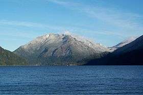
Mount Storm King is located within the Olympic National Park about 20 miles west of Port Angeles, Washington. The mountain is located on the south side of Lake Crescent near Barnes Point, and has an elevation of 4,500+feet (1,370+m).
The trail to the summit starts near the Storm King Ranger Station, and initially follows the trail to Marymere Falls but branches to the north after a short distance. The first 1.9 miles (3.1 km) miles is on maintained trail but the rest of the climb involves scrambling on loose rock with some exposure.[3]
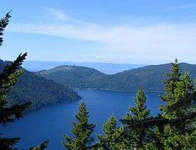
Taken June, 2006 on the summit trail. Lake Crescent is visible in the foreground, the Strait of Juan de Fuca in the background just over seven miles distant.
References
- 1 2 "Mount Storm King, Washington". Peakbagger.com.
- ↑ "CON". NGS data sheet. U.S. National Geodetic Survey.
- ↑ Molvar, Erik (2008). Hiking Olympic National Park (2nd ed.). Helena, Mont: Falcon. ISBN 0-7627-4119-8.
External links
This article is issued from Wikipedia - version of the 9/18/2016. The text is available under the Creative Commons Attribution/Share Alike but additional terms may apply for the media files.