Mount Kaguyak
| Mount Kaguyak | |
|---|---|
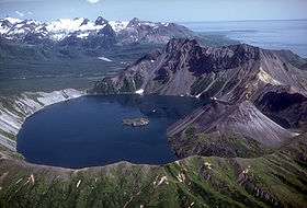 Lake filled caldera of Kaguyak, August 1982. | |
| Highest point | |
| Elevation | 2,956 ft (901 m) |
| Coordinates | 58°36′28.8″N 154°1′40.8″W / 58.608000°N 154.028000°W |
| Geography | |
| Location | Katmai National Park and Preserve, Alaska Peninsula, U.S. |
| Parent range | Aleutian Range |
| Geology | |
| Mountain type | Stratovolcano |
| Volcanic arc/belt | Aleutian Arc |
| Last eruption | 3850 BCE |
Mount Kaguyak is a stratovolcano located in the northeastern part of the Katmai National Park in Alaska. The 2.5 km wide caldera is filled by a more than 180 m deep crater lake. The surface of the crater lake lies about 550 m below the rim of the caldera. Postcaldera lava domes form a prominent peninsula in the center of the lake. The volcano is 901 m high and hosts a spectacular view because it rises from lowland areas near sea level in the south of the Big River. Based on radiocarbon dating the caldera-forming eruption occurred about 5800 years before present.[1] During this eruption at least 120 square kilometers were covered in a dacitic ignimbrite.[2]

Map showing volcanoes of Alaska. The mark is set at the location of Mount Kaguyak
See also
References
Sources
- http://www.springerlink.com/content/p7320l57357p1113/
- "Kaguyak". Global Volcanism Program. Smithsonian Institution.
- Volcanoes of the Alaska Peninsula and Aleutian Islands-Selected Photographs
- Alaska Volcano Observatory
This article is issued from Wikipedia - version of the 1/2/2016. The text is available under the Creative Commons Attribution/Share Alike but additional terms may apply for the media files.