Morgan, Utah
| Morgan, Utah | |
|---|---|
| City | |
|
Morgan's Old Commercial Street | |
 Location in Morgan County and the state of Utah | |
| Coordinates: 41°2′28″N 111°40′34″W / 41.04111°N 111.67611°WCoordinates: 41°2′28″N 111°40′34″W / 41.04111°N 111.67611°W | |
| Country | United States |
| State | Utah |
| County | Morgan |
| Settled | 1860 |
| Named for | Jedediah Morgan Grant |
| Government | |
| • Mayor | Ray Little |
| Area | |
| • Total | 3.2 sq mi (8.3 km2) |
| • Land | 3.2 sq mi (8.3 km2) |
| • Water | 0.0 sq mi (0.0 km2) |
| Elevation | 5,069 ft (1,545 m) |
| Population (2012) | |
| • Total | 3,728 |
| • Density | 823.8/sq mi (318.1/km2) |
| Time zone | Mountain (MST) (UTC-7) |
| • Summer (DST) | MDT (UTC-6) |
| ZIP code | 84050 |
| Area code(s) | 385, 801 |
| FIPS code | 49-51910[1] |
| GNIS feature ID | 1430488[2] |

Morgan is a city in Morgan County, Utah, in the United States. It is part of the Ogden–Clearfield, Utah Metropolitan Statistical Area. It is named after Jedediah Morgan Grant, a leader in The Church of Jesus Christ of Latter-day Saints. As of the 2010 census, the city population was 3,687. It is the county seat of Morgan County.[3] Morgan County is also the location where the film Troll 2 was filmed.
Geography and climate
According to the United States Census Bureau, the city has a total area of 3.2 square miles (8.3 km²), all of it land.
| Climate data for Morgan, Utah (1981–2010) | |||||||||||||
|---|---|---|---|---|---|---|---|---|---|---|---|---|---|
| Month | Jan | Feb | Mar | Apr | May | Jun | Jul | Aug | Sep | Oct | Nov | Dec | Year |
| Average high °F (°C) | 35.8 (2.1) |
40.8 (4.9) |
51.8 (11) |
60.8 (16) |
70.6 (21.4) |
81.2 (27.3) |
90.6 (32.6) |
89.0 (31.7) |
78.4 (25.8) |
65.1 (18.4) |
48.1 (8.9) |
35.9 (2.2) |
62.3 (16.8) |
| Average low °F (°C) | 13.3 (−10.4) |
16.6 (−8.6) |
25.4 (−3.7) |
31.7 (−0.2) |
38.4 (3.6) |
45.1 (7.3) |
52.1 (11.2) |
50.5 (10.3) |
40.7 (4.8) |
31.3 (−0.4) |
23.0 (−5) |
13.8 (−10.1) |
31.8 (−0.1) |
| Average precipitation inches (mm) | 1.53 (38.9) |
1.57 (39.9) |
1.69 (42.9) |
1.66 (42.2) |
1.86 (47.2) |
1.27 (32.3) |
0.65 (16.5) |
0.76 (19.3) |
1.45 (36.8) |
1.61 (40.9) |
1.79 (45.5) |
1.78 (45.2) |
17.61 (447.3) |
| Average snowfall inches (cm) | 15.4 (39.1) |
12.5 (31.8) |
6.3 (16) |
2.4 (6.1) |
0.4 (1) |
0.0 (0) |
0.0 (0) |
0.0 (0) |
0.2 (0.5) |
1.1 (2.8) |
8.6 (21.8) |
13.6 (34.5) |
60.3 (153.2) |
| Source: NOAA[4] | |||||||||||||
Demographics
| Historical population | |||
|---|---|---|---|
| Census | Pop. | %± | |
| 1870 | 1,972 | — | |
| 1880 | 582 | −70.5% | |
| 1890 | 333 | −42.8% | |
| 1900 | 600 | 80.2% | |
| 1910 | 756 | 26.0% | |
| 1920 | 995 | 31.6% | |
| 1930 | 953 | −4.2% | |
| 1940 | 1,078 | 13.1% | |
| 1950 | 1,064 | −1.3% | |
| 1960 | 1,299 | 22.1% | |
| 1970 | 1,586 | 22.1% | |
| 1980 | 1,896 | 19.5% | |
| 1990 | 2,023 | 6.7% | |
| 2000 | 2,635 | 30.3% | |
| 2010 | 3,687 | 39.9% | |
| Est. 2015 | 4,049 | [5] | 9.8% |
As of the census[1] of 2000, there were 2,635 people, 789 households, and 665 families residing in the city. The population density was 823.8 people per square mile (317.9/km²). There were 822 housing units at an average density of 257.0 per square mile (99.2/km²). The racial makeup of the city was 99.09% White, 0.04% African American, 0.04% Native American, 0.08% Asian, 0.30% from other races, and 0.46% from two or more races. Hispanic or Latino of any race were 0.95% of the population. There were 789 households out of which 49.9% had children under the age of 18 living with them, 75.2% were married couples living together, 7.1% had a female householder with no husband present, and 15.6% were non-families. 15.0% of all households were made up of individuals and 8.9% had someone living alone who was 65 years of age or older. The average household size was 3.34 and the average family size was 3.74.
In the city the population was spread out with 37.2% under the age of 18, 10.1% from 18 to 24, 25.1% from 25 to 44, 16.8% from 45 to 64, and 10.7% who were 65 years of age or older. The median age was 27 years. For every 100 females there were 99.2 males. For every 100 females age 18 and over, there were 93.0 males.
The median income for a household in the city was $47,716, and the median income for a family was $53,125. Males had a median income of $42,143 versus $23,011 for females. The per capita income for the city was $16,260. About 2.0% of families and 3.4% of the population were below the poverty line, including 2.6% of those under age 18 and 3.4% of those age 65 or over.
See also
Browning Arms Company, headquartered in the nearby unincorporated community of Mountain Green.
References
- 1 2 "American FactFinder". United States Census Bureau. Retrieved 2008-01-31.
- ↑ "US Board on Geographic Names". United States Geological Survey. 2007-10-25. Retrieved 2008-01-31.
- ↑ "Find a County". National Association of Counties. Retrieved 2011-06-07.
- ↑ "NOWData - NOAA Online Weather Data". National Oceanic and Atmospheric Administration. Retrieved May 5, 2013.
- ↑ "Annual Estimates of the Resident Population for Incorporated Places: April 1, 2010 to July 1, 2015". Retrieved July 2, 2016.
- ↑ "Census of Population and Housing". Census.gov. Retrieved June 4, 2015.
External links
 |
North Ogden Ogden Uintah South Weber |
Huntsville | |
|
| Layton Kaysville, Fruit Heights Farmington |
|
Henefer | ||
| ||||
| | ||||
| Centerville Bountiful Salt Lake City |
Emigration Canyon, Park City | Coalville Hideout, Oakley |
Municipalities and communities of Morgan County, Utah, United States | ||
|---|---|---|
| City | 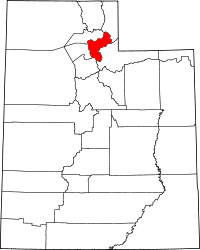 | |
| CDPs | ||
| Unincorporated communities | ||