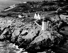
Moose Peak Light
 | |
 | |
| Location | Mistake Island |
|---|---|
| Coordinates | 44°28′28.49″N 67°31′55.17″W / 44.4745806°N 67.5319917°WCoordinates: 44°28′28.49″N 67°31′55.17″W / 44.4745806°N 67.5319917°W |
| Year first constructed | 1827 |
| Year first lit | 1851 (current structure) |
| Automated | 1972 |
| Foundation | Masonry and stone |
| Construction | Brick |
| Tower shape | Conical |
| Markings / pattern | White with black trim |
| Focal height | 72 feet (22 m) |
| Original lens | 2nd order Fresnel lens |
| Current lens | DCB-24 |
| Range | 20 nautical miles (37 km; 23 mi) |
| Characteristic | Fl W 30s |
| Fog signal | HORN: 2 every 30s |
| Admiralty number | J0028 |
| ARLHS number | USA-513 |
| USCG number | 1-1390[1][2][3] |
Moose Peak Light is a lighthouse on Mistake Island, just east of Great Wass Island, Maine at the southern entrance to Eastern Bay and five nautical miles southeast of Jonesport. It was first established in 1827. The present structure was built in 1851. Automated since 1972, the light was sold at auction in January 2013 to a private owner from Connecticut.[4]
References
- ↑ "Historic Light Station Information and Photography: Maine". United States Coast Guard Historian's Office. 2009-08-06.
- ↑ Light List, Volume I, Atlantic Coast, St. Croix River, Maine to Shrewsbury River, New Jersey (PDF). Light List. United States Coast Guard. 2009. p. 16.
- ↑ Rowlett, Russ (2009-10-09). "Lighthouses of the United States: Eastern Maine". The Lighthouse Directory. University of North Carolina at Chapel Hill.
- ↑ D'Entremont, Jeremy. "Moose Peak Lighthouse". New England Lighthouses: A Virtual Guide. Retrieved 23 July 2013.

This article is issued from Wikipedia - version of the 11/21/2015. The text is available under the Creative Commons Attribution/Share Alike but additional terms may apply for the media files.