Monowi, Nebraska
| Monowi, Nebraska | |
|---|---|
| Village | |
|
Population sign seen as one enters Monowi from the east | |
| Nickname(s): "The Biggest Loner" | |
 Location of Monowi, Nebraska | |
 Detailed map of Monowi, Nebraska | |
| Coordinates: 42°49′44″N 98°19′45″W / 42.82889°N 98.32917°WCoordinates: 42°49′44″N 98°19′45″W / 42.82889°N 98.32917°W | |
| Country |
|
| State |
|
| County | Boyd |
| Government | |
| • Mayor | Elsie Eiler |
| Area | |
| • Total | 0.21 sq mi (0.54 km2) |
| • Land | 0.21 sq mi (0.54 km2) |
| • Water | 0 sq mi (0 km2) |
| Elevation | 1,329 ft (405 m) |
| Population (2010)[1] | |
| • Total | 1 |
| • Estimate (2012[2]) | 1 |
| • Density | 4.8/sq mi (1.9/km2) |
| Time zone | Central (CST) (UTC-6) |
| • Summer (DST) | CDT (UTC-5) |
| FIPS code | 31-32550[3] |
| GNIS feature ID | 0831379[4] |

Monowi (/ˈmɒnoʊwaɪ/ MON-o-wy) is an incorporated village in Boyd County, Nebraska, United States. According to the 2010 census, it has a population of just one person,[5] the only incorporated municipality in the United States with such a population.[6]
The name Monowi is said to mean "flower" in a Native American language, but the language has not been identified.[7][8] Monowi was so named from the fact there were many wildflowers growing at the original town site.[9]
History

| Historical population | |||
|---|---|---|---|
| Census | Pop. | %± | |
| 1910 | 109 | — | |
| 1920 | 100 | −8.3% | |
| 1930 | 123 | 23.0% | |
| 1940 | 99 | −19.5% | |
| 1950 | 67 | −32.3% | |
| 1960 | 40 | −40.3% | |
| 1970 | 16 | −60.0% | |
| 1980 | 18 | 12.5% | |
| 1990 | 6 | −66.7% | |
| 2000 | 2 | −66.7% | |
| 2010 | 1 | −50.0% | |
| Est. 2015 | 1 | [10] | 0.0% |
| U.S. Decennial Census[11] 2012 Estimate[12] | |||
Monowi was platted in 1902 when the Fremont, Elkhorn and Missouri Valley Railroad was extended to that point.[13] A post office was established in Monowi in 1902, and remained in operation until it was discontinued in 1967.[14]
Monowi's peak years were in the 1930s, when it had a population of 150.[15] Like many other small communities in the Great Plains, it lost its younger residents to cities that were experiencing growth and offering better jobs. During the 2000 census, the village had a total population of 2; only one married couple, Rudy and Elsie Eiler, lived there. Rudy died in 2004, leaving his wife as the only remaining resident. In this capacity, she acts as Mayor, granting herself a liquor license and paying taxes to herself. She is required to produce a municipal road plan every year in order to secure state funding for the village's four street lights.[16]
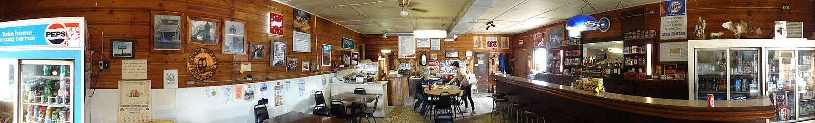
Although the village is nearly abandoned, it does have the 5,000-volume Rudy's Library, founded in memory of Rudy Eiler and maintained by Elsie Eiler. In addition, Elsie runs a tavern in Monowi and draws regular customers from as far as 80 miles away.
Elsie and Rudy's Library were shown on the Today show on May 31, 2005. (The library is now around three times as large as shown in the image).
Elsie and the Monowi Tavern were featured on CBS Sunday Morning on October 29, 2006, and again on August 12, 2007.
Elsie, the village, the tavern, and library were featured on an episode of Only in America with Larry the Cable Guy, where Larry announced on a radio show that he was having a hotdog roast that very day to help raise money for Elsie's village. Within an hour people began to arrive and over a thousand people showed up for the roast to help Elsie. It aired April 12 and May 7, 2011, on The History Channel.
Elsie and the village were featured in a story on "Great Big Story" about tiny cities.
Geography
According to the United States Census Bureau, the village has a total area of 0.21 square miles (0.54 km2), all of it land.[17] The village is located in the far eastern portion of Boyd County, in the northeastern region of Nebraska. It is located between the Niobrara River and the larger Missouri River.[18] The nearest community to Monowi is Lynch, located approximately 6.92 miles (11.14 km) away.[19][20] The village is located approximately 193.97 miles (312.16 km) from Omaha.[19][21]
Demographics
Census data for Monowi highlight its uniqueness. As of 2010:[1]
- The total population was 1 (76.5 years old, female, White).
- There was 1 householder, who was a householder living alone, and the average household size was 1.00.
- Of the 3 housing units in Monowi, only 1 was occupied.
Education
The area is zoned to Lynch Public Schools in Lynch.[22]
See also
- PhinDeli Town Buford, Wyoming – an unincorporated community with only 1 person
- Hibberts Gore, Maine – another town with only 1 person
References
- 1 2 "American FactFinder". United States Census Bureau. Retrieved 2012-06-24.
- ↑ "Population Estimates". United States Census Bureau. Retrieved 2013-05-29.
- ↑ "American FactFinder". United States Census Bureau. Retrieved 2008-01-31.
- ↑ "US Board on Geographic Names". United States Geological Survey. 2007-10-25. Retrieved 2008-01-31.
- ↑ US Census Bureau. "American FactFinder". Retrieved 2011-04-13.
- ↑ Reuters, Monowi, Nebraska, Population: 1.
- ↑ Bright, William (2004). Native American Placenames of the United States. Norman, OK: University of Oklahoma Press. p. 296.
- ↑ Chicago and North Western Railway Company (1908). A History of the Origin of the Place Names Connected with the Chicago & North Western and Chicago, St. Paul, Minneapolis & Omaha Railways. p. 104.
- ↑ Fitzpatrick, Lillian L. (1960). Nebraska Place-Names. University of Nebraska Press. p. 22.
- ↑ "Annual Estimates of the Resident Population for Incorporated Places: April 1, 2010 to July 1, 2015". Retrieved July 2, 2016.
- ↑ United States Census Bureau. "Census of Population and Housing". Retrieved June 23, 2013.
- ↑ "Annual Estimates of the Resident Population: April 1, 2010 to July 1, 2012". Retrieved June 23, 2013.
- ↑ "Monowi , Boyd County". Center for Advanced Land Management Information Technologies. University of Nebraska. Retrieved 30 July 2014.
- ↑ "Boyd County". Jim Forte Postal History. Retrieved 23 March 2015.
- ↑ Macuha, Marhgil. "Elsie Eiler, The Lone Resident of Monowi Town in Nebraska". Batangas Today.
- ↑ Reid, Tim (19 February 2005). "Introducing the mayor of Monowi: (population: 1)". The Times. Retrieved 7 July 2011.(subscription required)
- ↑ "US Gazetteer files 2010". United States Census Bureau. Retrieved 2012-06-24.
- ↑ The Road Atlas (Map) (2009 ed.). 1 inch:23 miles. Cartography by Rand McNally. Rand McNally. 2009. p. 63. § E13-E14.
- 1 2 Michels, Chris (1997). "Latitude/Longitude Distance Calculation". Northern Arizona University. Retrieved October 11, 2012.
- ↑ U.S Board on Geographic Names (March 9, 1979). "Feature Detail Report for: Lynch". Geographic Names Information System. United States Geological Survey. Retrieved October 11, 2012.
- ↑ U.S Board on Geographic Names (March 9, 1979). "Feature Detail Report for: Omaha". Geographic Names Information System. United States Geological Survey. Retrieved October 11, 2012.
- ↑ "Schools in Lynch Public Schools." SchoolDigger. Retrieved on July 21, 2011. See map.
External links
 Media related to Monowi, Nebraska at Wikimedia Commons
Municipalities and communities of Boyd County, Nebraska, United States | ||
|---|---|---|
| Villages | ||
| Townships | ||
| Ghost towns | ||