Moji-ku, Kitakyūshū


Moji-ku (門司区) is a Japanese ward of the city of Kitakyūshū in Fukuoka Prefecture. It is the former city of Moji which was one of five cities merged to create Kitakyūshū in 1963. It faces the city of Shimonoseki across the Kanmon Straits between Honshū and Kyūshū.
The ward's area is 73.37 km² and it has a population of 114,754 as of 2000.
History
Moji was first made into a port by Suematsu Kenchō with the financial backing of Shibusawa Eiichi in 1889. It was chiefly used for the transportation of coal, though there is a traditional song about the sale of bananas imported into Moji from Southeast Asia which survives to this day (Banana no tataki-uri).
An Imperial decree in July 1899 established Moji as an open port for trading with the United States and the United Kingdom.[1]
In 1905, Moji was also the departure point for many troops in the Russo-Japanese War who were ferried across to Korea.
Tourism
The Mojiko Retro District
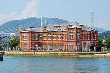
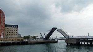
Mojiko Retro, which officially opened under this name as a tourist site in 1995, is a historical area centered on JR Kyushu's Mojiko Station, which is a replica of Rome's Termini Station and is designated an Important Cultural Property of Japan. The area boasts many interesting historic buildings. For instance, the former Moji Mitsui Club once hosted Dr. Albert Einstein and his wife when they visited Japan in the 1920s. Recent developments along the waterfront, such as the renovated customs building, a striking new hotel and a unique pedestrian drawbridge (Blue Wing) add to the charm of Mojiko and make it a pleasant place for visitors to stroll.
Shiranoe Gardens
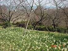
The Shiranoe botanical gardens face out on the Seto Inland Sea.
Transport
Large ferries for Tokyo and Osaka leave from Shin-Moji port on the Seto Inland Sea. Moji Station, a Kyushu Railway Company station on the Kagoshima and Sanyō Main Lines, is also located in the district.
References
External links
- Moji and Shimonoseki
- Moji ward office - official page (Japanese)
- Two large pictures of Mojiko train station.
Coordinates: 33°56′28″N 130°57′35″E / 33.94111°N 130.95972°E