Mohéli
| Autonomous Island of Mohéli Île Autonome de Mohéli Mwali |
||||
|---|---|---|---|---|
|
||||
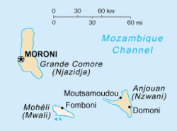 The Comoros islands. Mohéli is the lowermost shown.
|
||||
| Capital and largest city | Fomboni | |||
| Official languages | ||||
| Government | Autonomous island | |||
| • | President | Mohamed Ali Said | ||
| Area | ||||
| • | Total | 211 km2 81 sq mi |
||
| • | Water (%) | negligible | ||
| Population | ||||
| • | 2006 estimate | 38,000 | ||
| • | 2003 census | 35,400 | ||
| • | Density | 122.07/km2 316.2/sq mi |
||
| Currency | Comorian franc (KMF) | |||
| Time zone | EAT (UTC+3) | |||
| • | Summer (DST) | not observed (UTC+3) | ||
| Calling code | +269 | |||
| Internet TLD | .km | |||
| a. | Shimwali dialect. | |||
.svg.png)
Mohéli, also known as Mwali, is one of the three islands which make up the nation of Comoros.
Location
Mohéli is located in the Indian Ocean off the coast of Africa. It is the smallest of the Comoros islands.
Population
Its population, as of 2006, is about 38,000.
Capital
Its capital city is Fomboni.
Ethnic groups
Its main ethnic group, as on the other Comoros islands Grande Comore and Anjouan as well as the French territory Mayotte, is the Comorian ethnic group, a synthesis of Bantu, Arab, Malay and Malagasy culture, and the main religion is Sunni Islam.
History


Until 1830, Mohéli was part of the Ndzuwani Sultanate, which also controlled the neighbouring island of Anjouan. In 1830, migrants from Madagascar led by Ramanetaka, who later changed his name to Abderemane, took over the island and established the sultanate of Mwali. In 1886, France made the island a protectorate.
Until 1889, Mwali had its own French resident, but the island was then subjugated to the residency of Anjouan. The sultanate was crushed in 1909 when the French annexed the island. French colonial stamps inscribed Mohéli were issued from 1906 to 1912.
Comoros
In 1975, Mohéli agreed to join the Comoros nation, along with Grande Comore and Anjouan. Political, economic and social turmoil affected Mohéli and the Comoros in general.
Independence
On 11 August 1997, Mohéli seceded from the Comoros, a week after Anjouan. Mohéli's secessionist leaders were Said Mohamed Soefu who became President, and Soidri Ahmed, who became Prime Minister.
Rejoining Comoros
Mohéli quietly rejoined Comoros in 1998. In 2002, Mohéli ratified the new Comorian constitution, which provided for a less centralized federal government and more power to the island governments. It helped settle continuing political turmoil on Comoros and continuing secessionism on Anjouan.
Also in 2002, Mohamed Said Fazul was elected President. His supporters won most seats in Mohéli's delegation to Parliament in the legislative elections of 2004.
Protected areas

On 19 April 2001, the first protected area in this country – Mohéli Marine Park – was gazetted. This was the culmination of a unique process by which the local communities in the ten villages around the park boundaries negotiated a collaborative arrangement with the government for the establishment and management of the park.
Not surprisingly therefore, the marine park programme was among the 27 finalists selected from nearly 500 nominations by the Equator Initiative, a partnership between the United Nations Development Programme (UNDP), IUCN, the UN Foundation and four other international groups, to promote community-based initiatives aimed at furthering sustainable development.
See also
Coordinates: 12°15′S 43°45′E / 12.250°S 43.750°E