Misurata (Italian province)
Misurata (Italian province) (Italian: Provincia di Misurata), or even "Misrata province", was one of the provinces of Libya under Italian rule. It was established in 1937 with the official name: "Commissariato Generale Provinciale di Misurata". Much of the area of "Provincia di Misurata" became Misrata District with the independence of Libya after World War II.
Characteristics
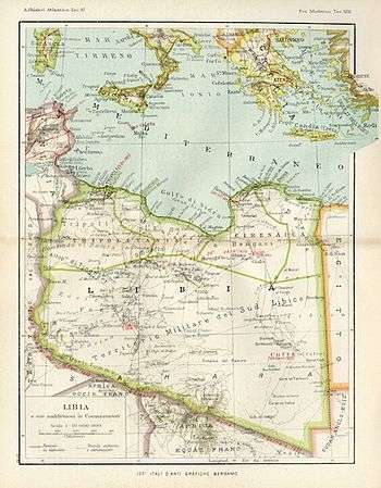
Misurata Province (called even "Misrata Province") was located in northern Italian Libya, between the Tripoli Province and the Bengazi Province. Its administrative center was the small city of Misurata on the Mediterranean coast.
It was divided in three sections ("Circondari" in Italian):
The population in the 1939 Census was of nearly 225,000 inhabitants, most of which were Arabs and Berbers. The Italians were nearly 10,000 and were concentrated in Misurata, Homs and some newly created villages [1] for Italian colonists (Gioda, Crispi, Littoriano, Corradini, etc.[2])
Most of the population was Muslim, but there was a growing community of Catholics due to the Italian colonists immigration.[3] Additionally there were nearly one thousand Jews in Misurata.[4]
The province from 1939 was considered officially part of the Kingdom of Italy, with the same laws. It was one of the 4 new Italian provinces of the so-called Quarta Sponda (Fourth Shore) of Mussolini's Greater Italia. Indeed on January 9, 1939, the colony of Italian Libya was incorporated into "metropolitan Italy" and thereafter considered an integral part of the Italian state (the French, in 1848, had incorporated French Algeria in the same manner).
In the coast of the province was built in 1937-1938 a section of the Via Balbia, a road that went from Tripoli and Tunisia's frontier to the border of Egypt.
The car tag for the Italian province of Misurata was MU.[5]
In 1939 was created the Apostolic Prefecture of Misurata, serving the Italian colonists and a few local Berbers converted.
In August 1941 the Italians started to build a new 1040 km railway (with a 1435mm gauge, like the one used in Egypt and Tunisia) between Tripoli and Benghazi, but the war (with the defeat of the Italian Army) stopped the construction the next year. The project was stopped in the fall of 1942, leaving many infrastructures like stations and connection roads already done in the "Provincia di Misurata": the railway Tripoli-Benghazi had ready 18 km while another 7 km were nearly done; furthermore there were 378 km with only the rail basements ready.[6]
Population in the Province of Misurata
According to the 1939 Italian Census of Libya,[7] these were the main population data:
| CITY' | INHABITANTS | ITALIANS | NOTES |
|---|---|---|---|
| Littoriano | 150 pop. | 150 | Italian colonists village, now abandoned |
| Corradini | 420 pop. | 420 | Italian colonist village, built in 1939 |
| Homs | 35,316 pop. | 1,156 | Italians nearly 3% |
| Misurata | 46,321 pop. | 1,472 | Italians 3% |
| Gioda | 1,550 pop. | 1,550 | Italian colonists village, built in 1939 |
| Taworgha | 5,174 pop. | - | village populated mostly by Blacks and a few Berbers |
| Sirte | 15,014 pop. | 303 | Italians 2% |
| Nofaliya | 3,459 pop. | 35 | Italians nearly 1% |
References

- ↑ Video of "Villaggio Crispi"
- ↑ Map of 1940 showing Italian colonial villages in Misurata Province
- ↑ The Catholic church of Misurata
- ↑ Jews in northwestern Italian Libya
- ↑ Italian car tags (in Italian)
- ↑ Francesco Ogliari. Le ferrovie coloniali italiane in Africa p.48-65
- ↑ Guida Breve d'Italia Vol. III-Italia Meridionale e Insulare - Libia, C.T.I., Milano, 1939
See also
- Tripoli Province
- Benghazi Province
- Derna Province
- Military Territory of the South (Italian Libya)
- Italian Libya
- Misrata Governorate
- Apostolic Prefecture of Misurata
- Italian Libyans