Milefortlet 5
| Milefortlet 5 | |
|---|---|
|
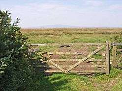
View over the Solway marshes, north of the site of Milefortlet 5 | |
 Location within United Kingdom Cumbria | |
| Type | Milecastle |
| Place in the Roman world | |
| Province | Britannia |
| Location | |
| Coordinates | 54°54′48″N 3°17′44″W / 54.913343°N 3.29555°W |
| County | Cumbria |
| Country | England |
| Reference | |
| UK-OSNG reference | NY17045839 |
Milefortlet 5 (Cardurnock) was a Milefortlet of the Roman Cumbrian Coast defences. These milefortlets and intervening stone watchtowers extended from the western end of Hadrian's Wall, along the Cumbrian coast and were linked by a wooden palisade. They were contemporary with defensive structures on Hadrian's Wall. The remains of Milefortlet 5 was excavated in 1943-4 prior to its destruction in 1944.
Description
Milefortlet 5 was situated in a field just south of the hamlet of Cardurnock in the civil parish of Bowness.[1] The site lies within a disused wartime airfield, now under pasture. There is nothing to see on the ground, but aerial photographs taken in 2006 show the cropmarks of the northern end of the milefortlet.[1]
The coastline to the south is interrupted by Moricambe Bay, and the next known fort is Milefortlet 9. Milefortlets 6, 7 and 8 were once thought to have been eroded by Moricambe, but there is in fact no evidence that the sites ever existed,[2] and the system is believed to begin again with Milefortlet 9.[3]
Excavations
The milefortlet was excavated in 1943-4 prior to the construction of an airfield.[1] Three phases of construction could be traced. Phase 1 dated to the Hadrianic period. Phase 2 dated to the Antonine era, when the size of the milefortlet was reduced.[1] Phase 3 seems to date from the 4th century.[1] In Phase 3 the ramparts were retained but they were refaced on the south, west and north sides, and it seems a stone building in the fortlet was built during this period.[1]
A Roman road has been traced to the southwest of Milefortlet 5, and it was excavated in 1992-3.[4]
Associated Towers
Each milefortlet had two associated towers, similar in construction to the turrets built along Hadrian's Wall. These towers were positioned approximately one-third and two-thirds of a Roman mile to the west of the Milefortlet. However the coastline at this point is interrupted by Moricambe Bay, and any additional towers are purely conjectural.[2]
References
- 1 2 3 4 5 6 Historic England, "Milefortlet 5 (9609)", PastScape, retrieved 26 November 2013
- 1 2 David Colin Arthur Shotter, (1995), The Roman frontier in Britain: Hadrian's Wall, the Antonine Wall, and Roman policy in the north. page 73. Carnegie Pub.
- ↑ John Collingwood Bruce, Charles Daniels (1978), Handbook to the Roman Wall, with the Cumbrian coast and outpost forts, page 34. H. Hill
- ↑ Historic England, "Monument No. 1009473", PastScape, retrieved 26 November 2013
External links
Structures of Hadrian's Wall | ||
|---|---|---|
| Milecastles |  | |
| Milefortlets | ||
| Other structures on Hadrian's Wall | ||
| Regular and linear features | ||