Midway, Ohio
| Midway, Ohio | |
|---|---|
| Village | |
|
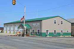
Fire department downtown | |
 Location of Midway, Ohio | |
 Location of Midway in Madison County | |
| Coordinates: 39°43′57″N 83°28′33″W / 39.73250°N 83.47583°WCoordinates: 39°43′57″N 83°28′33″W / 39.73250°N 83.47583°W | |
| Country | United States |
| State | Ohio |
| County | Madison |
| Area[1] | |
| • Total | 0.29 sq mi (0.75 km2) |
| • Land | 0.29 sq mi (0.75 km2) |
| • Water | 0 sq mi (0 km2) |
| Elevation[2] | 1,063 ft (324 m) |
| Population (2010)[3] | |
| • Total | 322 |
| • Estimate (2012[4]) | 322 |
| • Density | 1,110.3/sq mi (428.7/km2) |
| Time zone | Eastern (EST) (UTC-5) |
| • Summer (DST) | EDT (UTC-4) |
| FIPS code | 39-50008[5] |
| GNIS feature ID | 1057845[2] |
Midway (also called Sedalia) is a village in Range Township, Madison County, Ohio, United States. The population was 322 at the 2010 census.
Midway is also called "Sedalia" by some sources.[6] Addresses with its ZIP code, 43151, are officially located in Sedalia.[7]
History
Midway was laid out in 1832 by F. Thompson and William Morris. As of 1875, the community contained two churches, three dry goods stores, one hotel, one blacksmith shop, one wagon shop, one shoe shop, one physician, and the population was 250.[8] The town was named for its location halfway between Philadelphia and Chicago.[9]
Geography
Midway is located at 39°43′57″N 83°28′33″W / 39.73250°N 83.47583°W (39.732474, -83.475870).[10]
According to the United States Census Bureau, the village has a total area of 0.29 square miles (0.75 km2), all land.[1]
Demographics
| Historical population | |||
|---|---|---|---|
| Census | Pop. | %± | |
| 1900 | 274 | — | |
| 1910 | 483 | 76.3% | |
| 1920 | 301 | −37.7% | |
| 1930 | 317 | 5.3% | |
| 1940 | 278 | −12.3% | |
| 1950 | 276 | −0.7% | |
| 1960 | 341 | 23.6% | |
| 1970 | 318 | −6.7% | |
| 1980 | 339 | 6.6% | |
| 1990 | 289 | −14.7% | |
| 2000 | 274 | −5.2% | |
| 2010 | 322 | 17.5% | |
| Est. 2015 | 327 | [11] | 1.6% |
2010 census
As of the census[3] of 2010, there were 322 people, 116 households, and 89 families residing in the village. The population density was 1,110.3 inhabitants per square mile (428.7/km2). There were 127 housing units at an average density of 437.9 per square mile (169.1/km2). The racial makeup of the village was 97.2% White, 0.9% African American, 0.6% Native American, and 1.2% from two or more races. Hispanic or Latino of any race were 3.1% of the population.
There were 116 households of which 43.1% had children under the age of 18 living with them, 48.3% were married couples living together, 19.8% had a female householder with no husband present, 8.6% had a male householder with no wife present, and 23.3% were non-families. 16.4% of all households were made up of individuals and 6.9% had someone living alone who was 65 years of age or older. The average household size was 2.78 and the average family size was 3.04.
The median age in the village was 34.7 years. 30.7% of residents were under the age of 18; 9.9% were between the ages of 18 and 24; 20.8% were from 25 to 44; 26.6% were from 45 to 64; and 11.8% were 65 years of age or older. The gender makeup of the village was 48.8% male and 51.2% female.
2000 census
As of the census[5] of 2000, there were 274 people, 110 households, and 85 families residing in the village. The population density was 984.9 people per square mile (377.8/km²). There were 122 housing units at an average density of 438.5 per square mile (168.2/km²). The racial makeup of the village was 99.64% White, and 0.36% from two or more races. Hispanic or Latino of any race were 1.46% of the population.
There were 110 households out of which 38.2% had children under the age of 18 living with them, 60.9% were married couples living together, 10.0% had a female householder with no husband present, and 22.7% were non-families. 22.7% of all households were made up of individuals and 13.6% had someone living alone who was 65 years of age or older. The average household size was 2.49 and the average family size was 2.91.
In the village the population was spread out with 28.1% under the age of 18, 4.7% from 18 to 24, 24.8% from 25 to 44, 25.9% from 45 to 64, and 16.4% who were 65 years of age or older. The median age was 38 years. For every 100 females there were 91.6 males. For every 100 females age 18 and over, there were 93.1 males.
The median income for a household in the village was $39,464, and the median income for a family was $42,500. Males had a median income of $34,167 versus $25,714 for females. The per capita income for the village was $17,990. About 2.2% of families and 3.0% of the population were below the poverty line, including none of those under the age of eighteen and 10.9% of those sixty five or over.
Notable person
- William V. Allen - former Nebraska Senator
References
- 1 2 "US Gazetteer files 2010". United States Census Bureau. Retrieved 2013-01-06.
- 1 2 "US Board on Geographic Names". United States Geological Survey. 2007-10-25. Retrieved 2008-01-31.
- 1 2 "American FactFinder". United States Census Bureau. Retrieved 2013-01-06.
- ↑ "Population Estimates". United States Census Bureau. Retrieved 2013-06-17.
- 1 2 "American FactFinder". United States Census Bureau. Retrieved 2008-01-31.
- ↑ Midway, Ohio (OH), United States AllRefer.com — Midway, Ohio (OH), United States, Columbia Gazetteer of North America, Columbia University Press, 2000; website 2005. Accessed 2007-10-03.
- ↑ 43151 Zip Code (Midway, Ohio) Detailed Profile, City-data.com, 2007. Accessed 2007-10-03.
- ↑ J. A. Caldwell, Caldwell's Atlas of Madison County, Ohio, Condit, Ohio, 1875, Pg. 10.
- ↑ Peacefull, Leonard (1996). "A Geography of Ohio". Kent State University Press. p. 217. Retrieved 8 December 2013.
- ↑ "US Gazetteer files: 2010, 2000, and 1990". United States Census Bureau. 2011-02-12. Retrieved 2011-04-23.
- ↑ "Annual Estimates of the Resident Population for Incorporated Places: April 1, 2010 to July 1, 2015". Retrieved July 2, 2016.
- ↑ "Census of Population and Housing". Census.gov. Retrieved June 4, 2015.
Municipalities and communities of Madison County, Ohio, United States | ||
|---|---|---|
| City | 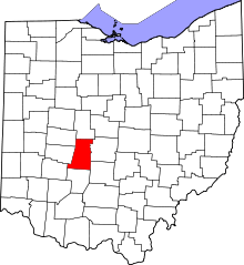 | |
| Villages | ||
| Townships | ||
| CDPs | ||
| Unincorporated communities | ||
| Footnotes | ‡This populated place also has portions in an adjacent county or counties | |