Meuse/Haute Marne Underground Research Laboratory

The Meuse/Haute Marne Underground Research Laboratory is a laboratory located 500 metres underground in Bure in the Meuse département. It allows study of the geological formation in order to evaluate its capacity for deep geological repository of high-level and long-lived medium-level radioactive waste. It is managed by Agence nationale pour la gestion des déchets radioactifs (Andra).
Since radioactive waste needs to be safely stored for extreme lengths of time, the geology of the area is of utmost importance. This site consists of mudstone 500 metres underground in the Paris Basin. It is expected that by 2025, medium-level waste would be stored near Bure.
History
The first practical geological studies on locations for deep geological repository in France date back to the 1960s. In the 1980s Andra, at that time a branch of the CEA, was given the task of investigating possible locations for an underground research laboratory.
Site selection
Two geological formations were initially considered in the 1990s: clay and granite. The 1991 law thus dictated that research would be done in several possible sites.
In 1994, work by Andra investigated a wide range of locations in 4 separate départements, and further narrowed down the choice to 3 locations.
-

Départements under investigation by the 1993 government report
-

Sites selected by Andra in 1994
Layout
All above and below ground facilities at the site are organized around two wells.
Surface installations
There are headframes above each well for transporting equipment and people in and out. Then there is a host of other surface buildings and factories for research, which occupy a total of 170,000 square metres. The reception building has a Green roof.
Tunnels
As of 2007, a 40 metre long tunnel had been completed at the 445 m underground level, while almost 500 m of tunnels have been excavated at the 490 m underground level. Further extensions were built between 2007 and 2009 and more are scheduled, to be completed by 2015.
-

Underground laboratory. Walls are concrete reinforced with a metal frame.
-

Work vehicle.
-
Rock-breaker (in use at the Waste Isolation Pilot Plant).
-

Bolting machine (in use at the Waste Isolation Pilot Plant).
-

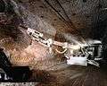
Road header mining machine technology will be implemented in 2007 (e.g. in use at the Waste Isolation Pilot Plant).
Coordinates: 48°29′04″N 5°21′23″E / 48.48444°N 5.35639°E