Merzouga
| Merzouga | |
|---|---|
 | |
 Merzouga Location in Morocco | |
| Coordinates: 31°5′57″N 4°0′42″W / 31.09917°N 4.01167°WCoordinates: 31°5′57″N 4°0′42″W / 31.09917°N 4.01167°W | |
| Country |
|
| Region | Drâa-Tafilalet |
| Province | Errachidia |
| Time zone | WET (UTC+0) |
| • Summer (DST) | WEST (UTC+1) |
Merzouga is a small village in southeastern Morocco, about 35 kilometres southeast of Rissani, about 55 kilometers from Erfoud, and about 50 kilometers from the Algerian border.
The village is known for its proximity to Erg Chebbi, a Saharan erg, and it is for this reason a part of the itineraries of many tourists visiting Morocco. Merzouga has the largest natural underground body of water in Morocco.
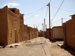
A typical street in the older part of Merzouga
In 2006 Merzouga experienced devastating flash floods, displacing 1,200 and resulting in some deaths.
Near the dunes of Erg Chebbi there are some other known villages: Hassilabied 4 km away, Tanamoust 3 km away, Takoujt 1.5 km away, Khamlia 7 km away and Tisserdmine 15 km away.
External links
| Wikivoyage has a travel guide for Merzouga. |
What to do : Camel Trek ---> CAMEL TREK
This article is issued from Wikipedia - version of the 11/11/2016. The text is available under the Creative Commons Attribution/Share Alike but additional terms may apply for the media files.