Manado
| Manado | ||||||
|---|---|---|---|---|---|---|
| City | ||||||
| Other transcription(s) | ||||||
| • Chinese | 万鸦老 | |||||
| • Pinyin | Wàn yā lǎo | |||||
Clockwise, from top left : Boulevard view, Kalasey Beach, Sam Ratulangi International Airport, Bunaken National Park, Kwan Seng Ta Tie Temple | ||||||
| ||||||
|
Motto: Si Tou Timou Tumou Tou ("Men live to help others live") (Minahasan) | ||||||
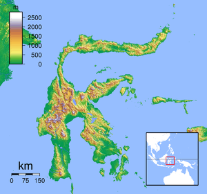 Manado Location of Manado in Sulawesi | ||||||
| Coordinates: 1°29′35″N 124°50′29″E / 1.49306°N 124.84139°E | ||||||
| Country | Indonesia | |||||
| Province | North Sulawesi | |||||
| Founded | 1623 | |||||
| Government | ||||||
| • Mayor | G. S. Vicky Lumentut | |||||
| • Vice Mayor | Mor. D. Bastiaan | |||||
| Area[1] | ||||||
| • Total | 166.87 km2 (64.43 sq mi) | |||||
| Elevation | 5 m (16 ft) | |||||
| Population (2014)[1] | ||||||
| • Total | 430,790 | |||||
| • Density | 2,600/km2 (6,700/sq mi) | |||||
| Time zone | Central Standard Time (UTC+8) | |||||
| Website | kotamanado.go.id | |||||


Coordinates: 1°29′35″N 124°50′28.54″E / 1.49306°N 124.8412611°E
| Manado | |||||||||||||||
| Traditional Chinese | 萬鴉老 | ||||||||||||||
|---|---|---|---|---|---|---|---|---|---|---|---|---|---|---|---|
| Simplified Chinese | 万鸦老 | ||||||||||||||
| |||||||||||||||
Manado (pronounced [maˈnado] in Manado Malay, [məˈnado] in Indonesian, Chinese: 万鸦老; pinyin: Wàn yā lǎo)) is the capital city of the North Sulawesi province of Indonesia. Manado is located at the Bay of Manado,[2] and is surrounded by a mountainous area. The city had 408,354 inhabitants at the 2010 Census,[3] making it the second-largest city in Sulawesi after Makassar. The latest official estimate (for January 2014) is 430,790.
Etymology
The name Manado comes from manadou or wanazou meaning "on the far coast" or "in the distance," which derived from Minahasan Language, and originally referred to the further of two islands which can be seen from the mainland. When the settlement on this island was relocated to the mainland, the name Manado was brought with it, after which the island itself became referred to as Manado Tua ("Old Manado").[4] The name for Manado in Sangir language is Manaro.
History
The first mention of Manado comes from a world map by cartographer Nicolas Desliens, where it showed the island Manarow (today's Manado Tua). Before Europeans arrived to North Sulawesi the area was under the rule of the Sultan of Ternate, who exacted tribute and introduced the Muslim religion among some of its inhabitants. The Portuguese made the Sultan their vassal, taking possession of the Minahasa and established a factory in Wenang.
Meanwhile, the Spanish had already set themselves up in the Philippines and Minahasa was used to plant coffee that came from South America because of its rich soil. Manado was further developed by Spain to become the center of commerce for the Chinese traders who traded the coffee in China. With the help of native allies the Spanish took over the Portuguese fortress in Amurang in the 1550s, and Spanish settlers also established a fort at Manado, so that eventually Spain controlled all of the Minahasa. It was in Manado where one of the first Indo-Eurasian (Mestizo) communities in the archipelago developed during the 16th century.[5] The first King of Manado (1630) named Muntu Untu was in fact the son of a Spanish Mestizo.[6]
Spain renounced to her possessions in Minahasa by means of a treaty with the Portuguese in return for a payment of 350,000 ducats.[7] Minahasan natives made an alliance treaty with the Dutch and expelled the last of the Portuguese from Manado a few years later.

The Dutch East India Company or Verenigde Oost Indische Compagnie (VOC) built a fortress in Manado named Fort Amsterdam in 1658. As with regions in eastern Indonesia, Manado has undergone Christianization by Dutch missionaries, including Riedel and John Gottlieb Schwarz. The Dutch missionaries built the first Christian church in Manado called Oude Kerk (Old church) which still stands and is now called Gereja Sentrum. HMS Dover captured Manado in JUne 1810. The Javanese prince Diponegoro was exiled to Manado by the Dutch government in 1830 for leading a war of rebellion against the Dutch. The English biologist Alfred Wallace visited Manado in 1859, and praised the town for its beauty.
In 1919, the Apostolic Prefecture of Celebes was established in the city. In 1961, it was promoted as the Diocese of Manado.
The Japanese captured Manado in the Battle of Manado in January 1942.[8] The city was heavily damaged by Allied bombing during World War II.
In 1958, the headquarters of the rebel movement Permesta was moved to Manado. When Permesta confronted the central government with demands for political, economic and regional reform, Jakarta responded by bombing the city in February 1958, and then invading in June 1958.
Administration

The city is divided into 11 districts (kecamatan). The table below lists population totals from the 2010 Census. It does not include the districts of Bunaken Kepulauan and Paal 2, which were established in 2012.
| Name | Population Census 2010[9] |
|---|---|
| Malalayang | 54,959 |
| Sario | 23,198 |
| Wanea | 56,962 |
| Wenang | 32,796 |
| Tikala | 69,734 |
| Mapanget | 53,194 |
| Singkil, Sulawesi | 46,721 |
| Tuminting | 52,089 |
| Bunaken | 20,828 |
Transportation

Sam Ratulangi International Airport of Manado is one of the main entry ports to Indonesia. In 2005, no fewer than 15,000 international passengers entered Indonesia via the city's airport. Other public transportation in Manado are:
- Trans Kawanua (BUS)
- Damri Busses serving Airport to Downtown Manado
- Bus serving Tomohon to Manado
Terminal Malalayang or Malalayang Bus Terminal serves as the main gateway for long-distance buses in Manado.
Main sights
Manado is home to some of the biggest and most influential churches in the province, with many of them located along the iconic Sam Ratulangi Street.[10]
Ban Hin Kiong Temple is another popular tourism spot in the city, especially during the Chinese new year celebration.
Other places of interest include nearby Lake Tondano, Lake Linow,[11] Lokon Volcano, Klabat Volcano and Mahawu Volcano, Bukit Kasih ( Hill of Love ) and Watu Pinabetengan
Citraland, a wealthy suburb of Manado, is home to Asia's 2nd tallest and the world's 4th tallest statue of Christ (Christ Blessing Statue), and perhaps the world's first statue in the flying posture.
Tourism
Scuba diving and snorkelling are practised in the nearby Bunaken National Park, including the island of Bunaken.[13][14][15]
Local food tinutuan, or bubur manado, is sold in Wakeke Street, declared by the local government to be an area of culinary tourism.[16]
Manado Boulevard Carnaval (MBC) is a Fashion Carnival at every 16 July inline with Manado City Birthday.[17]
Climate
Manado experiences tropical rainforest climate (Af) according to Köppen Climate Classification as there's no real dry season. The wettest month is January with an annual precipitation of 465 millimetres (18.3 in), while the driest is September with an annual precipitation of 86 millimetres (3.4 in). The abundance of total precipitation seems to be influenced by the monsoon. As its location is near the equator, the temperature seems constant throughout the year. The hottest month is October with an average temperature of 26.4 °C (79.5 °F), while the coolest month is February with an average temperature of 25.2 °C (77.4 °F).[18] Unlike other cities in Indonesia, the temperature seems to be cooler.
| Climate data for Manado, North Sulawesi, Indonesia (1960-1975) | |||||||||||||
|---|---|---|---|---|---|---|---|---|---|---|---|---|---|
| Month | Jan | Feb | Mar | Apr | May | Jun | Jul | Aug | Sep | Oct | Nov | Dec | Year |
| Record high °C (°F) | 32.8 (91) |
33.3 (91.9) |
36.1 (97) |
33.3 (91.9) |
33.3 (91.9) |
33.9 (93) |
36.7 (98.1) |
35.0 (95) |
36.1 (97) |
37.2 (99) |
35.0 (95) |
35.6 (96.1) |
37.2 (99) |
| Average high °C (°F) | 29.2 (84.6) |
29.2 (84.6) |
29.6 (85.3) |
30.6 (87.1) |
31.0 (87.8) |
31.1 (88) |
31.0 (87.8) |
31.6 (88.9) |
32.0 (89.6) |
31.7 (89.1) |
30.6 (87.1) |
29.7 (85.5) |
30.6 (87.1) |
| Daily mean °C (°F) | 25.3 (77.5) |
25.2 (77.4) |
25.3 (77.5) |
25.9 (78.6) |
26.2 (79.2) |
26.0 (78.8) |
26.0 (78.8) |
26.2 (79.2) |
26.3 (79.3) |
26.4 (79.5) |
26.0 (78.8) |
25.6 (78.1) |
25.9 (78.6) |
| Average low °C (°F) | 21.8 (71.2) |
21.7 (71.1) |
21.9 (71.4) |
21.9 (71.4) |
22.1 (71.8) |
21.3 (70.3) |
21.2 (70.2) |
21.2 (70.2) |
21.0 (69.8) |
21.3 (70.3) |
21.7 (71.1) |
21.8 (71.2) |
21.6 (70.9) |
| Record low °C (°F) | 20.0 (68) |
20.0 (68) |
19.4 (66.9) |
18.3 (64.9) |
17.2 (63) |
15.6 (60.1) |
17.8 (64) |
17.2 (63) |
17.8 (64) |
17.8 (64) |
15.0 (59) |
21.1 (70) |
15.0 (59) |
| Average precipitation mm (inches) | 465 (18.31) |
358 (14.09) |
305 (12.01) |
198 (7.8) |
160 (6.3) |
163 (6.42) |
119 (4.69) |
97 (3.82) |
86 (3.39) |
122 (4.8) |
218 (8.58) |
371 (14.61) |
2,662 (104.82) |
| Average precipitation days (≥ 0.1 mm) | 21 | 19 | 17 | 16 | 18 | 16 | 14 | 12 | 12 | 13 | 18 | 21 | 197 |
| Average relative humidity (%) | 86 | 86 | 85 | 85 | 83 | 82 | 78 | 74 | 76 | 80 | 84 | 86 | 82.1 |
| Mean monthly sunshine hours | 167 | 175 | 180 | 231 | 214 | 219 | 242 | 264 | 237 | 217 | 216 | 208 | 2,570 |
| Source #1: Deutscher Wetterdienst[18] | |||||||||||||
| Source #2: Danish Meteorological Institute (sun only)[19] | |||||||||||||
| Jan | Feb | Mar | Apr | May | Jun | Jul | Aug | Sep | Oct | Nov | Dec |
|---|---|---|---|---|---|---|---|---|---|---|---|
| 28 °C (82 °F) | 28 °C (82 °F) | 27 °C (81 °F) | 27 °C (81 °F) | 28 °C (82 °F) | 28 °C (82 °F) | 28 °C (82 °F) | 28 °C (82 °F) | 29 °C (84 °F) | 28 °C (82 °F) | 28 °C (82 °F) | 28 °C (82 °F) |
Sister cities
 Eindhoven, Netherlands
 San Sebastian, Spain
 Cebu, Philippines
- Zamboanga City, Philippines
- Davao, Philippines
 Bristol, United Kingdom
- Liverpool, United Kingdom
 Koror, Palau
 Qingdao, China
 Rio de Janeiro, Brazil
Language
The local language spoken in Manado and the surrounding area is a creole of the Malay language called Manado Malay.
Notable people
- Jahja Daniel Dharma, military leader
- Lilyana Natsir, badminton player and gold medalist at 2016 Summer Olympics
- Firman Utina, soccer player
- Dougy Mandagi, vocalist from The Temper Trap
- Rima Melati, actress
- Marcellino Lefrandt, actor
- Velove Vexia, actress
- Dearly Sompie, singer
References
- 1 2 North Sulawesi in Figures 2013. Badan Pusat Statistik Sulawesi Utara, 2013, p. 52.
- ↑ In the shadows of volcanoes: Manado Bay and its harbour
- ↑ http://www.datastatistik-indonesia.com/component/option,com_tabel/task,/Itemid,165/
- ↑ Willem H. Makaliwe, 1981, A preliminary note on genealogy and intermarriage in the Minahasa regency, North Sulawesi Bijdragen tot de Taal-, Land- en Volkenkunde 137, p. 245
- ↑ Wahr, C.R. Minahasa (history) Website
- ↑ Wahr, C. R. Minahasa (history) Website
- ↑ Milburn, William (1813). Oriental commerce: containing a geographical description of the principal places in the East Indies, China, and Japan, with their produce, manufactures, and trade. New York: Black, Parry & Co. p. 406.
- ↑ L, Klemen (1999–2000). "The Fall of Menado, January 1942". Forgotten Campaign: The Dutch East Indies Campaign 1941–1942.
- ↑ Biro Pusat Statistik, Jakarta, 2011.
- ↑ Great Churches of Manado
- ↑ The lakes of Sulut: Danau Tondano and Linow
- ↑ Christ Blessing and the Waruga
- ↑ Off to Bunaken
- ↑ Livin’ la vida Bunaken’s way
- ↑ Bunaken’s blue, blue seas
- ↑ "Makan Pagi Tinutuan di Wakeke" (in Indonesian). www.kompas.com. 2 April 2010. Retrieved 22 April 2010.
- ↑ http://www.mediaindonesia.com/mediatravelista/index.php/read/2011/07/18/2900/1/Manado-Boulevard-Carnaval-Digelar-Rutin
- 1 2 3 "Klimatafel von Manado / Nord-Celebes (Sulawesi) / Indonesien" (PDF). Federal Ministry of Transport and Digital Infrastructure. Retrieved 8 June 2016.
- ↑ "STATIONSNUMMER 97014" (PDF). Danish Meteorological Institute. Archived from the original on 16 January 2013. Retrieved 8 June 2016.
External links
| Wikimedia Commons has media related to Manado. |
-
 Manado travel guide from Wikivoyage