Meadow Valley Wash
| Meadow Valley Wash | |
| Wash | |
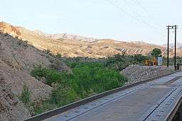 The wash at the Union Pacific gate, north of Moapa | |
| Country | United States |
|---|---|
| State | Nevada |
| Region | Lower Colorado-Lake Mead subregion |
| Counties | Lincoln, Clark |
| Source | |
| - coordinates | 38°11′29″N 114°11′15″W / 38.1913492°N 114.1874827°W [1] |
| Mouth | Muddy River |
| - coordinates | 36°39′50″N 114°34′19″W / 36.6638612°N 114.5719316°WCoordinates: 36°39′50″N 114°34′19″W / 36.6638612°N 114.5719316°W [1] |
| Basin | 2,840 sq mi (7,356 km2) [2] |
| GNIS feature ID HUC |
858091[1] 15010013[3] |
The Meadow Valley Wash is a southern Nevada stream draining the Meadow Watershed that is bordered on 3 sides by the Great Basin Divide. The wash's Lincoln County headpoint is in the Wilson Creek Range, and the wash includes 2 upper confluences (e.g., the Patterson Wash). Panaca is along the upper wash, and downstream of Caliente is the wash's confluence with its east fork. Just prior to the junction with the Muddy River, the wash flows from Lincoln County into northeastern Clark County. It flows into the Muddy in the Moapa Valley just west of Glendale adjacent to Interstate 15 approximately 40 miles (64 km) northwest of Las Vegas.
In addition to the Wilson Creek Range, the watershed's drainage divide is in the Delamar Mountains (to the west) and the Meadow Valley Range (east). The northern tip of the watershed is a triple watershed point with 2 Great Basin subregions, the Central Nevada Desert Basins & the Escalante-Sevier subregion.[3]
History

(Expandable photo in WikiCommons)
William Andrews Clark's 1903-1910 railroad that linked Pioche and Panaca operated through the wash until washed out by flooding.[4]
References
- 1 2 3 "Meadow Valley Wash (GNIS feature ID (858091)". Geographic Names Information System. United States Geological Survey. Retrieved 2010-10-24.
- ↑ "Boundary Descriptions and Names of Regions, Subregions, Accounting Units and Cataloging Units". USGS.gov. Retrieved 2010-10-24.
- 1 2 "Lincoln County" (county & watersheds map with url list). Surf Your Watershed. Retrieved 2010-10-25.
- ↑ "Lincoln County's Fasinating [sic] Past". Discover Nevada. 8NewsNow.com. Retrieved 2010-10-24.
Pioche and Panaca ... were settled by Mormons. The railroad that William Clark brought to Caliente in 1903 linked the towns together. He eventually brought the same line to Las Vegas. ... the Meadow Valley Wash flooded in 1910, water swept through Caliente and washed out miles of railroad track