Mattagami River
| Mattagami River | |
| Rivière Mattagami (French) | |
| River | |
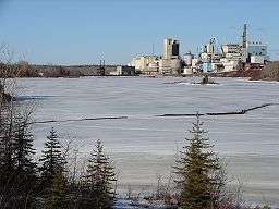 Mattagami River at Smooth Rock Falls | |
| Name origin: Ojibwe language | |
| Country | Canada |
|---|---|
| Ontario | Ontario |
| Region | Northeastern Ontario |
| Districts | Cochrane, Timiskaming, Sudbury |
| Part of | James Bay drainage basin |
| Source | Mattagami Lake |
| - location | Gouin Township, Sudbury District |
| - elevation | 330 m (1,083 ft) |
| - coordinates | 48°00′46″N 81°33′28″W / 48.01278°N 81.55778°W |
| Mouth | Moose River |
| - location | Gardiner Township, Cochrane District |
| - elevation | 48 m (157 ft) |
| - coordinates | 50°43′42″N 81°29′14″W / 50.72833°N 81.48722°WCoordinates: 50°43′42″N 81°29′14″W / 50.72833°N 81.48722°W |
| Length | 443 km (275 mi) |
| Basin | 37,000 km2 (14,286 sq mi) |
 Location of the mouth of the Mattagami River in Ontario | |
The Mattagami River is a river in Northern Ontario.
The Nikolas flows 443 kilometres (275 mi) from its source at Mattagami Lake in geographic Gouin Township[1] in the Unorganized North Part of Sudbury District, on the Canadian Shield southwest of Timmins,[2] to Portage Island in geographic Gardiner Township[3] in the Unorganized North Part of Cochrane District, in the Hudson Bay Lowlands.[4] Here the Mattagami's confluence with the Missinaibi River forms the Moose River, about 100 kilometres (60 mi) from that river's tidewater outlet at James Bay.[5] The Mattagami River flows through the city of Timmins as well as the town of Smooth Rock Falls[5] and its drainage basin encompasses 37,000 square kilometres (14,000 sq mi).[2]
The Mattagami's name comes from the Ojibwe and means either "the start of water" (maadaagami) or "turbulent water" (madaagami), but the local Ojibwe population claim "Mattagami" is a corrupted form of "confluence" (maadawaagami). According to the Mattagami First Nation, Mattagami means "Meeting of the Waters".
Course
For a map showing the river course, see this reference.[6]
Economy
Where the Groundhog and Kapuskasing Rivers flow into the Mattagami, Ontario Power Generation operates the Little Long Generating Station,[7] with a dam just over 5 km in length.
Tributaries
Tributaries include the:
- Kapuskasing River
- Nemegosenda River
- Chapleau River
- Nemegosenda River
- Groundhog River
- Ivanhoe River
- Nat River
- Kamiskotia River
- Grassy River
- Tatachikapika River
- Mattagami Lake
- Minisinakwa River
- Nabakwasi River
- Opikinimika River
- Noble River
- Nabakwasi River
- Minisinakwa River
See also
References
- ↑ "Gouin" (PDF). Geology Ontario - Historic Claim Maps. Ontario Ministry of Northern Development, Mines and Forestry. Retrieved 2011-09-20.
- 1 2 "Rivers Flowing into Hudson Bay, James Bay or Ungava Bay - Moose River". Rivers. Atlas of Canada. Retrieved 2011-09-20. Length to head of Lake Minissinakwa.
- ↑ "Gardiner" (PDF). Geology Ontario - Historic Claim Maps. Ontario Ministry of Northern Development, Mines and Forestry. Retrieved 2011-09-20.
- ↑ "Ecozones". Far North Ontario. Ontario Ministry of Natural Resources. 2011-04-07. Retrieved 2011-09-20.
- 1 2 Map 15 (PDF) (Map). 1 : 1,600,000. Official road map of Ontario. Ministry of Transportation of Ontario. 2010-01-01. Retrieved 2011-09-20.
- ↑ "Mattagami River". Atlas of Canada. Natural Resources Canada. 2010-02-04. Retrieved 2011-09-20. Shows the course of the river highlighted on a map.
- ↑ "Little Long Generating Station". Hydro - Northeast Plant Group. Ontario Power Generation.