Massapequa, New York
| Massapequa, New York | |
|---|---|
| Hamlet and census-designated place | |
| Nickname(s): Pequa | |
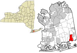 Location in Nassau County and the state of New York. | |
 Location within the state of New York | |
| Coordinates: 40°40′13″N 73°28′6″W / 40.67028°N 73.46833°W | |
| Country | United States |
| State | New York |
| County | Nassau |
| Area | |
| • Total | 4.0 sq mi (10.4 km2) |
| • Land | 3.6 sq mi (9.5 km2) |
| • Water | 0.4 sq mi (1.0 km2) |
| Elevation | 26 ft (8 m) |
| Population (2000) | |
| • Total | 21,685 |
| Time zone | Eastern (EST) (UTC-5) |
| • Summer (DST) | EDT (UTC-4) |
| ZIP code | 11758 |
| Area code(s) | 516 |
| FIPS code | 36-45986 |
| GNIS feature ID | 0956651 |
Massapequa (/mæsəˈpiːkwə/, mass-ə-PEEK-wə) is a hamlet and census-designated place (CDP) in the southern part of the Town of Oyster Bay in southeastern Nassau County, New York, on Long Island, east of New York City. However, it is adjacent to Amityville in Suffolk County. As of the 2010 census, the CDP had a total population of 21,685. In the 1990s the town made national headlines as the hometown of Joey Buttafuoco.
History
A 19th-century writer identified Massapequa as one of the "13 tribes of Long Island," but additional research has shown that they were a band of Lenape, the Algonquian-speaking people who occupied the western part of the island at the time of European encounter. The bands were identified by names of the geographic areas they occupied.
The Native Americans to the east spoke a different Algonquian language and were related to the Pequot people of Connecticut and southern New England, another in the large Algonquian languages family of tribes in coastal areas along the Atlantic Ocean. Major bands of Pequot in eastern Long Island were the Montaukett and Shinnecock. Today the Shinnecock Indian Nation has gained federal recognition and has a reservation on the South Shore of Long Island.
Geography

Massapequa, on the South Shore of Long Island, is located at 40°40'13" North, 73°28'16" West (40.670403, -73.471150).[1]
According to the United States Census Bureau, the CDP has a total area of 4.0 square miles (10 km2), of which, 3.7 square miles (9.6 km2) of it is land and 0.4 square miles (1.0 km2) of it is water. The total area is 9.20% water.
Massapequa and nearby places with "Massapequa" in their names are sometimes collectively called "the Massapequas".[2]
Demographics
As of the census[3] of 2000, there were 22,652 people, 7,417 households, and 6,297 families residing in the CDP. The population density was 6,207.5 per square mile (2,396.2/km²). There were 7,514 housing units at an average density of 2,059.1/sq mi (794.8/km²). The racial makeup of the CDP was 97.42% White, 0.17% African American, 0.02% Native American, 1.27% Asian, 0.03% Pacific Islander, 0.37% from other races, and 0.73% from two or more races. 2.59% of the population were Hispanic or Latino of any race. Because it has large Italian and Jewish communities, the town is sometimes referred to as "matzah pizza".[4][5]
There were 7,417 households out of which 38.3% had children under the age of 18 living with them, 73.4% were married couples living together, 8.5% had a female householder with no husband present, and 15.1% were non-families. 12.5% of all households were made up of individuals and 6.9% have someone living alone who is 65 years of age or older. The average household size was 3.05 and the average family size was 3.33.
In the CDP the population was spread with 25.6% under the age of 18, 5.9% from 18 to 24, 29.5% from 25 to 44, 24.7% from 45 to 64, and 14.3% who are 65 years of age or older. The median age was 41 years as of 2007. For every 100 females there were 94.9 males. For every 100 females age 18 and over, there were 110.0 males.
The median income for a household in the CDP was $107,181, and the median income for a family was $116,266.[6] Males had a median income of $78,859 versus $57,016 for females. The per capita income for the CDP was $42,169. 2.9% of the population and 1.6% of families were below the poverty line.
School district
During the 1960s and the 1970s, Massapequa School District had seven elementary schools (Carman Road, East Lake, Birch Lane, Fairfield, Unqua, Hawthorn, Raymond J. Lockhart), two junior high schools (John P. McKenna and J. Lewis Ames, formerly Parkside) and two high schools, Massapequa and Alfred G. Berner.
A photography book published in late 2014—called Massapequa: A Pictorial History Through The Eyes of Baby Boomers—contains old and current pictures of all these schools and many other sites around town important to the thousands of baby boomers raised in the Pequas.
In the 1990s the Massapequa school district restructured the district by leasing Carmans Road elementary to Nassau BOCES. Hawthorn Elementary was rented to the police department in 2006 and currently serves as the Nassau County Police Academy. John P. McKenna Jr. High School was converted to an elementary school, while Alfred G. Berner became the new middle school. J. Lewis Ames Jr. High School is also no longer a middle school, but now the "Ames Campus" of Massapequa High School, which is where the ninth grade currently attends.
Massapequa School District currently has:
- Six elementary schools (Grades K-6)
- Birch Lane
- East Lake
- Fairfield
- Lockhart
- Unqua
- McKenna
- One middle school (grades 7-8)
- Berner middle school (formerly Berner High School 1962–1987)
- One high school annex (Grade 9)
- Ames
- One high school (Grades 10-12)
Weather
Massapequa has a climate that is very similar to other coastal areas of the Northeastern United States; it has warm, humid summers and cold winters, but the Atlantic Ocean helps bring afternoon sea breezes that temper the heat in the warmer months and limit the frequency and severity of thunderstorms. However, severe thunderstorms are not uncommon, especially when they approach the island from the mainland (Bronx, Westchester and Connecticut) in the northwest. In the wintertime, temperatures are warmer than areas further inland (especially in the night and early morning hours), often causing a snowstorm further inland to fall as rain on the island. However, measurable snowfalls every winter, and in many winters one or more intense storms called Nor'easters may occasionally produce blizzard conditions with snowfalls of 1–2 feet (30–60 cm) and near-hurricane-force winds. Average seasonal snowfall in 28".[7] Long Island temperatures also vary from west to east, with the western part of the island warmer on most occasions than the east. This is due to two factors; one because the western part is closer to the mainland and the other is the western part is more developed causing what is known as the "urban heat island" effect.
On August 25, 2006, a small F0 tornado struck Massapequa.
On Monday, October 29, 2012, Hurricane Sandy devastated much of Massapequa, especially south of Merrick Road where flood waters rose. Schools were closed for several days and many residents remained without power for days, some for weeks after the storm because of uprooted trees and downed power lines.
Notable people
|
|
References
- ↑ "US Gazetteer files: 2010, 2000, and 1990". United States Census Bureau. 2011-02-12. Retrieved 2011-04-23.
- ↑ Historical Society of the Massapequas
- ↑ "American FactFinder". United States Census Bureau. Retrieved 2008-01-31.
- ↑ Schmidt, Catherine (August 3, 1986). "If You're Thinking of Living In; Massapequa". The New York Times. Retrieved April 6, 2016.
- ↑ Harbrecht, Douglas (September 1, 1991). "But Will It Play in Matzo Pizza". Bloomberg. Retrieved April 6, 2016.
- ↑ "Massapequa CDP, New York". United States Census Bureau. Retrieved 2013-03-17.
- ↑ "Weather at New York John F. Kennedy Airport (JFK): Weather and Climate in New York Area, NY, USA".
Coordinates: 40°40′13″N 73°28′16″W / 40.670403°N 73.47115°W