Massacre Rocks State Park
| Massacre Rocks State Park | |
| Idaho State Park | |
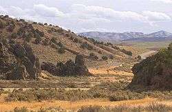
 Boulders in Massacre Rocks State Park deposited during the Bonneville Flood | |
| Country | United States |
|---|---|
| State | Idaho |
| County | Power |
| Location | American Falls |
| - elevation | 4,400 ft (1,341 m) |
| - coordinates | 42°40′43″N 112°59′9″W / 42.67861°N 112.98583°WCoordinates: 42°40′43″N 112°59′9″W / 42.67861°N 112.98583°W |
| Area | 990 acres (401 ha) |
| Founded | 1967 |
| Management | Idaho Department of Parks and Recreation |
| IUCN category | V - Protected Landscape/Seascape |
 Location of Massacre Rocks State Park in Idaho | |
Massacre Rocks State Park is a state park of Idaho, USA, featuring the Massacre Rocks, a famous spot along the Oregon Trail and California Trail during the middle 19th century. The park is located in Power County, along the Snake River west of American Falls.
Description
The park features a famous configuration of boulders along the south bank of the Snake River along the trail, known alternatively as Massacre Rocks, "Gate of Death", or "Devil's Gate". Emigrants gave this name to the narrow passage of the trail through the rocks, from the fear of possible ambush by Native Americans. According to diaries of emigrants, settlers in five wagons clashed with Shoshoni just east of the rocks on August 9–10, 1862. Ten emigrants died in the fight, which involved four wagon trains. The skirmishes took place east of the park and not at Devil's Gate as commonly believed. Some confrontations may have occurred there, but they remain unverified.[1] The Clark Massacre of 1851 occurred just west of Massacre Rocks, closer to the Raft River.
The rocks were often used as campsite for wagon trains along the trail. Many emigrants carved their names and dates on Register Rock, which is now protected by a shelter.[2] The actual passage through the rocks is now the route of Interstate 86 along the south edge of the park.
Geologically the park was created during the repeated volcanic activity on the Snake River Plain. The rocks themselves were deposited in their present location at the end of the last ice age, approximately 14,500 years ago, during the catastrophic flood known as the Bonneville Flood, when much of Lake Bonneville surged down the Snake River.[1] A notch in the cliff on the north bank of the Snake opposite the park was the site of an ancient waterfall of a side channel of the waters in the aftermath of the flood.

The park also includes a visitor center describing the history and geology of the park. It has access to the Snake River, as well as a campground. It is accessible by automobile on Interstate 86. It is also accessible on a foot trail from nearby rest areas just east of the park on Interstate 86. The footpaths also provide access to remnants of the original Oregon Trail on the south side of the highway.[2]
Massacre Rocks became a state park in 1967, having previously been a roadside park managed by the Idaho Department of Transportation.[3]
References
- 1 2 Digital Atlas of Idaho. "Massacre Rocks". Idaho Museum of Natural History. Retrieved 2011-03-05.
- 1 2 Idaho Department of Parks and Recreation. "Massacre Rocks State Park". Retrieved 2011-03-05.
- ↑ "State Lands in Idaho: History". Idaho Museum of Natural History. Retrieved 2011-03-05.