Massachusetts Route 66
| ||||
|---|---|---|---|---|
 | ||||
| Route information | ||||
| Length: | 13.65 mi[1] (21.97 km) | |||
| Major junctions | ||||
| West end: |
| |||
| East end: |
| |||
| Location | ||||
| Counties: | Hampshire | |||
| Highway system | ||||
| ||||

Route 66 is a west–east state highway in Massachusetts.
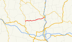
Route 66 begins at Route 112 in the Knightville section of Huntington, just north of US 20. It passes over Norwich Hill into the town of Westhampton, crossing through the southern end of that town into Northampton. It passes through the southwestern part of that town, passing the former Northampton State Hospital and Smith College before ending in front of Smith College at Route 9, just yards west of where that route meets Route 10. For its entire length, Route 66 does not junction any other numbered routes.
Major Intersections
The entire route is in Hampshire County.
| Location | mi[1] | km | Destinations | Notes | |
|---|---|---|---|---|---|
| Huntington | 0.0 | 0.0 | West end of Route 66 | ||
| Westhampton | 5.6 | 9.0 | South Road – Westhampton | ||
| 7.4 | 11.9 | Loudville Road – Easthampton | |||
| Northampton | 13.6 | 21.9 | East end of Route 66 | ||
| 1.000 mi = 1.609 km; 1.000 km = 0.621 mi | |||||
References
- 1 2 "Massachusetts Route Log Applicaton". Massachusetts Department of Transportation. Retrieved September 24, 2016.
External links
This article is issued from Wikipedia - version of the 9/24/2016. The text is available under the Creative Commons Attribution/Share Alike but additional terms may apply for the media files.