Massa (river)
| Massa | |
| River | |
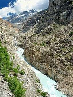 The Massa flows though a steep sided gorge. In the distance is the Aletsch Glacier, which sources the melt-water. | |
| Country | Switzerland |
|---|---|
| Source | Aletsch Glacier |
| - coordinates | 46°26′32″N 8°04′38″E / 46.44222°N 8.07722°E |
| Mouth | |
| - coordinates | 46°22′22″N 8°0′10″E / 46.37278°N 8.00278°ECoordinates: 46°22′22″N 8°0′10″E / 46.37278°N 8.00278°E |
| Length | 7 km (4 mi) |
The Massa is a seven kilometre long river in the eastern Bernese Alps in the Swiss canton of Valais. It is mainly fed by the melt-water from the Aletsch Glacier. It passes through the Massa Gorge and flows into the Stausee Gibidum reservoir and onwards to its confluence with the Rhone.
The whole area, including other glaciers is part of the Jungfrau-Aletsch Protected Area, which was declared a UNESCO World Heritage site in 2001.
See also
| Wikimedia Commons has media related to Massa (river). |
References
This article is issued from Wikipedia - version of the 6/13/2016. The text is available under the Creative Commons Attribution/Share Alike but additional terms may apply for the media files.