Maryland Route 561
| ||||
|---|---|---|---|---|
| Hassengers Corner Road | ||||
|
Maryland Route 561 highlighted in red | ||||
| Route information | ||||
| Maintained by MDSHA | ||||
| Length: | 2.48 mi[1] (3.99 km) | |||
| Existed: | 1933 – present | |||
| Major junctions | ||||
| South end: |
| |||
| North end: |
| |||
| Location | ||||
| Counties: | Kent | |||
| Highway system | ||||
| ||||

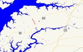
Maryland Route 561 (MD 561) is a state highway in the U.S. state of Maryland. Known as Hassengers Corner Road, the state highway runs 2.48 miles (3.99 km) from MD 213 at Hassengers Corner north to MD 298 in Lynch in central Kent County. MD 561 was constructed in the early 1930s and widened around 1950.
Route description
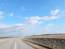
MD 561 begins at an intersection with MD 213 (Augustine Herman Highway) at Hassengers Corner, a crossroads hamlet between Chestertown and Kennedyville. The two-lane highway heads north to the unincorporated village of Lynch, where it intersects the Chestertown Branch of the Northern Line of the Maryland and Delaware Railroad. North of the railroad, MD 561 reaches its northern terminus at MD 298 (Lambs Meadow Road).[1][2]
History
MD 561 was constructed as a macadam road by 1933.[3] The highway was widened and resurfaced in 1949 and 1950.[4]
Junction list
The entire route is in Kent County.
| Location | mi[1] | km | Destinations | Notes | |
|---|---|---|---|---|---|
| Hassengers Corner | 0.00 | 0.00 | Southern terminus | ||
| Lynch | 2.48 | 3.99 | Northern terminus | ||
| 1.000 mi = 1.609 km; 1.000 km = 0.621 mi | |||||
See also
 Maryland Roads portal
References
- 1 2 3 Highway Information Services Division (December 31, 2013). Highway Location Reference. Maryland State Highway Administration. Retrieved 2010-10-11.
- Kent County (PDF)
- ↑ Maryland State Highway Administration (2015). Maryland General Highway Statewide Grid Map (PDF) (Map). 1:12,000. Baltimore: Maryland State Highway Administration. § D15A. Retrieved August 21, 2016.
- ↑ Maryland Geological Survey (1933). Map of Maryland Showing State Road System: State Aid Roads and Improved County Road Connections (Map). Baltimore: Maryland Geological Survey.
- ↑ Maryland Road Construction Progress Log (PDF). Baltimore: Maryland State Highway Administration. Contract Number: K-177X-215 (September 1, 1949). Retrieved August 21, 2016 – via Maryland State Archives.
External links
| Wikimedia Commons has media related to Maryland Route 561. |