Manchester Airport station
| Manchester Airport | |
|---|---|
 | |
| Location | |
| Place | Ringway |
| Local authority | Manchester |
| Grid reference | SJ819853 |
| Operations | |
| Station code | MIA |
| Managed by | TransPennine Express |
| Number of platforms | 4 |
| DfT category | B |
|
Live arrivals/departures, station information and onward connections from National Rail Enquiries | |
| Annual rail passenger usage* | |
| 2010/11 |
|
| 2011/12 |
|
| 2012/13 |
|
| 2013/14 |
|
| 2014/15 |
|
| Passenger Transport Executive | |
| PTE | Transport for Greater Manchester |
| History | |
| May 1993 | Opened |
| 2004 | Refurbished |
| 2008 | Third platform opened |
| 2014 | Metrolink services begin |
| 2015 | Fourth platform added |
| National Rail – UK railway stations | |
| * Annual estimated passenger usage based on sales of tickets in stated financial year(s) which end or originate at Manchester Airport from Office of Rail and Road statistics. Methodology may vary year on year. | |
|
| |
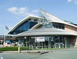
Manchester Airport is a railway station at Manchester Airport, England opening together with a second terminal in 1993. Manchester Metrolink tram services were extended to the Airport in November 2014.
Description
The station is 9 3⁄4 miles (15.7 km) south of Manchester Piccadilly at the end of a short branch from the Styal Line constructed by British Rail in 1993. A branch of Manchester Metrolink runs into it. It is accessed via a triangular junction located between Heald Green and Styal. The station platforms are connected by escalator, elevator, ramps and an elevated covered walkway (known as the "Sky Link") to the airport terminal buildings in which is a manned railway ticket office. Throughout the airport complex, the railway station is known as "The Station" and is signposted as such.
Trains
History
New platforms
In December 2008, a third platform opened after a year of construction and a total cost of £15 million. The following year Network Rail noted that it had "greatly increased operational flexibility at the station, and reduced the number of times that late-running trains had had to be terminated at Manchester Piccadilly."[1]
In 2009, Network Rail stated that the creation of the third platform has meant that the capacity at Manchester Airport will become constrained by the layover of the trains and congestion at the throat. To solve this issue they have recommended building a line underneath the airport towards Northwich in the 2019 to 2024 period.[2]
In July 2012, support for a fourth rail platform was announced by the Government.[3] The current platforms are eight carriage lengths long, so each can accommodate two trains of four carriages. A fourth platform will allow greater use of longer trains of six carriages or more. This had been recommended as part of the Northern Hub scheme of rail improvements around Manchester by the 2010 Manchester Hub Rail Study and the 2011 Northern Route Utilisation Strategy, with an estimated cost of £23 million.[4]
In February 2014, construction commenced on a new £20m fourth platform at the station. The start of construction was attended by the Chancellor of the Exchequer, George Osborne. Construction of the new platform was completed in May 2015 - three years earlier than the 2018 estimate given in 2012.[5][6] This was to allow engineering work to overlap with that being done on the Manchester Metrolink extension to the airport (see below) so that the fourth platform could be used for the extra traffic generated once the Ordsall Chord link is completed, which is currently scheduled for completion in late 2017, while the fourth platform itself opened to passengers in Autumn 2015.[7][8]
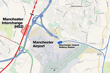
HS2
In January 2013, the Government announced that Manchester Airport would be included in the second phase of the High Speed 2 railway line. This will enable Manchester Airport to be reached from London Euston in 59 minutes. The new line and associated new station will pass to the west of the Airport, away from the existing railway station and transport interchange.[9]
National Rail services
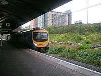
Northern, TransPennine Express and Arriva Trains Wales are the three current franchise holders that serve Manchester Airport. Services between the airport and Crewe (for connections to Southern England); Manchester Piccadilly; various destinations throughout Northern England and, since December 2007, to Glasgow Central and Edinburgh Waverley via Carlisle.
There is a frequent service from the airport to Manchester Piccadilly. Services also operate during the night to Manchester Piccadilly and beyond including York; Doncaster; Sheffield; Scotland and Blackpool North.
There are currently nine trains per hour to Manchester Piccadilly. There are no long distance services to the airport from the south; a Central Trains service from Manchester Airport to Skegness via Derby was cut back to Crewe in 2003.[10]
From May 2016 Arriva Trains Wales have operated an hourly (off peak) Monday - Saturday service to Llandudno via Chester. They now operate 57 services a week compared to the previous 17.
First TransPennine Express used to run the service to Blackpool North but this was passed on to the new Northern franchise in April 2016.
Infrastructure developments that are part of the Northern Hub system of schemes should allow direct trains to Manchester Victoria and on towards Bradford from December 2016.
Manchester Metrolink
| Metrolink | |
|
Metrolink extension plans | |
| Location | |
| Place | Ringway |
| Local authority | City of Manchester |
| Platforms | 2 |
| Fare zone information | |
| Metrolink Zone | S |
| Present status | In operation |
| History | |
| Opened | 3 November 2014 |
|
| |

The Manchester Metrolink light rail network was extended from St Werburgh's Road to Manchester Airport as part of the Phase 3 expansion project.[11] The Metrolink station has been built adjacent to the airport station.[12] It is the terminus of the Airport Line.
_(2).jpg)
Following a period of uncertainty due to funding problems, the plans were finally given the go-ahead in May 2009. The confirmed route will not complete the full airport loop as proposed, but trams will run along the northern route via Wythenshawe. Completion of the western side of the loop would be subject to further funding in a later project.[13][14] An opening date of Summer 2016 had originally been indicated for opening of the Airport line[15] but in June 2014 it was announced that the line would open early on 3 November 2014, and so it did open.[16][17]
Services
Trams run between Manchester Airport and Cornbrook every 12 minutes. An early morning service runs to Firswood from 3–6 am every 20 minutes. When the Second City Crossing opens, services will run through the city centre.[16] The Second City Crossing is currently scheduled to have the first trams running on it in Winter 2015/16 and will be fully complete by 2017.[18][19]
References
- ↑ Connecting local communities: Route Plan 2009 for Route 20 - North West Urban, Network Rail, 2009; page 6
- ↑ Connecting local communities: Route Plan 2009 for Route 20 - North West Urban, Network Rail, 2009; page 27
- ↑ Historic day for Greater Manchester's rail network, Transport for Greater Manchester, 16 July 2012
- ↑ Manchester Hub Rail Study, Network Rail, February 2010
Northern Route Utilisation Strategy, Network Rail, May 2011, page 7 and pp. 55-56 - ↑ "Chancellor unveils the start of £600m rail investment in the north of England". Network Rail. 7 February 2014. Retrieved 2014-04-04.
- ↑ "Manchester Airport station reopens after work to build a fourth platform is completed (news release)". Network Rail. 9 February 2015. Archived from the original on 13 February 2015. Retrieved 13 February 2015.
- ↑ "And then there were 4".
- ↑ "Manchester Airport rail station's fourth platform completed ahead of schedule".
- ↑ https://www.gov.uk/government/uploads/system/uploads/attachment_data/file/69079/hs2-msg-ma0-zz-dr-rt-52805.pdf
- ↑ "Train services to be cut". BBC News. 17 February 2003.
- ↑ "Metrolink Future Network" (PDF). GMPTE. 2006. Retrieved 2008-12-28. - map of the proposed network expansion
- ↑ "Metrolink Network - proposed South Manchester & Manchester Airport extension (map)". GMPTE. 2005. Retrieved 2009-05-21.
- ↑ "Metrolink: back on track?". BBC Manchester. 2009-05-13. Retrieved 2009-05-17.
- ↑ Linton, Deborah (2009-05-13). "£1.4bn transport deal unveiled". Manchester Evening News. Retrieved 2009-05-17.
- ↑ "Airport line". Manchester Metrolink. Transport for Greater Manchester. Retrieved 19 May 2013.
- 1 2 "Trams to Manchester Airport to arrive more than A YEAR early". Transport for Greater Manchester. Retrieved 20 June 2014.
- ↑ "New Metrolink line to Wythenshawe and Manchester Airport to open on November 3 – a year ahead of schedule". Manchester Evening News. 13 October 2014.
- ↑ "Revealed: First glimpse of Manchester Metrolink's Exchange Square stop on Second City Crossing".
- ↑ "Second City Crossing".
External links
| Wikimedia Commons has media related to Manchester Airport station. |
- Train times and station information for Manchester Airport station from National Rail
- TransPennine Express Official web site
- Metrolink airport line extension proposals, TfGM
- Manchester Airport Metrolink station plans
| Preceding station | |
Following station | ||
|---|---|---|---|---|
| Terminus | TransPennine Express TransPennine North West |
Manchester Piccadilly or | ||
| Terminus | TransPennine Express North TransPennine |
Manchester Piccadilly | ||
| Terminus | TransPennine Express South TransPennine |
Manchester Piccadilly or | ||
| Terminus | Northern Electrics Liverpool Lime Street - Manchester Airport |
Manchester Piccadilly | ||
| Terminus | Northern Blackpool North/Barrow-in-Furness/Windermere - Manchester Airport |
Heald Green | ||
| Terminus | Northern Manchester Airport - Southport |
Manchester Piccadilly | ||
| Styal | Northern Styal Line |
Heald Green | ||
| Terminus | Arriva Trains Wales North Trains Wales |
East Didsbury | ||
| Preceding station | Following station | |||
| Terminus | Manchester Airport - Cornbrook Line | towards Cornbrook |
||
| Terminus | Manchester Airport - Firswood Line 3am-6am only | towards Firswood |
||
| Under Construction | ||||
| Terminus | Manchester Airport Line | towards Manchester Victoria |
||
| Proposed | ||||
towards | Manchester Airport Line | towards |
||
| Bolton | |
|---|---|
| Bury |
|
| Manchester (Manchester station group in italics) | |
| Oldham | |
| Rochdale | |
| Salford | |
| Stockport | |
| Tameside | |
| Trafford | |
| Wigan | |
† stations on the East Lancashire Railway (heritage)
| |
| Tram stops | 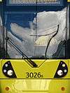  | |||||||||||||||||||||||||||||||
|---|---|---|---|---|---|---|---|---|---|---|---|---|---|---|---|---|---|---|---|---|---|---|---|---|---|---|---|---|---|---|---|---|
| Operations |
| |||||||||||||||||||||||||||||||
| History (Timeline) |
| |||||||||||||||||||||||||||||||
| Proposed stops |
| |||||||||||||||||||||||||||||||
Buildings and structures in Manchester, England | ||
|---|---|---|
| Skyscrapers (over 100 metres) |
|      |
| Highrises (over 50 metres) |
| |
| Notable lowrises (city centre or Grade II* listed) |
| |
| Mills and warehouses |
| |
| Religious (Grade I or II* listed) |
| |
| Transportation | ||
| Entertainment | ||
| Sports venues | ||
| Memorials and sculptures | ||
| Bridges | ||
Italics denote building under construction | ||
Coordinates: 53°21′54″N 2°16′23″W / 53.36500°N 2.27306°W