Makarora River
| Makarora River | |
|---|---|
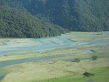
 The Makarora River flows into northern end of Lake Wanaka. | |
| Country | New Zealand |
| Basin | |
| Main source | Mount Aspiring National Park |
| River mouth |
Lake Wanaka 300 m (980 ft) |
| Physical characteristics | |
| Length | 35 km (22 mi) |
The Makarora River is in the Otago region of the South Island of New Zealand.
Geography
The headwaters are in Mount Aspiring National Park, on the eastern flanks of the Southern Alps near Haast Pass, which is the saddle between the Makarora and Haast River valleys. The Makarora River flows south into the northern end of Lake Wanaka after passing the small community of Makarora. The river attracts some recreational fishing, jetboating and kayaking. Rainbow and brown trout migrate from Lake Wanaka up the river and its tributaries to spawn, mainly in autumn and winter.[1]
State Highway 6 follows the Makarora River for the majority of its course from just south of Haast Pass. A popular[2] short walk leads to its confluence with the Blue River, at the aptly named Blue Pools.[3]
Landslide
In September 2007 a landslide in the Young River valley blocked off the corresponding stream. Young River is a tributary to Makarora River. The landslide created a new lake. The lake appears to be permanent.
See also
References
- ↑ Info panel at Blue Pools, Department of Conservation NZ
- ↑ "101 Kiwi Must Do's: The Blue Pools of Haast Pass". NZ Automobile Association. Retrieved 2015-03-22.
- ↑ "Blue Pools Track". Department of Conservation NZ. Retrieved 2015-03-22.
External links
| Wikimedia Commons has media related to Makarora River. |
- http://www.geonet.org.nz/landslide/young-river-landslide/index.html
- http://www.geonet.org.nz/docs/landslide/reports/Young-River-poster-A3.pdf
Coordinates: 44°13′48″S 169°13′34″E / 44.23000°S 169.22611°E