Majuli
| Native name: <span class="nickname" ">মাজুলী | |
|---|---|
|
Doriya River of Majuli. | |
 Mājuli | |
| Geography | |
| Location | Brahmaputra River |
| Coordinates | 26°57′0″N 94°10′0″E / 26.95000°N 94.16667°E |
| Area | 1,250 km2 (480 sq mi) |
| Highest elevation | 84.5 m (277.2 ft) |
| Administration | |
|
India | |
| State | Assam |
| District | Majuli (Formally Declared on 8th September 2016) |
| Demographics | |
| Population | 167,304 Approx (2011) |
| Pop. density | 300 /km2 (800 /sq mi) |
| Ethnic groups |
Mishing, Deori, Sonowal Kacharis minority groups - Ahom, Sutiya, Kalita |
| Additional information | |
| Time zone | |
| PIN | 785102, 785104, 785105, 785110 |
| Telephone code | 03775 |
| Vehicle registration | AS-03 |
| Official website | majulimap.com |

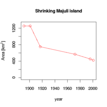
Mājuli or Majoli (pron: ˈmʌʤʊlɪ) (Assamese: মাজুলী, Assamese pronunciation: [mazuli])[1] is the biggest river island in the world[2] in the Brahmaputra River, Assam, India and also 1st island district of the country.[3] The island had a total area of 1,250 square kilometres (483 sq mi) at the beginning of the 20th century,[4] but having lost significantly to erosion it had an area of only 352 square kilometres (136 sq mi) in 2014.[5] Majuli has shrunk as the river surrounding it has grown.[6] However it is recognised by Guinness Book of World Records as World's Largest River Island.[7]
The island is formed by the Brahmaputra river in the south and the Kherkutia Xuti, an anabranch of the Brahmaputra, joined by the Subansiri River in the north. Mājuli island is accessible by ferries from the city of Jorhat. The island is about 300-400 kim east from the state's largest city —Guwahati. It was formed due to course changes by the river Brahmaputra and its tributaries, mainly the Lohit. Mājuli is the abode of the Assamese neo-Vaisnavite culture.[8]
History
Originally, the island was a long, narrow piece of land called Majoli (land in the middle of two parallel rivers) that had the Brahmaputra flowing in the north and the Burhidihing flowing in the south, till they met at Lakhu. Frequent earthquakes in the period 1661–1696 set the stage for a catastrophic flood in 1750 that continued for 15 days, which is mentioned in historical texts and reflected in folklore. As a result of this flood, the Brahmaputra split into two branches — one flowing along the original channel and the other flowing along the Burhidihing channel and the Mājuli island was formed. The Burhidihing's point of confluence moved 190 km east and the southern channel which was the Burhidihing became the Burhi Xuti. The northern channel, which was previously the Brahmaputra, became the Luit Xuti. In due course, the flow in the Luit Xuti decreased, and it came to be known as the Kherkutia Xuti; and the Burhi Xuti expanded via erosion to become the main Brahmaputra River.
The locals speak in the Mising and Assamese languages.
Reference regarding the early existence of Majuli is found in Yogini Tranta that Sutiya king Ratnadhajpal founded his capital in Ratanpur. which is now in the east from kamalabari.[9]
Mājuli has been the cultural capital of Assamese civilisation since the 16th century; based on written records describing the visit of Srimanta Sankardeva — a 16th-century social reformer. Sankardeva, a pioneer of the medieval-age neo-Vaishnavite movement, preached a monotheist form of Hinduism called Vaishnavism and established monasteries and hermitages known as satra on the islet.
The island soon became the leading center of Vaishavinism with the establishment of these satras. After the arrival of the British, Majuli was under the rule of the British until India gained independence in 1947. It is one of world's biggest river islands.
Economy
The main industry is agriculture, with paddy being the chief crop. Mājuli has a rich and diverse agricultural tradition, with as many as 100 varieties of rice grown, all without pesticides or artificial fertilisers. Among the fascinating arrays of rice produced are the Komal Saul, a unique type that can be eaten after immersing the grains in warm water for 15 minutes and usually eaten as a breakfast cereal; the bao dhan, that grows under water and is harvested after ten months; and the Bora saul, a sticky brown rice used to make the traditional cake known as pitha. Fishing, dairying, pottery, handloom and boat-making are other important economic activities.[10]
Handloom is a major occupation among the distaff population of the villages. Although largely a non-commercial occupation, it keeps many of the inhabitants occupied. Weaving is exquisite and intricate with the use of a variety of colours and textures of cotton and silk, especially Muga silk.
People
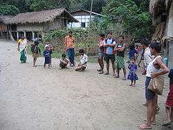

The dwellers of Mājuli are mostly of the Mising tribes from Arunachal Pradesh who immigrated here centuries ago. Apart from them, the inhabitants are from the Deori and Sonowal Kacharis tribes. Languages spoken are Mising, Assamese, and Deori. The island has 144 villages with a population of over 150,000 and a density of 300 individuals per square km. The only mode of association to the outside world is through a ferry service which operates six times a day. Despite inherent drawbacks faced, modernism has touched this island, with the setting up of medical centers and educational institutions. Housing, too, has segued from traditional bamboo and mud construction to ones made of concrete.
The heart of all villages is the Namghar, where villagers episodically gather to sing and pray. It is the most important public place for the villagers. After the rituals are complete, villagers decide on issues concerning the village such as auctioning of fishing rights, what to do with money raised, and other topics of significance to the community as a whole.
The inhabitants are expert navigators by boat; their expertise is most visible during the monsoon season when they navigate the turbulent waters of the Brahmaputra.
Culture

The festival of Ali aye ligang is celebrated during mid-February with great pomp and show. It is celebrated for five days starting from second Wednesday of February till the next week. Local dishes like purang apin (rice wrapped in special leaves), apong (rice beer) and dishes made of pork, fish and chickens are served. Traditional Mising dance Gumrag Soman is performed in every village worshiping the almighty Donyi polo (mother sun and father moon) asking for good year of harvest.
Other festivals like Christmas is celebrated by the majority Christians of Mising tribe in upper Majuli where Jengraimukh village is the epicentre of Christians. Majuli has been the cultural capital and the cradle of Assamese civilization for the past 500 years. The satras set up preserve antiques like weapons, utensils, jewellery and other items of cultural significance. Pottery is made in Mājuli from beaten clay and burnt in driftwood fired kilns in the same mode carried out by the peoples of the ancient Harrappan Civilisation. Sociologists have stressed the preservation of these unique peoples, whose culture and dance forms are untouched by modernism. The hand-loom work of these tribes is internationally famous.
Virtually every person on the island is involved in the three-day long raas festival, depicting the life of Krishna. People from hundreds of kilometers away come to celebrate this festival including a number of expatriate members of community. The satras have honed certain art and craft traditions, which can now be found only here. In Natun Samuguri Satra for example, one can still find the craft of mask-making; and in the Kamalabari Satra the finest boats are made.
Neo-Vaishnavite Satras
The island has been the hub of Assamese neo-Vaishnavite culture, initiated around 15th century by the revered Assamese saint Srimanta Sankardeva and his disciple Madhavdeva. Many Satras or monasteries constructed by the saint still survive and represent the colourful Assamese culture. The saint took refuge in Mājuli and spent a couple of months at Beloguri in West Mājuli, which was a place of grandeur for the historic and auspicious, 'Manikanchan Sanjog' between Shankardeva and Madhavdeva, this was the first satra in Mājuli. After the "Manikanchan Sanjog", sixty five satras were set up. However, today only twenty-two of the original sixty-five are operational. Sixty-five out of the six hundred and sixty-five original satras in Assam were situated in Mājuli.
The main surviving Satras (Satra) are:
- Dakhinpat Satra: Founded by Banamalidev, a supporter of Raasleela, which is now observed as one of the National Festivals of Assam.
- Garamurh Satra: This "Satra" was founded by Lakshmikantadeva. During the end of autumn, the traditional the Raasleela is enacted with pomp and celebrations. Ancient weapons called "Bartop" or cannons are preserved here.
- Auniati Satra: Founded by Niranjan Pathakdeva, the satra is famous for the "Paalnaam" and Apsara Dances and also its extensive assortment of ancient Assamese artefacts, utensils, jewellery and handicrafts. It also has a hundred and twenty five disciples and over seven hundred thousand followers worldwide.
- Kamalabari Satra: The Kamalabari Satra, founded by Bedulapadma Ata, is a centre of art, cultural, literature and classical studies on the island. Its branch the Uttar Kamalabari Satra has performed cultural programmes of the Satria Art all around the country and abroad.
- Benegenaati Satra: It is a reliquary of antiques of cultural importance and an advance centre of performing art. Muraridev, the grandson of Sankaradeva's stepmother was the founder of the Satra. The royal raiment belongs to the Ahom king Swargadeo Godadhar Singha, is made of gold. Also preserved is the royal umbrella made in gold.
- Shamaguri Satra: The satra is famous for the mask making in India.
- Bihimpur satra Satra:.
These satras are the treasure house of "Borgeet" Matiakhara, Satriya Dances (Jumora Dance, Chali Dance, Notua Dance, Nande Vringee, Sutradhar, Ozapali, Apsara Dance, Satria Krishna Dance and Dasavater Dance), all promulgated by Srimanta Sankardeva. It has become a center for shuddhi in the Northeast of India, due to the efforts of Pitambar Deva Goswami.
Photo gallery
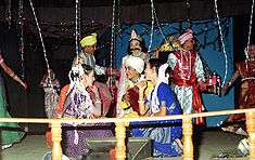
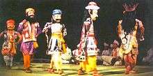
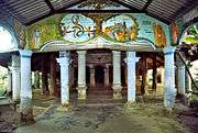 Kamalabari Satra
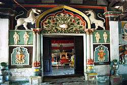 Dakhinpat Satra
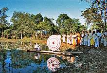 Pooja at Dakhinpat Satra
 From one of the satras
 Aauniati satra gate
Ecosystem
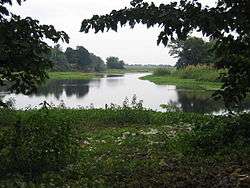
A wetland, Mājuli is a hotspot for flora and fauna, harbouring many rare and endangered avifauna species including migratory birds that arrive in the winter season. Among the birds seen here are the greater adjutant stork, pelican, Siberian crane and the whistling teal. After dark wild geese and ducks fly in flocks to distant destinations. The island is almost pollution free owing to the lack of polluting industries and factories and also the chronic rainfall.
The island is under threat due to the extensive soil erosion on its banks. The reason for this magnitude in erosion is the large embankments built in neighbouring towns upriver to prevent erosion during the monsoon season when the river distends its banks. The upshot is a backlash of the tempestuous Brahmaputra's fury on the islet, eroding most of the area. According to reports, in 1853, the total area of Mājuli was 1,150 km2 and about 33% of this landmass has been eroded in the latter half of 20th century. Since 1991, over 35 villages have been washed away. Surveys show that in 15–20 years from now, Mājuli would cease to exist.
To save the island, the Union Government of India has sanctioned ₹ 250 crores (US $55 million) for the protection of the island. The water resource department & The Brahmaputra Board are struggling to solve the erosion problem of this island for the last three decade but without much success. Recently it was suggested that a four-lane highway protected by concrete mat along the southern boundary of Majuli and excavation of river bed of the Brahmaputra River, only can solve the problem. The project also includes two flood gates for the Kherkatia suti which is a tributary of the Brahmaputra. The Brahmaputra River Restoration Project is yet to be implemented by the government. However, a nomination has been sent to the UNESCO for the declaration of Mājuli to be as a world heritage site.[11]
Local environmental activist Jadav Payeng has planted a 550 hectare forest, known as Molai Forest to combat erosion on the island. Much of the island was barren sandbars that were vulnerable to erosion, but thanks to Payeng's afforestation, has become a lush forest. The forest has become habitat for animals including elephants, tigers, deer, and vultures.[12]
Tourist interests
Mājuli is 20 km from Jorhat. One can take the bus or a hired taxi to the Nimati Steamer Ghat from where ferry services ply. The distance takes over three hours to cover, with three bus rides and two ferry rides.
On the north bank is the river Subansiri and on the south bank, the mighty Brahmaputra has excided the island from the main land. Lakhimpur town is to the north and Golaghat is to its southwest. The town of Sibsagar is on the southeast and Jorhat is to the south. On the extreme east is Dibrugarh District.
- The Vaishnava Satras founded by Sankardeva
- The colourful culture of the tribes
- Migratory birds
- The Ali-ai-ligang festival in Feb-March
- Pottery making
- Mask making
- Paal Namm festival in the end of winter
- Madhya Majuli
- Namoni Majuli
- Ujoni Majuli
- The sunset in winter
- Exotic homespun masks crafts
- the natural beauty.
Birdwatching
The southern part of the island is a bird lover's paradise. The best time to visit is between November to March as the weather and wildlife view is satisfactory. There are three locales for birdwatching:
- The southeast of the island
- The southwest of the island
- The northern part
Educational Institute
Colleges
- Majuli College
- Jengeraimukh College
- Ujoni Majuli Kherkotia Mahavidyalaya
- Rongasahi College
- Pub Majuli College
- Garamur college
Junior Colleges
- Namoni Majuli Junior College
- Pitambar Deva Goswami College
- Majuli Janajati Jr. College.
- Utar Majuli Janajati Jr. College
- ISLAND ACADEMY, kamalabari
- Ratanpur Higher secondary
Schools
- Keshab Ram Borah High school
- Milita Ratanpur Doloni LP School
- Ratanpur Gabhorumelia LP school (Founder Mr Bishwajit Sarmah)
- Ratanpur Highschool
- Mohkhuti Gereki L.P. School
- Gereki Janajati M.E. School
- Island academy
- Jengraimukh High School
- Jengraimuk Girl's High School
- St. Paul's School
- Sri Lohit High School
- Majuli Auniati Hem Chandra High School
- Meragarh Narayandev Higher Secondary School
- Chamaguri Satra Rawanapar [CSR] Model Higher Secondary School [estd.1962]
- N. S. Greenwood English Medium High School
- Mekheligaon Janata Girls' High School
- Karatipar High School, established 1940
- Milonjyoti High School, Totoya Gaon
- Bapuji High school
- RangachahiTanuram Nath high school
- RangachahiTanuram Nath M.E. school
- 208 no Rangachahi Nimno Buniyadi Bidyaloy
- Madhya Majuli Parijat Higher secondary School,Kakotibari gaon.
- Jonaki Chamahiya Ati Higher Secondary School.
- Vivekananda Kendra Vidyalaya Majuli
- Phulani High School
- Phulani ME School
- No. 1 Phulani LP school
- Garamur Sri Sri Pitambor Dev High School
- Chiram High school
- Bhakatiduar Higher Secondary School
- Ratanpur Miri High School
- Chiram Banamalidev Higher Secondary School
- Mudoibil Teliabari Senior basic School
- Major Deori Tribal High School
- Swarnasiri HS.
- Rangachahi Rupjyoti LPS.
- Jamudchuk Lahan HS
- 1 No.Kamalabari L.P
- 2 No.Kamalabari L.P
- 68 No.Namkatoni L.P
- Kamalabari Academy,Dariya
- Kharjanpar Tribel High School
- Jonaki Jatiya Bidyalaya
- No.48 Kakotibari LP school,Kakotibari
- 136 No. Prachin Chamaguri Satra L.P. School
Computer Institute
Politics
Majuli (Vidhan Sabha constituency) falls under the 99 constituency of legislative assembly of Assam. It is a reserved seat for the Scheduled tribes (ST). It is under jurisdiction of Mising Autonomous Council having three constituencies. Rajiv Lochan Pegu [2001-2006 & 2006-2011, 2011- 2016] was MLA (Member of legislative assembly) from Mājuli in Assam Assembly until 2016. He was bearing the portfolio of Minister of State (Ind.), Water Resources Dev., WPT & BC, in the Government of Assam. Sarbananda Sonowal won constituency in Assam Legislative Assembly election, 2016 and presently chief minister of assam.
Mājuli is one of the 9 assembly segments of Lakhimpur Lok Sabha constituency. At present Sarbananda Sonowal (2014-) is the MP (Member of Parliament) from Bharatiya Janata Party. He is currently the Union Minister of State-Independent Charge for Sports & Youth Affairs, Skill Development & Entrepreneurship.[16]
See also
References
- ↑ Official Website
- ↑ "Assam's Majuli to become India's first island district today".
- ↑ Majuli, District (8 September 2016). "World's largest river island, Majuli, becomes India's first island district". FP India. Retrieved 13 September 2016.
- ↑ Sarma, J. N.; Phukan, M. K. (2004-05-03). "Origin and some geomorphological changes of Majuli Island of the Brahmaputra River in Assam, India". Geomorphology. 60 (1–2): 1–19. doi:10.1016/j.geomorph.2003.07.013.
- ↑ Manogya Loiwal (February 18, 2014). "Majuli, world's largest river island is shrinking and sinking". India Today. Retrieved 2016-04-05.
- ↑ 'A Capricious River, an Indian Island’s Lifeline, Now Eats Away at It', April 14, 2013, New York Times
- ↑ Majuli, River Island. "Largest river island". Guinness World Records. Retrieved 6 September 2016.
- ↑ World Heritage Nominee, India-north-east.com
- ↑ http://majulilandscape.gov.in/history.php
- ↑ The Only Govt Jobs updates website open from Majuli
- ↑ http://pib.nic.in/newsite/PrintRelease.aspx?relid=93119
- ↑ Kalita, Jitu. "India Man Plants Forest Bigger Than Central Park to Save His Island". National Geographic. National Geographic Society. Retrieved 24 May 2016.
- ↑ One more Govt Regn Computer education Centre at Majuli
- ↑ One more Govt Regn Computer education Centre at Majuli
- ↑ Majuli cente,Assam School of Internet Marketing
- ↑ "List of Winning Candidates of Assam State in General Election 2014". Election Commission of India.
- Nagchoudhury, Subrata (February 28, 1997). "Majuli: Island On The Ebb". India Today. Archived from the original on 2008-07-09. Retrieved 2008-05-02.
Ribhaba Bharali - Future of Brahmaputra & Majuli Published in Amar Assam a daily news paper in Nov2012. & Brahmaputra River Restoration Project Published in Assamese Pratidin & Amar Assam in October 2012 & Restoration of Majuli published on Assamese Pratidin in June 2013.
External links
| Wikimedia Commons has media related to Majuli. |
-
 Majuli travel guide from Wikivoyage
 - Majuli Conservation: Impact Tourism
- Jadav Payeng's Majuli
- majuli.org maintained by Majuli Island Protection & Development Council (MIPDC)
- Disaster Management plan for 2011-12 for Jorhat district
- India Man Plants Forest Bigger Than Central Park to Save His Island National Geographic award-winning short film aboout one man's lifework planting a forest since 1979 to protect Majuli
| Topics | |
|---|---|
| History | |
| Districts & Divisions |
|
| Geography | |
| Culture | |
| Arts, Literature, Music Cinema |
|
| People | |
| Notable surnames |
|
| Urban centres | |
| |