Maiolo
| Maiolo | |
|---|---|
| Comune | |
| Comune di Maiolo | |
 Maiolo Location of Maiolo in Italy | |
| Coordinates: 43°52′N 12°19′E / 43.867°N 12.317°ECoordinates: 43°52′N 12°19′E / 43.867°N 12.317°E | |
| Country | Italy |
| Region | Emilia-Romagna |
| Province / Metropolitan city | Rimini (RN) |
| Area | |
| • Total | 24.4 km2 (9.4 sq mi) |
| Population (Dec. 2004) | |
| • Total | 807 |
| • Density | 33/km2 (86/sq mi) |
| Time zone | CET (UTC+1) |
| • Summer (DST) | CEST (UTC+2) |
| Postal code | 61010 |
| Dialing code | 0541 |
Maiolo is a comune (municipality) in the Province of Rimini in the Italian region Emilia-Romagna, located about 135 kilometres (84 mi) southeast of Bologna and about 35 kilometres (22 mi) south of Rimini. As of 31 December 2004, it had a population of 807 and an area of 24.4 square kilometres (9.4 sq mi).[1]
Geography
Maiolo borders the following municipalities: Montecopiolo, Novafeltria, Pennabilli, San Leo, Talamello.
History
After the referendum of 17 and 18 December 2006, Maiolo was detached from the Province of Pesaro and Urbino (Marche) to join Emilia-Romagna and the Province of Rimini on 15 August 2009.[2][3]
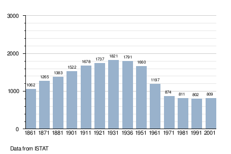
Demographic evolution
References
- ↑ All demographics and other statistics: Italian statistical institute Istat.
- ↑ (Italian) Article about the legislation
- ↑ (Italian) Article on "il Resto del Carlino"
This article is issued from Wikipedia - version of the 1/31/2015. The text is available under the Creative Commons Attribution/Share Alike but additional terms may apply for the media files.