Maidenhead Locator System
The Maidenhead Locator System is a geographic co-ordinate system used by amateur radio operators. Dr. John Morris, G4ANB, originally devised the system, and a group of VHF managers, meeting in Maidenhead, England in 1980, adopted it. The Maidenhead Locator System replaces the older QRA locator system with one that is usable outside Europe.[1]
Maidenhead locators are also commonly referred to as QTH Locator, grid locators or grid squares, despite having a non-square shape on any non-equirectangular cartographic projection. Use of the terms QTH locator and QRA locator was initially discouraged, as it caused confusion with the older QRA locator system. The only abbreviation recommended to indicate a Maidenhead reference in Morse code and radio teleprinter transmission was "LOC", as in "LOC KN28LH".[1]
Description of the system

A Maidenhead locator compresses latitude and longitude into a short string of characters, which is similar in concept to the Georef system. This position information is presented in a limited level of precision to limit the amount of characters needed for its transmission using voice, Morse code, or any other operating mode.[2]
The chosen coding uses alternating pairs of letters and digits, like so:
- BL11bh16
In each pair, the first character encodes longitude and the second character encodes latitude.[3] These character pairs also have traditional names, and in the case of letters, the range of characters (or "encoding base number") used in each pair does vary.
At the 1999 IARU Conference in Lillehammer it was decided that the latitude and longitude to be used as a reference for the determining of locators should be based on the World Geodetic System 1984 (WGS-84).[4] To avoid negative numbers in the input data, the system also specifies that latitude is measured from the South Pole to the North Pole, and longitude measured eastward from the antimeridian of Greenwich, giving the Prime Meridian a false easting of 180° and the equator a false northing of 90°.
To simplify manual encoding, the base for the first pair of letters—traditionally called a field—was chosen to be 18, thus dividing the globe into 18 zones of longitude of 20° each, and 18 zones of latitude 10° each. These zones are encoded with the letters "A" through "R".
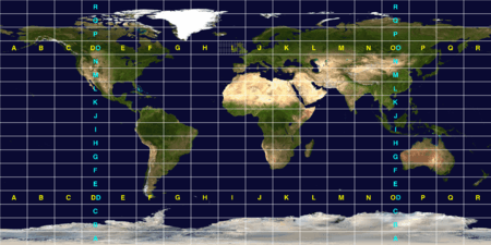
The second pair of numbers, called a square and placed after the first pair of letters, uses a base number of 10, and is encoded using the digits "0" to "9". This is where the alternative name "grid squares" comes from. Each of these squares represents 1° of latitude by 2° of longitude.
For additional precision, each square can optionally be sub-divided further, into subsquares. These are encoded into a second pair of letters, often (but not always) presented in lowercase. Again, to make manual calculations from degrees and minutes easier, 24 was chosen as the base number, giving these subsquares dimensions of 2.5' of latitude by 5' of longitude. The letters used are "a" through "x".
The resulting Maidenhead subsquare locator string is hence composed of two letters, two digits, and two more letters. To give an example, W1AW, the American Radio Relay League's Hiram Percy Maxim Memorial Station in Newington, Connecticut, is found in grid locator FN31pr. Two points within the same Maidenhead subsquare are always less than 12 km apart, which means a Maidenhead locator can give significant precision from just six easily transmissible characters.

For even more precise location mapping, two additional digits were proposed and ratified as an extended locator, making it altogether eight characters long, and dividing subsquares into even smaller ones. Such precision has uses in very short communication spans. Beyond this, no common definition exists to extend the system further into even smaller squares. Most often the extending is done by repeating alternating subsquare and square rules (base numbers 24 and 10 respectively). However, other bases for letter encodings have also been observed, and therefore such extended extended locators might not be compatible.
The Maidenhead locator system has been explicitly based on the WGS 84 geodetic datum since 1999. Before that time, it was usually based on each user's local national datum, which differ slightly from one another and WGS 84. As a result, stations very near the edges of squares at denoted precision may have changed their locators when changing over to the use of WGS 84.
To summarise:
- Character pairs encode longitude first, and then latitude.
- The first pair (a field) encodes with base 18 and the letters "A" to "R".
- The second pair (square) encodes with base 10 and the digits "0" to "9".
- The third pair (subsquare) encodes with base 24 and the letters "a" to "x".
- The fourth pair (extended square) encodes with base 10 and the digits "0" to "9".
- The fifth and subsequent pairs are not formally defined, but recycling the third and fourth pair algorithms is one possible definition:
- BL11bh16oo66
On shortwave frequencies, positions are reported at square precision, and on VHF and UHF, subsquare precision is used. More precise position reports are very rarely used.
Use by radio amateurs
Today, individual radio amateurs and organisations around the world recognise and use Maidenhead locators. Maidenhead locators are used as part of the formulas for scoring in many VHF amateur radio contests. Grid locators are also the basis of earning many awards like the American Radio Relay League's VHF/UHF Century Club, URE TTLOC, etc. operating award.
In IARU Region 1 rules, VHF distance calculations are carried out between Maidenhead subsquare centres assuming a spherical Earth. This results in a small error in distance, but makes calculations simpler and, given the inherent imprecision in the used input data, it is not the biggest error source.
Hardware and software support
In 1985, the Radio Society of Great Britain published a small set of BASIC language routines to convert from locator references to geographical coordinates (latitude and longitude) for further processing.[5] A complete program in BASIC called Universal Gridlocator was made available the following year by ARRL for a nominal cost of US$3.[6] Many other utilities exist to convert latitude and longitude to locators, as this is a favourite hack for programmers who are also radio amateurs. Perl supports conversion between geographical coordinates and Maidenhead locators in module Ham::Locator by Andy Smith, available on CPAN.[7]
Many commercially available general purpose (civil) Global Positioning System (GPS) receivers (e.g. Garmin GPS-12) have the option to display positions in Maidenhead Locator format.[8]
See also
References
- 1 2 R. J. Eckersley, G4FTJ (1985). Amateur Radio Operating Manual (third edition). Potters bar, UK: Radio Society of Great Britain. pp. 64–66. ISBN 0-900612-69-X.
- ↑ Edmund Tyson, N5JTY (January 1989). "Conversion between geodetic and grid locator systems" (PDF). QST. Newington, CT,: The American Radio Relay League: 29–30,43.
- ↑ Bruce Paige, KK5DO (2000). "Maidenhead Grid Squares". AMSAT. Retrieved 10 September 2012.
- ↑ "The Locator System" (PDF). Retrieved 2014-07-13.
- ↑ John Morris, GM4ANB (1985). Amateur Radio Software. Potters Bar, UK: Radio Society of Great Britain. pp. 129–161. ISBN 0-900612-71-1.
- ↑ Wayne Overbeck, N6NB (December 1986). "A Universal Grid-Locator Program for Your Personal Computer". QST. Newington, CT: American Radio Relay League: 30–31.
- ↑ Ham::Locator CPAN module
- ↑ L.A. Burlingame, N7CFO (2010). "GPS Units That Support the Maidenhead Grid System". Retrieved 9 September 2012.
Maps with Maidenhead Locator grid
- ARRL World Grid Locator Atlas, containing all 32,400 Maidenhead Locator Squares. The American Radio Relay League, Inc, Newington, CT, USA, 2007.
- IARU Locator of Europe, The Radio Society of Great Britain, Potters Bar, UK, 1984.
- IARU Locator of Western Europe (scale 1:2,000,000), The Radio Society of Great Britain, Potters Bar, UK, 1985.
- ARRL Amateur Radio Map of North America, The American Radio Relay League, Newington, CT, USA, 2003.
External links
- View full dynamic Maidenhead Locator grid in Google Maps. Click on the 'Position' control in the map area to activate.
- HamRadioIndia: ABC of Grid Locator System
- ARRLWeb: Grid Locators and Grid Squares
- From the field hunter's web page: An explanation of the system and how it came into being.
- Map grid square for any location or amateur radio call sign
- Find QTH locator or Maidenhead grid square, at arbitrary sub-level, and approximate distance, midpoint and bearing between two squares
- Generate a KML file that outlines a grid position
- C# class to convert between geographic coordinates and Maidenhead locators, including distance calculation
- View Maidenhead grid on Google Earth. (Requires login and subscription)