Maiao
| Native name: <span class="nickname" ">Mai'ao | |
|---|---|
|
NASA picture of Mai'ao. | |
 | |
| Geography | |
| Location | Pacific Ocean |
| Coordinates | 17°39′S 150°38′W / 17.650°S 150.633°WCoordinates: 17°39′S 150°38′W / 17.650°S 150.633°W |
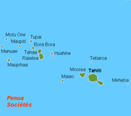
| Archipelago | Society Islands |
| Total islands | 2 |
| Major islands | Maiao |
| Area | 8.8 km2 (3.4 sq mi) |
| Highest elevation | 154 m (505 ft) |
| Administration | |
| Overseas collectivity | French Polynesia |
| Demographics | |
| Population | 299[1] |
| Pop. density | 34 /km2 (88 /sq mi) |

Mai'ao is an 8.8 km2 (3.4 sq mi) island formation located 78 km (48 mi) southwest of Mo'orea and one of the Windward Islands (French: Îles du Vent) in French Polynesia.
Geography
The island formation consists of one high island with a peak elevation of 154 meters (505') and a low island (or motu) that winds along the base of the high island. The formation encloses two hypersaline lagoons called Roto Iti and Roto Rahi. The island also has a lagoon at its edge. All lagoons are connected through narrow channels. The island is home to 299 people (as of Aug. 2007 census).
Administration
The island is administratively part of the commune (municipality) of Mo'orea-Mai'ao, itself in the administrative subdivision of the Windward Islands.
References
- ↑ Institut Statistique de Polynésie Française (ISPF). "TABLEAU II Population des communes et communes associées de Polynésie française" (PDF) (in French). Archived from the original (PDF) on 2008-02-29. Retrieved 2007-12-02.
- Maiao at the Wayback Machine (archived December 23, 2010) at Oceandots.com (accessed June 22, 2006)
- Lesser known Society Islands at colonialvoyage.com (accessed Oct. 22, 2006)] (includes image)
This article is issued from Wikipedia - version of the 12/1/2016. The text is available under the Creative Commons Attribution/Share Alike but additional terms may apply for the media files.