Madang Province
| Madang Province | ||
|---|---|---|
| ||
 Madang Province in Papua New Guinea | ||
| Coordinates: 5°10′S 145°20′E / 5.167°S 145.333°E | ||
| Country | Papua New Guinea | |
| Capital | Madang | |
| Districts | ||
| Government | ||
| • Governor | Jim Kas 2012- | |
| Area | ||
| • Total | 28,886 km2 (11,153 sq mi) | |
| Population (2011 census) | ||
| • Total | 493,906 | |
| • Density | 17/km2 (44/sq mi) | |
| Time zone | AEST (UTC+10) | |

Madang is a province on the northern coast of mainland Papua New Guinea. The province has many of the country's highest peaks, active volcanoes and its biggest mix of languages. The capital is the town of Madang.
History
Human contact with the New Guinea mainland has extended through the past 50,000 years, and scientists have found evidence of human settlement 12,000 to 15,000 years ago near Simbai. In the past 6,000 years sailors ultimately originating from around Taiwan or the Malay Archipelago have traversed this area, leaving their mark in the Austronesian languages which are unevenly distributed along the coastline amongst the Papuan language villages.
The Yabob and Bilbil people used big sailing canoes to trade their pots from Karkar Island to western Morobe. They were part of the Vitiaz Strait trade network. Bundi was the centre of trade between Astrolabe Bay and the Highlands. Trade involved shells, salt, clay pots and wooden bowls from the lowlands and stone axes, feathers and women from the Asaro, Simbu and Jimi valleys.
Geography
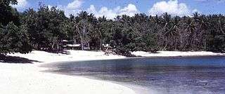
Madang Province is a large region approximately 300 kilometres long and 160 kilometres wide with four large and many small offshore islands. The province totals 29,000 square kilometres and has a population of 365,106 (2000 census).
To the south lies the Bismarck Range with heights ranging over 4,000 metres. Mount Wilhelm, PNG's tallest mountain at 4509m, being found in those ranges. Also in the south, the Ramu Valley separates the Bismarck Range from the Finisterre Range to the south east of the province. The mountains are timber rich with large stands of trees and rainforest, whilst the coastal plain of the vallery is open and studded with palm trees.
The Bismarck Sea laps the northern coast of the region is fed by the larger Ramu, Sogeram, Gogol and Malas Rivers.
Offshore islands in the sea are, in some cases, volcanic, with Karkar, Bagabag and Manam being notable. In 2004/2005 the population of Manam Island was evacuated due to an eruption of the volcano. Bagabag and Karkar have had no major volcanic activities in recent years. This active volcanic region is part of the Pacific Ring of Fire and has created crater lakes, smoking volcanic cones and black sand beaches.
The Madang province receives ample rainfall (3.2 metres in Madang itself) with the months of November to June being the wettest.
People and culture
Due to changes caused by outside contact over the years, cultural loss has been great but isolation of many groups has caused that rate of change to be diversely uneven. Because of the environmental diversity, this province also has a very diverse culture as well. Tall lithe coastal people from Karkar Island, short nuggety highlands men from Simbai and river people from the Ramu.
Many Madang area costumes include bamboo frames decorated with the very common cockatoo and parrot feathers as birds of paradise are relatively uncommon. The Ramu people are prolific carvers and the lower Ramu has cultural links with the villages of the artistically diverse Sepik River region. The resurgence of cultural festivals (i.e. Maborasa Festival) has seen many people donning the dress, feathers and paints of their ancestors.
Foods eaten include those grown in fertile coastal gardens, shellfish and fish, fruit, green vegetables, bananas, taro, sweet potato and yams which relish dry soils. Sago is a staple of the Ramu river people especially in its lower reaches. The mountain people have very good gardens with excellent produce.
Languages
Linguistically, Madang province is typified by a large number of very small language groups, many with fewer than 1,000 people. Austronesian sailors settled on this coast some 5 to 6,000 years ago and the languages of these intrepid but largely unknown sailors are found along the coast of the province. Lukep, Gedaged, Manam and Bilbil languages are examples of this. Inland, the Katiati, Hinihon and Saki and languages are examples of Papuan (non-Austronesian) languages found in the region. The Ramu river languages include Gamei, Giri, Tangu, Romkun and Igana and the Rai Coast languages include Somau Garia and Usino. The volcanic island of Karkar is unusual in that it is shared by the Papuan language Waskia and the Austronesian language Takia.
Economy
The province is the country's third leading producer of cocoa and copra and second producer of cattle. Ramu Sugar, Coconut Oil Production Manang Ltd and Jant/Gogol woodchip mill are amongst PNG's biggest employers. Most areas are still far from transport and undeveloped.
Districts and LLGs
Each province in Papua New Guinea has one or more districts, and each district has one or more Local Level Government (LLG) areas. For census purposes, the LLG areas are subdivided into wards and those into census units.[1]
| District | District Capital | LLG Name |
|---|---|---|
| Bogia District | Bogia (town) | Almami Rural |
| Iabu Rural | ||
| Yawar Rural | ||
| Madang District | Madang | Ambenob Rural |
| Madang Urban | ||
| Transgogol Rural | ||
| Middle Ramu District | Simbai | Arabaka Rural |
| Josephstaal Rural | ||
| Simbai Rural | ||
| Rai Coast District | Rai Coast | Astrolabe Bay Rural |
| Naho Rawa Rural | ||
| Nayudo Rural | ||
| Saidor Rural | ||
| Sumkar District | Karkar | Karkar Rural |
| Sumgilbar Rural | ||
| Usino Bundi District | Usino | Bundi Rural |
| Usino Rural |
Gama Rural
Education
Madang Technical College
Madang Marine Time College
Madang Teachers College
Divine Word University (DWU) is a National University and a leading tertiary institution in Papua New Guinea. Formerly Divine Word Institute, it was established by an Act of Parliament in 1980 and was established as a University in 1996. DWU It is ecumenical, coeducational and privately governed with government support.
References
| Wikivoyage has a travel guide for Madang-Morobe. |