Macgillycuddy's Reeks
| Macgillycuddy's Reeks | |
|---|---|
| Irish: Na Cruacha Dubha | |
 | |
| Highest point | |
| Peak | Carrauntoohil |
| Elevation | 1,038 m (3,406 ft) |
| Dimensions | |
| Length | 19 km (12 mi) |
| Geography | |
| Country | Republic of Ireland |
| Provinces of Ireland | Munster |
| Geology | |
| Age of rock | Devonian |

_-_geograph.org.uk_-_1434441.jpg)

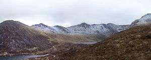
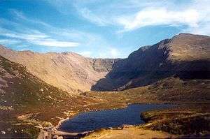
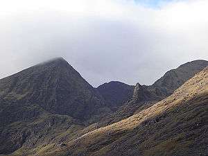
MacGillycuddy's Reeks (Irish: Na Cruacha Dubha, meaning "the black stacks") is a mountain range in County Kerry, Republic of Ireland. Stretching slightly over 19 km (12 mi), it includes the highest peaks in Ireland and the only peaks on the island that are over 1,000 metres (3,300 ft). The highest of these is Carrauntoohil (1,038 m), followed by Beenkeragh (1,010 m) and Caher (1,001 m). The range also includes many other Hewitts (peaks of over 2,000 ft). The mountains, part of the Armorican Highlands, are of glacial-carved Devonian sandstone and are on the Iveragh Peninsula near the Lakes of Killarney.
The name of the range dates to the 18th century. It is derived from the family or clan name Mac Giolla Mochuda (anglicised MacGillycuddy) who are a sept of the O'Sullivan's. The clan chief, McGillycuddy of the Reeks, owned land in this part of Munster for a long time prior, and continued to do so until the end of the 20th century. The word reek is a Hiberno-English version of the English word rick, meaning a stack.
"MacGillycuddy's Reeks" is also the name of a song on Warren Zevon's album My Ride's Here.[1] The song is set on the Iveragh Peninsula and also mentions the "Killarney shore" and Innisfallen. It was co-written by Ulster poet Paul Muldoon.
List of peaks
| # | Peak | Other names | Height |
|---|---|---|---|
| 1 | Corrán Tuathail | Carrauntoohil | 1,038m[2] |
| 2 | Binn Chaorach | Beenkeragh, Benkeeragh | 1,010m[3] |
| 3 | Cathair na Féinne | Caher | 1,001m[4] |
| 4 | Cnoc na Péiste | Knocknapeasta | 988m[5] |
| 5 | Cathair Thiar | Caher West | 975m[6] |
| 6 | Maolán Buí | - | 973m[7] |
| 7 | The Bones | Carrauntoohil Tooth, Knockoughter | 959m[8] |
| 8 | Cnoc an Chuillin | - | 958m[9] |
| 9 | An Gunna Mór | The Big Gun, Lackagarrin, Foilnabreachaun | 939m[10] |
| 10 | Cruach Mhór | - | 932m[11] |
| 11 | Cnoc an Chuillinn Thoir | Cnoc an Chuillinn East | 926m[12] |
| 12 | Cnoc Broinne Thiar | Knockbrinnea West | 854m[13] |
| 13 | Stumpa Bharr na hAbhann | - | 851m[14] |
| 14 | Screig Mhór | Skregmore | 848m[15] |
| 15 | Cnoc Broinne Thoir | Knocnbrinnea East | 847m[16] |
| 16 | Cnoc na Toinne | - | 845m[17] |
| 17 | Cnoc Iochtair | - | 747m[18] |
| 18 | Cnoc an Bhráca | - | 731m[19] |
| 19 | Cnoc na dTarbh | - | 655m[20] |
| 20 | Stumpa an tSaimh/ Stuimpín an Daimh | Hag's Tooth, Stumpeenadaff | 650m[21] |
| 21 | Cnoc Breasail | Brassel | 575m[22] |
| 22 | Screig Bheag | Skregbeg | 573m[23] |
| 23 | Binn Bhán | - | 461m[24] |
| 24 | Binn Dubh | - | 452m[25] |
| 25 | Binn Dhearg | Beendarrig, Bendarrig | 451m[26] |
| 26 | Struicín | Strickeen | 440m[27] |
| 27 | Cnoc Breac | Knockbrack | 425m[28] |
See also
References
- ↑ Billboard 25 May 2002
- ↑ MountainViews
- ↑ MountainViews
- ↑ MountainViews
- ↑ MountainViews
- ↑ MountainViews
- ↑ MountainViews
- ↑ MountainViews
- ↑ MountainViews
- ↑ MountainViews
- ↑ MountainViews
- ↑ MountainViews
- ↑ MountainViews
- ↑ MountainViews
- ↑ MountainViews
- ↑ MountainViews
- ↑ MountainViews
- ↑ MountainViews
- ↑ MountainViews
- ↑ MountainViews
- ↑ MountainViews
- ↑ MountainViews
- ↑ MountainViews
- ↑ MountainViews
- ↑ MountainViews
- ↑ MountainViews
- ↑ MountainViews
- ↑ MountainViews
External links
- McGillycuddy of the Reeks*
- MacGillycuddy's Reeks mountain range Walking Route - Map, Guide and GPS at ActiveMe.ie
Coordinates: 52°01′N 9°42′W / 52.01°N 9.70°W
| Wikimedia Commons has media related to MacGillycuddy's Reeks. |
