M62 motorway
| |
|---|---|
_map.svg.png) | |
| Route information | |
| Maintained by the Highways Agency | |
| Length: |
107 mi[1] (172 km) 7 miles (11 km) are part of the M60 motorway |
| History: | Constructed 1960–76 |
| Major junctions | |
| West end: | Knotty Ash |
|
| |
| East end: | North Cave |
| Location | |
| Counties: | Merseyside, Cheshire, Greater Manchester, West Yorkshire, North Yorkshire, East Riding of Yorkshire |
| Primary destinations: | Liverpool, Warrington, Salford, Manchester, Bradford, Leeds, Wakefield, Hull |
| Road network | |
The M62 is a 107-mile-long (172 km) west–east trans-Pennine motorway in Northern England, connecting Liverpool and Hull via Manchester and Leeds; 7 miles (11 km) of the route is shared with the M60 orbital motorway around Manchester. The road is part of the unsigned Euroroutes E20 (Shannon to Saint Petersburg) and E22 (Holyhead to Ishim).
The motorway, which was first proposed in the 1930s, and conceived as two separate routes, was opened in stages between 1971 and 1976, with construction beginning at Pole Moor and finishing at that time in Tarbock on the outskirts of Liverpool. The motorway absorbed the northern end of the Stretford-Eccles bypass, which was built between 1957 and 1960. Adjusted for inflation to 2007, its construction cost approximately £765 million. The motorway has an average daily traffic flow of 144,000 vehicles in West Yorkshire, and has several areas prone to gridlock, in particular, between Leeds and Huddersfield. The M62 coach bombing of 1974 and the Great Heck rail crash of 2001 are the largest incidents to have occurred on the M62.
Stott Hall Farm, situated between the carriageways on the Pennine section has become one of the best-known sights on the motorway. The M62 has no junctions numbered 1, 2, or 3, or even an officially numbered 4, because it was intended to start in Liverpool proper, not in its outskirts.
Between Liverpool and Manchester, and east of Leeds, the terrain along which the road passes is relatively flat. Between Manchester and Leeds it traverses the Pennines and its foothills, rising to 1,221 feet (372 m) above sea level east of junction 22 in Calderdale, not far from the boundary between Greater Manchester and West Yorkshire.
Planning
The motorway's origins are found in the 1930s, when the need for a route between Lancashire and Yorkshire had been agreed after discussion by their county highway authorities.[2] At the same time, it was envisaged that a route between Liverpool and Hull was needed to connect the ports to industrial Yorkshire.[3]
After the Second World War, the Minister of Transport appointed engineers to inspect road standards between the A580 road (East Lancashire Road) in Swinton and the A1 road near Selby.[3] The 1949 Road Plan for South Lancashire identified the need to upgrade the A580 to dual carriageway with grade separation and provide bypasses at Huyton and Cadishead.[4] In 1952, the route for a trans-Pennine motorway, the Lancashire–Yorkshire Motorway, was laid down, with Ferrybridge at the eastern terminus rather than Selby.[3] By the 1960s, the proposed A580 upgrade to dual carriageway was considered inadequate, and there was an urgent need to link Liverpool to the motorway network.[4] The route of the Lancashire-Yorkshire motorway was considered inadequate as it failed to cater for several industrial towns in Yorkshire.[3] When James Drake visited the United States in 1962, his experience of the Interstate Highway System led him to conclude that the Merseyside Expressway, planned to run between Liverpool and the M6, would need to be extended to the Stretford-Eccles Bypass and beyond, to create a continuous motorway between Liverpool and Ferrybridge (a link between Ferrybridge and Hull was not considered until 1964).[5] Initially the plans were unpopular and not supported by the Ministry of Transport, but the scheme was added to the Road Plan in 1963.[4]
Construction
Liverpool to Worsley
It was the intention to build an urban motorway in Liverpool.[6] The M62 was intended to terminate at Liverpool's Inner Motorway, which was not built. The proposed route would have followed the railway into Liverpool as far as Edge Hill, with junctions at Rathbone Road and Durning Road where it would drop to two lanes before terminating at the Islington Radial.[7] The section between Tarbock and Liverpool was the last to be completed, in 1976, because of difficulties building the urban motorway. In total, two viaducts, ten bridges and seven underpasses were constructed to secure the structural integrity of the surrounding residential areas. The motorway was constructed only as far as Queens Drive (now junction 4).[4]
The section west of Manchester was intended to be a separate motorway, the M52 to link Liverpool and Salford, but a continuous motorway between Leeds and Liverpool was deemed more feasible,[8][9] Construction between Liverpool and Manchester started in 1971, with the construction of a link between the M57 and M6 motorways.[4] Simultaneously, a contract to link the M6 with Manchester was underway, which required land drainage and the removal of unsuitable earth. This section was completed in August 1974, creating a continuous link between Ferrybridge and Tarbock.
In Greater Manchester

Two motorways were planned, the M52 from Liverpool to Salford and the M62 to link Pole Moor with the Stretford–Eccles Bypass.[8] The first part of the M62 to be built was the Stretford–Eccles Bypass, which is now the section between Junctions 7 to 13 of the M60.[10] Construction started in 1957, and the motorway opened in 1960. It was originally built as a 2-lane motorway only. It was later re-numbered M63.[11] The section between the interchange with the Stretford-Eccles Bypass and Salford is now occupied by the M602 motorway.
The Eccles–Pole Moor section opened in 1971.[12][13] Between Eccles and Pole Moor, 67 motorway crossings were required, including seven viaducts and eight junctions.[4] Much of the Worsley Braided Interchange was built on undeveloped mossland where deep peat deposits had been covered with waste. Between Worsley and Milnrow, some underlying coal seams were still actively worked when the motorway was constructed and allowances had to be made to counteract possible future subsidence.[14] The motorway crosses the Irwell Valley and the Pendleton Fault[15] on a 200-foot (61 m) single-span bridge 65 feet (20 m) above the river.[16]
Milnrow to Outlane

Surveying for the Pennine section began in November 1961 and its route was determined in July 1963.[17] Construction between Windy Hill and Pole Moor was difficult through inhospitable hilly terrain, peat bogs, and in undesirable weather conditions. The motorway's highest point, 1,221 feet (372 m) above sea level at Windy Hill near Saddleworth Moor (53°37′47″N 2°01′07″W / 53.62982°N 2.018561°W) is the highest point of any motorway in England.[18]
A notable structure between junctions 21 and 22 on the uphill section towards Windy Hill is the Rakewood Viaduct which carries the road over the Longden End Brook.[19]
The first section of the motorway in Yorkshire was completed between the county boundary at Windy Hill and Outlane in 1970.[1][20] To build this section, 12,000,000 cubic yards (9,200,000 m3) of material was moved, 8,000,000 cubic yards (6,100,000 m3) of which was solid rock and 650,000 cubic yards (500,000 m3) of peat which had to be cut from the rock strata and deposited on adjacent hillsides. The geology of the moors resulted in the engineers splitting the carriageways for 3⁄4 mile (1.2 km) in the middle of this section, sparing Stott Hall Farm from demolition.[20][21]
The motorway crosses Scammonden Dam on an embankment between junctions 22 and 23. Preparatory work in the Deanhead Valley began in August 1964 and the dam in 1966. The motorway's opening on 20 December 1970 was dependent on completion of the dam.[22] Two other notable constructions on the Pennine section are the pedestrian bridge carrying the Pennine Way, which is curved downwards with 85-foot (26 m) long cantilevers, and Scammonden Bridge, the longest single-span non-suspension bridge in the world when it was built.[20][23] It carries a B road 120 feet (37 m) above the motorway.[20] The 1-mile (1.6 km) section between Pole Moor and Outlane suffered fewer problems as the summer weather was satisfactory.[24]

Outlane to Lofthouse
The section of the motorway between Gildersome and Lofthouse was built at the same time, resulting in the demolition of a significant proportion of the village of Tingley to build the eponymous interchange.[1]
East of Lofthouse

Two contracts were awarded for the section between Lofthouse and Ferrybridge in 1972, and both were completed in 1974.[25][26] On the first contract, care was needed at the River Calder crossing due to the alluvial bedrock. On the second contract precautions were taken as the length was built on old coal mine workings.
The section between Ferrybridge and North Cave was the last to be planned[5] and built.[12] The Ouse Bridge, across the River Ouse west of Goole, commenced in January 1973 and is nearly 1 mile (1.6 km) long and rises to 98.4 feet (30.0 m) above ground level. Completion of the bridge was delayed due to "steel supplies [being] a chronic headache" and a partial collapse of the framework caused by bolts joining a cross-beam to a trestle shearing.[5] Problems with the bridge delayed the opening of the section east of Goole to May 1976.[5][12]
Development
_and_M62_interchange.jpg)
In 1987, the Department of Transport proposed a parallel relief road to combat congestion around Manchester. It would have been restricted to long distance traffic, and the current route, part of the Manchester Outer Ring Road (later the M60), used for local traffic. The proposal suggested the closure of junction 13. The proposal was designated a "long term" improvement in 1994, and cancelled on 23 November 1995.[27]
In 2000, the section between Eccles Interchange and Simister Interchange (junctions 12 to 18) was designated the M60.[28] Since then, two junctions were opened—in December 2002, the missing junction 8 was opened to allow access to the A574 and the Omega Development Site,[29] while in January 2006, junction 32a was opened to link to the upgraded A1(M).[30] The UK's first motorway high-occupancy vehicle lane was opened at junction 26 in 2008 for eastbound traffic from the M606 with more than one occupant.[31]
Smart motorway
Pre-2009 proposals to widen the motorway between junctions 25 and 28 to four lanes were withdrawn in January 2009 and replaced by a project to install hard shoulder running and a smart motorway system between junctions 25 and 30.[32] Work started in 2014 to install the system around the M62 - M60 section. [33]
Traffic
The section between junctions 18 (with the M60) and 29 (with the M1) through Greater Manchester and West Yorkshire has been identified as one of the most congested roads in Britain.[34][35] The motorway provides a direct link between two of the ten largest urban areas in England, and is the most practical route for HGVs and other commercial traffic between Manchester and Leeds. There are a significant amount of warehouses in these urban areas, which require commercial delivery to the ports at Merseyside and around the Humber, all of which are transported via the M62.[34]
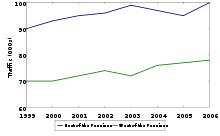
Annual average daily traffic flows of 100,000 cars were recorded east of the Pennines (junction 22) in 2006 and 78,000 cars west of the Pennines.[36] The figures were increases from 90,000 and 70,000 respectively in 1999.[37] By way of comparison, the UK's busiest motorway, the M25 carried 144,000 cars between junctions 7 and 23 in 2006.[36]
Stott Hall Farm
.JPG)
Stott Hall Farm, (53°38′30″N 1°57′08″W / 53.641599°N 1.952222°W) the only farm in the UK situated in the middle of a motorway,[38] was built in the 18th century on Moss Moor. It lies south of Booth Wood Reservoir where the carriageways are separated between junctions 22 and 23.[21][39][40] The road divides for much of its length between the Windy Hill and Deanhead cuttings because of the surrounding geography but a myth [41] persists that it was split because the owners Ken and Beth Wild refused to sell.[39] Sally Boazman, BBC Radio 2's traffic reporter and CB radio users nicknamed it the Little House on the Prairie. It is separated from the motorway by crash barriers and a fence to keep livestock in and prevent out-of-control vehicles crashing onto the property.[21][42] It is one of the ten best-known sights on the motorway network.[43][42] It was the subject of a BBC Radio 4 documentary, a Yorkshire Television documentary[44] and a short film.[45]
Major incidents
On 4 February 1974, a bomb was detonated on a coach travelling between Chain Bar (junction 26) and Gildersome (junction 27). The coach was transporting off-duty army personnel and their family members. Twelve people were killed and 38 were injured. Hartshead Moor services was used as a makeshift hospital and base for investigations.[46] The Provisional Irish Republican Army was deemed responsible.[46][47] A memorial to the victims was erected at Hartshead Moor services in 2009.[48]
The Great Heck rail crash happened on 28 February 2001, at 06:13 after Gary Hart, a sleep-deprived driver, swerved off the M62 onto the East Coast Main Line near Selby. While he was calling the emergency services, a GNER southbound train collided with his Land Rover and derailed into the path of an oncoming goods train. Ten people were killed, including the drivers of both trains, and 82 others were injured.[49]
Route

In addition to passing Warrington, Manchester, Huddersfield, Halifax, Bradford, Leeds and Wakefield, the towns of Huyton, St Helens, Widnes, Bury, Rochdale, Oldham, Dewsbury, Pontefract, Selby and Goole are designated primary destinations along the road. The M62 is a terminus to two motorways: the M57 near Prescot and the M18 near Rawcliffe; and has four spur routes: the M602, which serves Manchester, the A627(M), which serves Oldham and Rochdale, the M606, which serves Bradford, and the M621, which serves Leeds. Despite Hull being listed as a primary destination,[50] the motorway downgrades near North Cave, 16 miles (26 km) to the west.[1][51] The motorway starts at Queen's Drive, on Liverpool's middle ring road from where it runs eastward to the outer ring road, the M57. The route has four exits for Warrington: junction 7, an interchange with the A57 road, junction 8, which also houses IKEA, junction 9, which interchanges with the A49 road, which was intended to be a motorway, and junction 11. Between these is junction 10, which is a cloverstack interchange with the M6. The M62 crosses Chat Moss before interchanging with the M60 motorway. Owing to the original plan to extend this section of the motorway into Manchester, motorists must turn off to stay on (a TOTSO) the route into Yorkshire.
In Greater Manchester, the motorway shares seven junctions, 12 to 18, with the M60 motorway. Junction 13, signposted Swinton, is situated 1⁄2 mile (0.80 km) from junction 12, leaving exiting motorists the hazard of crossing the still-merging M62 traffic.[52] Worsley Braided Interchange serves Junctions 14 and 15 and Junctions 1 to 3 of the M61 which terminates to Preston.

Between junction 21 and junction 22, the motorway has four lanes eastbound to climb Windy Hill,[53] before crossing the border into Yorkshire and interchanging with the rural A672 road, reaching the highest point of any motorway in England 1,221 feet (372 m).[18] There is then a 7-mile (11 km) travel through the Pennines to the next junction, passing Scammonden Reservoir and Stott Hall Farm. The next junction is 23, which is accessible only for westbound traffic. After this, the road dips through a valley to junction 24 and drops slowly before interchanging with the A644 road at junction 25. Between junctions 22 and 25, the road is used as a border between the metropolitan boroughs of Calderdale and Kirklees.[54]
At junction 26, Chain Bar, the motorway interchanges with several roads: the M606, a spur into Bradford, the A58 road, which runs between Prescot and Wetherby, and the A638 road, which runs to Doncaster, then follows the old route of the A1 through Bawtry and Retford, to Markham Moor where it rejoins the A1. The next junction also serves a spur route: the M621 motorway, before bypassing Leeds to the south to the interchange with the M1 motorway, Lofthouse Interchange, at junction 29. East of Leeds, the motorway serves Wakefield at junction 30 and crosses by the River Calder. At junction 32a, the road is crossed by the A1(M) motorway, which also runs parallel to it for a short distance. The next junction serves the A162 road, previously the A1, and Ferrybridge service station. After Ferrybridge, the motorway becomes relatively flat, except for a 1-mile (1.6 km) bridge that crosses the River Ouse. For approximately 10 miles (16 km) after this, the road runs towards Hull, serving Howden and North Cave, before downgrading to the A63 road.
Junctions
Data from driver location signs are used to provide distance and carriageway identifier information.[55][56]
Coordinate list
- ↑ 53°24′22″N 2°53′46″W / 53.405977°N 2.896099°W: Western end of the M62 Motorway
- ↑ 53°25′34″N 2°33′22″W / 53.426024°N 2.55614°W: M6/M62 interchange
- ↑ 53°29′15″N 2°22′36″W / 53.487591°N 2.3767°W: Western end of M60/M62 concurrency
- ↑ 53°32′59″N 2°15′38″W / 53.549801°N 2.26055°W: Eastern end of M60/M62 concurrency
- ↑ 53°44′12″N 1°43′34″W / 53.736671°N 1.726181°W: M62/M606 interchange
- ↑ 53°43′51″N 1°30′43″W / 53.730811°N 1.511929°W: M62/M1 interchange
- ↑ 53°42′40″N 1°17′27″W / 53.711174°N 1.290832°W: M62/A1 interchange
- ↑ 53°41′45″N 1°16′03″W / 53.695714°N 1.267566°W: M62:J33 and Ferrybridge Services
- ↑ 53°46′16″N 0°41′07″W / 53.771087°N 0.685205°W: Eastern end of the M62 Motorway
References
Notes
- 1 2 3 4 Marshall, Chris. "M62 motorway". Motorway Database. Chris's British Road Directory. Retrieved 19 May 2007.
- ↑ "M62: Eccles to County Boundary". The Motorway Archive. Archived from the original on 11 December 2013. Retrieved 19 May 2007.
- 1 2 3 4 "M62 in West Yorkshire". The Motorway Archive. Archived from the original on 21 February 2012. Retrieved 19 May 2007.
- 1 2 3 4 5 6 "M62: Queens Drive to Eccles". The Motorway Archive. Archived from the original on 14 January 2009. Retrieved 19 May 2007.
- 1 2 3 4 "M62: Goole — Ouse Bridge". The Motorway Archive. Archived from the original on 15 May 2008. Retrieved 28 May 2007.
- ↑ David Simmons consultancy. "Case Study:M62 motorway" (PDF). Archived from the original (PDF) on 1 December 2007. Retrieved 30 May 2007.
CEC (1987) estimated that the capital cost of the motorway was "of the order of £412 million at 1985 prices
- ↑ Marshall, Chris. "The Urban M62". Histories — Liverpool Inner Motorway. Chris's British Road Directory. Retrieved 19 November 2007.
- 1 2 "M52 Liverpool to Manchester". Pathetic Motorways. Retrieved 17 October 2015.
- ↑ Marshall, Chris. "M602 Motorway". Motorway Database. Chris's British Road Directory. Retrieved 28 May 2007.
- ↑ "M62 Stretford-Eccles Bypass". Pathetic Motorways. Retrieved 28 May 2007.
- ↑ "M63 (now M60) Stretford-Eccles Bypass and Carrington Spur". The Motorway Archive. Retrieved 28 May 2007.
- 1 2 3 Marshall, Chris. "M62 – Timeline". Motorway Database. Chris's British Road Directory. Retrieved 11 March 2013.
- ↑ Marshall, Chris. "M60 – Timeline". Motorway Database. Chris's British Road Directory. Retrieved 11 March 2013.
- ↑ Johnson 1972, p. 4
- ↑ Johnson 1972, p. 10
- ↑ Johnson 1972, p. 11
- ↑ Johnson 1972, p. 7
- 1 2 "Photo of Highest motorway in England". Panoramio. 19 January 2008. Retrieved 17 August 2009.
- ↑ Johnson 1972, p. 8
- 1 2 3 4 "M62: Boundary to Pole Moor". The Motorway Archive. Archived from the original on 25 January 2009. Retrieved 19 May 2007.
- 1 2 3 "Farming in the fast lane". BBC. 2 February 2007. Retrieved 19 May 2007.
- ↑ "Scammonden Dam". Engineering Timelines. Retrieved 17 October 2015.
- ↑ "Scammonden Water". Scammonden Activity Centre. Archived from the original on 30 July 2013. Retrieved 20 April 2013.
- ↑ "M62: Pole Moor to Outlane". The Motorway Archive. Archived from the original on 31 January 2009. Retrieved 19 May 2007.
- ↑ "M62: Lofthouse to Hopetown". The Motorway Archive. Archived from the original on 8 October 2007. Retrieved 28 May 2007.
- ↑ "M62: Hopetown to Ferrybridge". The Motorway Archive. Archived from the original on 9 May 2008. Retrieved 28 May 2007.
- ↑ "M62 Relief Road". Pathetic Motorways. Retrieved 12 June 2008.
- ↑ Marshall, Chris. "M60". Motorway Database. Chris's British Road Directory. Retrieved 28 May 2007.
- ↑ "M62 junction completion raises region's economic prospects". Costain Group. 2003. Archived from the original on 24 October 2006. Retrieved 5 August 2007.
- ↑ "First car-share lane to be built". BBC News. 20 March 2006. Retrieved 28 May 2007.
- ↑ "M62 J27 to J28 Improvement". Highways Agency. Archived from the original on 17 July 2012. Retrieved 20 October 2011.
- ↑ M62 and M60 see work begin on £208m 'smart motorway' scheme
- 1 2 M62 junctions 18-29 route-based strategy (PDF) (Report). Highways England. March 2013. Retrieved 21 December 2015.
- ↑ "M62 Junctions 24 to 27". In Depth: Traffic Congestion. 2003. Retrieved 30 May 2007.
- 1 2 "Road traffic data tables". Road Statistics 2006: Traffic, Speeds and Congestion. Department for Transport. 26 July 2007. Archived from the original (Microsoft Excel spreadsheet) on 3 November 2014. Retrieved 16 August 2007.
- ↑ "Road Traffic Statistics: 2003". Department for Transport. 12 August 2004. p. 17. Archived from the original (PDF) on 3 November 2014. Retrieved 16 August 2007.
- ↑ Jennings, Ken (21 April 2014). "The Only Farm in the UK in the Middle of a Highway". Condé Nast Traveler. Retrieved 21 December 2015.
- 1 2 "Life in the Fast Lane". BBC West Yorkshire. 24 May 2002. Retrieved 2 August 2007.
- ↑ "Motorways M60 to M69 – Most viewed". Photo gallery. SABRE. Retrieved 2 August 2007.
- ↑ "Farming in the fast lane". BBC Manchester. 2 February 2007. Retrieved 13 October 2016.
- 1 2 "The man in the middle!". 2 November 2006. Retrieved 19 November 2007.
- ↑ "Spaghetti Junction is top sight". BBC West Midlands. 23 August 2007. Retrieved 19 November 2007.
- ↑ Michael Clegg (1983), The Farm on the Motorway
- ↑ Walker, Rowan (30 November 2008). "Farmhouse Island on M62: the Movie". The Observer. London.
- 1 2 "Tragedy on the M62". BBC Bradford. 29 November 2006. Retrieved 30 November 2007.
- ↑ Oliver, Mark (15 January 2002). "Miscarriages of justice". London: Guardian Unlimited. Retrieved 29 May 2007.
- ↑ "M62 Bombing victims remembered". BBC. Retrieved 2 January 2016.
- ↑ "In Depth – Selby train crash". BBC News. 6 January 2003. Retrieved 20 August 2013.
- ↑ Google (20 April 2013). "Streetview – J30 ADS" (Map). Google Maps. Google. Retrieved 20 April 2013.
- ↑ Google (20 April 2013). "Streetview – End of Motorway Sign" (Map). Google Maps. Google. Retrieved 20 April 2013.
- ↑ Marshall, Chris. "M60 Clockwise — Junction 13". Motorway simulator. Chris's British Road Directory. Retrieved 17 November 2007.
- ↑ Google (20 April 2013). "Streetview – lane gain" (Map). Google Maps. Google. Retrieved 20 April 2013.
- ↑ "Waste Management Strategy" (PDF). Calderdale MBC. Retrieved 17 November 2007.
- ↑ M62 Network Schematic showing extents of the Driver Location Signs Scheme within Area 12, Highway Authority 2009
- ↑ Highway Authority (2009). Driver Location Signs, Highway Agency Area 10 (Map). Highway Authority.
Bibliography
- Johnson, E.Peter (1972). The Trans-Pennine Motorway M62. Dalesman. ISBN 0-85206-161-7.
External links

| Great Britain | .svg.png) | |||||||
|---|---|---|---|---|---|---|---|---|
| Northern Ireland | ||||||||
| Former | ||||||||
| Unbuilt | ||||||||
| Proposed | ||||||||
| Related articles | ||||||||
| ||||||||
Transport in Greater Manchester | |||||||||||
|---|---|---|---|---|---|---|---|---|---|---|---|
| Air |  | ||||||||||
| Bus |
| ||||||||||
| Road | |||||||||||
| Tram | |||||||||||
| Cycle | |||||||||||
| Rail |
| ||||||||||
| TIF bid | |||||||||||
See also: Transport in Manchester | |||||||||||