M-31 (Michigan highway)
| ||||
|---|---|---|---|---|
 | ||||
| Route information | ||||
| Length: | 166.910 mi[1] (268.616 km) | |||
| Existed: | c. July 1, 1919[2] – c. November 11, 1926[3] | |||
| Major junctions | ||||
| South end: |
| |||
|
| ||||
| North end: |
| |||
| Location | ||||
| Counties: | St. Clair, Sanilac, Huron, Tuscola, Bay, Saginaw | |||
| Highway system | ||||
| ||||

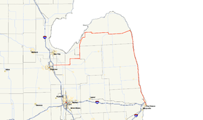
M-31 was a state trunkline highway in the Lower Peninsula in the US state of Michigan. It generally ran north from Port Huron along the Lake Huron shoreline through The Thumb region before turning inland. The highway crossed The Thumb and then ran along the Saginaw Bay shoreline before running inland again, terminating at Saginaw. It was one of the original state highways signposted in 1919, but it was renumbered as other highways in 1926, decommissioning the designation in the process. Parts of its route route are now M-25, M-81 and M-142.
Route description
M-31 started at M-21 in Port Huron and ran northward along the Lake Huron shoreline. Along the way, it intersected the western terminus of M-46 before reaching Harbor Beach. In town, the original M-27 merged in from the north, and M-27/M-31 ran concurrently westward, turning inland. The two highways separated north of Ruth as M-27 turned southward. M-31 continued across The Thumb through Bad Axe, where it ran concurrently with M-19 in town. The highway carried on westward through Elkton and Pigeon to Bay Port. Once there, the trunkline turned southwesterly to follow along part of the Saginaw Bay. The road passed through Sebewaing to Unionville before turning back inland. Running southward to Akron, the highway turned alternately westward and southward to Fairgrove. M-31 next ran west along Bradleyville Road to a connection with M-81; the two highways ran concurrently south through Gilford before M-31 separated and turned back westward through Reese to Saginaw. The northern terminus in downtown Saginaw was at an intersection with what was then M-10.[4]
History
When the state highway system was first signed in 1919,[5] M-31 was one of the original trunklines, originally running northward from Port Huron to Harbor Beach and then westward to Saginaw.[2] When the U.S. Highway System was approved on November 11, 1926,[6] M-31 was decommissioned in favor of alternate numbers. From Port Huron north to Harbor Beach, M-29 was extended as a replacement. The segment west to Bay Port was renumbered M-83 while from Bad Axe west it was also additionally part of M-29 to Unionville. The remainder was numbered M-84 from Unionville to Reese, and M-81 from Reese to Saginaw.[3]
Major intersections
| County | Location | mi[1] | km | Destinations | Notes |
|---|---|---|---|---|---|
| St. Clair | Port Huron | 0.000 | 0.000 | ||
| 4.149 | 6.677 | Southern terminus of original M-27 | |||
| Sanilac | Port Sanilac | 33.486 | 53.890 | Eastern terminus of M-46 | |
| Huron | Harbor Beach | 62.990 | 101.373 | Eastern end of M-27 concurrency | |
| Sand Beach Township | 67.853 | 109.199 | Western end of M-27 concurrency | ||
| Bad Axe | 77.934 | 125.423 | Eastern end of M-19 concurrency | ||
| 80.910 | 130.212 | Northern terminus of M-53 | |||
| Verona Township–Colfax Township line | 82.400 | 132.610 | Western end of M-19 concurrency | ||
| Tuscola | Gilford Township | 147.270 | 237.008 | Northern end of M-81 concurrency | |
| Denmark Township | 152.238 | 245.003 | Southern end of M-81 concurrency | ||
| Bay | Saginaw | 166.910 | 268.616 | ||
1.000 mi = 1.609 km; 1.000 km = 0.621 mi
| |||||
See also
 Michigan Highways portal
References
- 1 2 Michigan Department of Transportation & Michigan Center for Shared Solutions and Technology Partnerships (2009). MDOT Physical Reference Finder Application (Map). Michigan Department of Transportation. Retrieved June 12, 2012.
- 1 2 Michigan State Highway Department (July 1, 1919). State of Michigan (Map). Scale not given. Lansing: Michigan State Highway Department. Lower Peninsula sheet. OCLC 15607244.
- 1 2 Michigan State Highway Department (December 1, 1926). Official Highway Condition Map (Map). [c. 1:823,680]. Lansing: Michigan State Highway Department.
- ↑ Michigan State Highway Department (November 1, 1926). Official Highway Condition Map (Map). [c. 1:823,680]. Lansing: Michigan State Highway Department.
- ↑ "Michigan May Do Well Following Wisconsin's Road Marking System". The Grand Rapids Press. September 20, 1919. p. 10. OCLC 9975013.
- ↑ Bureau of Public Roads & American Association of State Highway Officials (November 11, 1926). United States System of Highways Adopted for Uniform Marking by the American Association of State Highway Officials (Map). 1:7,000,000. Washington, DC: U.S. Geological Survey. OCLC 32889555. Retrieved November 7, 2013 – via University of North Texas Libraries.
External links
- M-31 at Michigan Highways