Mézières-sur-Seine
| Mézières-sur-Seine | |
|---|---|
|
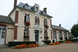
Town hall | |
 Mézières-sur-Seine | |
|
Location within Île-de-France region  Mézières-sur-Seine | |
| Coordinates: 48°57′32″N 1°48′17″E / 48.9589°N 1.8047°ECoordinates: 48°57′32″N 1°48′17″E / 48.9589°N 1.8047°E | |
| Country | France |
| Region | Île-de-France |
| Department | Yvelines |
| Arrondissement | Mantes-la-Jolie |
| Canton | Guerville |
| Government | |
| • Mayor (2001–2008) | Pierre Blévin |
| Area1 | 10.42 km2 (4.02 sq mi) |
| Population (2006)2 | 3,536 |
| • Density | 340/km2 (880/sq mi) |
| Time zone | CET (UTC+1) |
| • Summer (DST) | CEST (UTC+2) |
| INSEE/Postal code | 78402 / 78970 |
| Elevation |
17–156 m (56–512 ft) (avg. 22 m or 72 ft) |
|
1 French Land Register data, which excludes lakes, ponds, glaciers > 1 km² (0.386 sq mi or 247 acres) and river estuaries. 2 Population without double counting: residents of multiple communes (e.g., students and military personnel) only counted once. | |
Mézières-sur-Seine is a commune in the Yvelines department in the Île-de-France in north-central France. It is located in the western suburbs of Paris, near the bank of the Seine 47 km (29 mi) west of Paris.
The name of the commune comes from the Latin word: maceria, meaning walls.
Sites of interest
Saint-Nicolas church, built in the 13th century in Gothic style. A choir was added since the 17th century. It is a listed monument since 1931.
See also
References
| Wikimedia Commons has media related to Mézières-sur-Seine. |
This article is issued from Wikipedia - version of the 11/1/2014. The text is available under the Creative Commons Attribution/Share Alike but additional terms may apply for the media files.