Louisiana Highway 433
| ||||
|---|---|---|---|---|
 | ||||
| Route information | ||||
| Maintained by Louisiana DOTD | ||||
| Length: | 14.8 mi[1] (23.8 km) | |||
| Major junctions | ||||
| West end: |
| |||
|
| ||||
| East end: |
| |||
| Location | ||||
| Parishes: | St. Tammany | |||
| Highway system | ||||
| ||||
.svg.png)
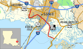
Louisiana Highway 433 (LA 433) is a state highway in Louisiana that serves St. Tammany Parish. It spans 14.8 miles (23.8 km) in a west to east direction. It is known at various points as Thompson Road, Bayou Liberty Road, Pontchartrain Drive, Old Spanish Trail, and Rigolets Road.
Route description
From the west, LA 433 begins at a junction with U.S. Route 190 (US 190) near the North Shore Mall and heads south. At this point, the roadway is also known as Thompson Road. After about two miles (3.2 km), the road crosses Bayou Liberty and turns eastward, becoming Bayou Liberty Road. As the road nears downtown Slidell, it crosses Bayou Bonfouca via a drawbridge and becomes a four-lane divided highway. Shortly thereafter, the road joins US 11 and heads southward for about a quarter of a mile before departing eastward along the Old Spanish Trail. LA 433 then intersects Interstate 10 via a diamond interchange (exit 263). Afterward it narrows to two lanes and winds through the swamps of southeast St. Tammany Parish. Heading southeastward, the highway is duly known as Rigolets Road and the Old Spanish Trail at this point. LA 433 ends at a junction with US 90 just north of the Rigolets.
LA 433 is an undivided, two-lane highway from US 190 to US 11. The route then widens to an undivided, five-lane roadway (with a middle turning lane) while concurrent with US 11. LA 433 narrows slightly to a divided, four-lane road from US 11 to just east of I-10. From just east of I-10 to its terminus at US 90, LA 433 is an undivided, two-lane highway.
Major junctions
The entire highway is in St. Tammany Parish.
| Location | mi[1] | km | Destinations | Notes | |
|---|---|---|---|---|---|
| | 0.0 | 0.0 | |||
| Slidell | 6.4 | 10.3 | West end of US 11 overlap | ||
| 6.7 | 10.8 | East end of US 11 overlap | |||
| 8.4– 8.6 | 13.5– 13.8 | Exit 263 (I-10) | |||
| | 14.8 | 23.8 | |||
1.000 mi = 1.609 km; 1.000 km = 0.621 mi
| |||||
External links
- 1 2 Google (February 15, 2015). "Louisiana Highway 433" (Map). Google Maps. Google. Retrieved February 15, 2015.