Llannon
- For the village in Ceredigion, see Llanon (Llan-non).
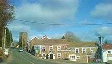
Llannon is a small village and community in the county of Carmarthenshire, Wales. It is located on the A476 road 11 miles south east of the county town, Carmarthen, between Tumble and Swiss Valley.
The community of Llannon, contains Llannon village, Tumble and Cross Hands.[1] The community is bordered by the communities of: Gorslas; Llandybie; Llanedi; Llangennech; Llanelli Rural; and Pontyberem, all being in Carmarthenshire.
History and amenities
Llannon has deep historical links with the Rebecca Riots and there is even rumoured to be a "secret passage" under the main road running through the village. This passage was said to have been used by Oliver Cromwell and possibly the Rebecca Rioters as an escape route. The passage runs from the Red Lion public house to the parish church.
Another public house, called the Greyhound Inn, lies on the Llannon to Hendy road junction. It is unknown which is older, but the road that the Greyhound Inn lies on has a watering fountain which was built to water horses of passing carts.
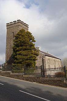
The parish church of St Non is a grade II* listed building.[2]
The village has a primary school and aside from the two pubs it lacks any other amenities such as a shop, which closed in the late 1990s. A refurbishment of the Greyhound Inn included the siting of a new village shop on the premises but this closed shortly after it opened.
Present day
The village has grown in recent years with two new small housing estates having been constructed since 1999. The area is now considered more of a commuter village due to its proximity to the M4 in Hendy. The local school recently underwent a large extension programme to cope with the increased demand for schooling from the growing population.
References
- ↑ Davies, John; Jenkins, Nigel (2008). The Welsh Academy Encyclopaedia of Wales. Cardiff: University of Wales Press. p. 503. ISBN 978-0-7083-1953-6.
- ↑ "Church of St Non, Llannon". British Listed Buildings. Retrieved 21 December 2013.
External links
Coordinates: 51°45′18″N 4°07′03″W / 51.7551°N 4.1175°W