List of stone circles in Dumfries and Galloway
This is a list of stone circles located in the Dumfries and Galloway council area. It is complied from Aubrey Burl's 'County Gazetteer of the Stone Circles in Britain, Ireland and Brittany'[1] and the Royal Commission on the Ancient and Historical Monuments of Scotland's 'Canmore' database.[2] Between them, these two sources list 61 stone circles in the region. It should be noted that many of these have been destroyed, some remains have not been conclusively identified as stone circles, some were dubious before their destruction and some have not been located by modern surveys.
The following sites are the best preserved:
- Cauldside Burn
- Claughreid
- Easthill
- Girdle Stanes
- Glenquicken
- Loupin Stanes
- Seven Brethren
- Standing Stones of Glenterrow
- Torhouskie
- Twelve Apostles
- Whitcastles
| Name | Image | Grid reference Coordinates |
Former county Parish |
Notes |
|---|---|---|---|---|
| Airdrie | NX 966 587 54°54′46″N 3°36′49″W / 54.912725°N 3.613694°W |
Kirkcudbrightshire
Kirkbean |
A stone circle was recorded in the Old Statistical Account for the parish in 1794 and thirty years later by George Chalmers, but by 1893 the circle could not be found nor was there any local knowledge of the site.[3]
| |
| Bagbie | NX 4979 5639 54°52′47″N 4°20′34″W / 54.879681°N 4.342786°W |
Kirkcudbrightshire
Kirkmabreck |
||
| Bombie | NX 7079 5018 54°49′47″N 4°00′47″W / 54.829781°N 4.01292°W |
Kirkcudbrightshire
Kirkcudbright |
| |
| Booth's Burn, Kirkslight Rig | NY 2221 8837 55°11′01″N 3°13′23″W / 55.183518°N 3.223108°W |
Dumfriesshire
Hutton and Corrie |
||
| Branteth | NY 28 75 55°04′08″N 3°07′16″W / 55.068796°N 3.121181°W |
Dumfriesshire
Kirkpatrick-Fleming |
| |
| Broathill | NY 26 69 55°00′53″N 3°09′03″W / 55.014598°N 3.150946°W |
Dumfriesshire
Kirkpatrick-Fleming |
| |
| Burntscarth Green Farm | NX 9898 8018 55°06′21″N 3°35′06″W / 55.105747°N 3.584863°W |
Dumfriesshire |
| |
| Carlin Stone | NX 3255 4971 54°48′51″N 4°36′26″W / 54.814238°N 4.60734°W |
Wigtownshire
Mochrum |
||
| Cauldside Burn | NX 5295 5711 54°53′14″N 4°17′38″W / 54.887086°N 4.293943°W |
Kirkcudbrightshire
Anwoth |
||
| Clachanmore | NX 083 467 54°46′44″N 4°58′54″W / 54.778958°N 4.981531°W |
Wigtownshire
Stoneykirk |
| |
| Claughreid | NX 5178 5600 54°52′36″N 4°18′42″W / 54.876774°N 4.311595°W |
Kirkcudbrightshire
Kirkmabreck |
||
| Claywarnies | NX 10 71 55°00′07″N 4°57′52″W / 55.00189°N 4.96443°W |
Wigtownshire
Inch |
| |
| Drumfern | NX 3999 7099 55°00′28″N 4°30′13″W / 55.007715°N 4.503519°W |
Kirkcudbrightshire
Minnigaff |
||
| Drummore | NX 6884 4597 54°47′29″N 4°02′29″W / 54.791465°N 4.041347°W |
Kirkcudbrightshire
Kirkcudbright |
||
| Easthill | NX 9193 7388 55°02′52″N 3°41′35″W / 55.047673°N 3.692922°W |
Kirkcudbrightshire
Lochrutton |
||
| Ernespie | NX 7747 6321 54°56′55″N 3°54′52″W / 54.948487°N 3.91454°W |
Kirkcudbrightshire
Kelton |
||
| Foregirth Farm | NX 95 83 55°08′05″N 3°38′26″W / 55.134801°N 3.640683°W |
Dumfriesshire |
| |
| Glaisters | NX 761 801 55°06′01″N 3°56′33″W / 55.100252°N 3.942559°W |
Kirkcudbrightshire
Kirkpatrick Durham |
| |
| Glenjorrie | NX 206 581 54°53′09″N 4°47′51″W / 54.885829°N 4.79761°W |
Wigtownshire
Old Luce |
| |
| Girdle Stanes |  |
NY 2535 9615 55°15′14″N 3°10′33″W / 55.253898°N 3.175867°W |
Dumfriesshire
Eskdalemuir |
|
| Glenquicken |  |
NX 5096 5821 54°53′51″N 4°19′44″W / 54.897385°N 4.328997°W |
Kirkcudbrightshire
Kirkmabreck |
|
| Glenquicken Moor 1 | NX 5079 5830 54°53′50″N 4°19′42″W / 54.897131°N 4.328202°W |
Kirkcudbrightshire
Kirkmabreck |
||
| Glenquicken Moor 2 | NX 5074 5833 54°53′51″N 4°19′44″W / 54.897385°N 4.328997°W |
Kirkcudbrightshire
Kirkmabreck |
| |
| Glenturk | NX 424 579 54°53′29″N 4°27′29″W / 54.891381°N 4.458009°W |
Wigtownshire
Wigtown |
| |
| Greystone Park | NX 9798 7690 55°04′34″N 3°35′58″W / 55.07608°N 3.599354°W |
Dumfriesshire
Dumfries |
||
| High Auchenlarie | NX 5395 5342 54°51′15″N 4°16′35″W / 54.854246°N 4.276497°W |
Kirkcudbrightshire | ||
| Holm of Daltallochan |  |
NX 5528 9422 55°13′16″N 4°16′35″W / 55.220978°N 4.276488°W |
Kirkcudbrightshire
Carsphairn |
|
| Kirkbean Parish | NX 97 59 54°55′11″N 3°36′03″W / 54.919637°N 3.600708°W |
Kirkcudbrightshire
Kirkbean |
| |
| Kirkgunzeon | NX 8657 6668 54°58′55″N 3°46′26″W / 54.981808°N 3.773912°W |
Kirkcudbrightshire
Kirkgunzeon |
||
| Kirkhill | NY 1396 9592 55°15′00″N 3°21′18″W / 55.249974°N 3.354933°W |
Dumfriesshire
Wamphray |
||
| Kirkmadrine | NX 0801 4848 54°47′40″N 4°59′16″W / 54.794401°N 4.987881°W |
Wigtownshire
Stoneykirk |
| |
| Knockshinnie | NX 6822 4517 54°47′03″N 4°03′02″W / 54.784118°N 4.05062°W |
Kirkcudbrightshire
Kirkcudbright |
||
| Laggangarn | NX 2223 7166 55°00′28″N 4°46′53″W / 55.007701°N 4.781301°W |
Wigtownshire | ||
| Little Balmae | NX 691 447 54°46′50″N 4°02′10″W / 54.780544°N 4.036054°W |
Kirkcudbrightshire
Kirkcudbright |
||
| Loch Mannoch 1 | NX 6628 6143 54°55′47″N 4°05′18″W / 54.929626°N 4.088299°W |
Kirkcudbrightshire
Tongland |
||
| Loch Mannoch 2 | NX 663 615 54°55′50″N 4°05′14″W / 54.930676°N 4.087339°W |
Kirkcudbrightshire
Tongland |
| |
| Lochmaben Stane |  |
NY 3123 6600 54°59′02″N 3°04′34″W / 54.983875°N 3.076073°W |
Dumfriesshire
Gretna |
|
| Longcastle | NX 3824 4810 54°48′06″N 4°31′05″W / 54.801653°N 4.517989°W |
Wigtownshire
Kirkinner |
||
| Loupin Stanes 1 | 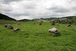 |
NY 2570 9663 55°15′30″N 3°10′14″W / 55.258263°N 3.170489°W |
Dumfriesshire
Eskdalemuir |
|
| Loupin Stanes 2 | NY 256 966 55°15′30″N 3°10′17″W / 55.258389°N 3.171358°W |
Dumfriesshire
Eskdalemuir |
| |
| Loupin Stanes 3 | NY 258 965 55°15′27″N 3°10′05″W / 55.257521°N 3.168186°W |
Dumfriesshire
Eskdalemuir |
| |
| Mains of Southwick | NX 93 57 54°54′03″N 3°39′44″W / 54.900834°N 3.662346°W |
Kirkcudbrightshire
Colvend and Southwick |
| |
| Miltonise | NX 1925 7405 55°01′41″N 4°49′46″W / 55.028078°N 4.829349°W |
Wigtownshire
New Luce |
||
| Morton Old Church | NX 8902 9696 55°15′16″N 3°44′51″W / 55.25433°N 3.747485°W |
Dumfriesshire
Morton |
| |
| Newlands | NX 96 85 55°09′11″N 3°37′33″W / 55.152976°N 3.625735°W |
Dumfriesshire |
| |
| Park, Tongland | 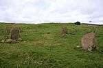 |
NX 6996 5609 54°52′58″N 4°01′43″W / 54.882642°N 4.028495°W |
Kirkcudbrightshire
Tongland |
|
| Queen Mary's Bridge | NX 7030 5476 54°52′15″N 4°01′21″W / 54.870786°N 4.022601°W |
Kirkcudbrightshire
Tongland |
| |
| Seven Brethren | NY 2171 8269 55°07′57″N 3°13′46″W / 55.132411°N 3.229387°W |
Dumfrieshire
Tundergarth |
||
| Shore Plantation | NX 6750 4636 54°47′41″N 4°03′44″W / 54.794615°N 4.062352°W |
Kirkcudbrightshire
Kirkcudbright |
| |
| Standing Stones of Balmennoch | NX 06 57 54°52′29″N 5°01′03″W / 54.874719°N 5.017445°W |
Wigtownshire
Inch |
||
| Standing Stones of Glenterrow |  |
NX 1453 6251 54°55′22″N 4°53′44″W / 54.922772°N 4.895622°W |
Wigtownshire
Inch |
|
| Steeps Park | NX 248 531 54°50′33″N 4°43′45″W / 54.842437°N 4.72918°W |
Wigtownshire
Old Luce |
||
| Stroan Loch | NX 640 709 55°00′52″N 4°07′40″W / 55.014467°N 4.127666°W |
Kirkcudbrightshire
Kells |
||
| Strongassel | NX 5923 8684 55°09′21″N 4°12′39″W / 55.155854°N 4.210771°W |
Kirkcudbrightshire
Kells |
||
| Templand Mains | NX 8771 9396 55°13′38″N 3°46′01″W / 55.227089°N 3.766889°W |
Dumfriesshire
Closeburn |
||
| The Thieves | NX 4044 7159 55°00′48″N 4°29′49″W / 55.013246°N 4.496825°W |
Kirkcudbrightshire
Minnigaff |
||
| Three Piked Stane | NY 2170 6787 54°59′57″N 3°13′32″W / 54.999266°N 3.225467°W |
Dumfriesshire
Annan |
||
| Torhouskie 1 |  |
NX 3825 5649 54°52′37″N 4°31′21″W / 54.876979°N 4.52253°W |
Wigtownshire
Wigtown |
|
| Torhouskie 2 | NX 3820 5644 54°52′35″N 4°31′24″W / 54.876514°N 4.52328°W |
Wigtownshire
Wigtown |
||
| Twelve Apostles |  |
NX 9470 7940 55°05′52″N 3°39′06″W / 55.09785°N 3.651629°W |
Dumfriesshire | |
| Wallace's Putting Stone | NX 7016 4381 54°46′21″N 4°01′12″W / 54.77241°N 4.019865°W |
Kirkcudbrightshire
Kirkcudbright |
| |
| Westerkirk Mains | NY 29 91 55°12′46″N 3°06′34″W / 55.212687°N 3.109507°W |
Dumfriesshire
Westerkirk |
||
| Whitcastles |  |
NY 2240 8806 55°10′51″N 3°13′12″W / 55.180763°N 3.220039°W |
Dumfriesshire
Hutton and Corrie |
|
| Windy Edge | NY 4304 8389 55°08′46″N 2°53′42″W / 55.146108°N 2.895135°W |
Dumfriesshire
Canonbie |
See also
References
- ↑ Burl, Aubrey (2000). "County Gazetteer of the Stone Circles in Britain, Ireland and Brittany". The stone circles of Britain, Ireland and Brittany. New Haven and London: Yale University Press. pp. 393–437. ISBN 0300083475.
- ↑ "Canmore Advanced Search: Stone Circle: Dumfries and Galloway". Retrieved 2014-12-31.
- 1 2 "Airdrie | Canmore". canmore.org.uk. Archived from the original on 2015-07-04. Retrieved 2015-05-30.
- ↑ "Bagbie | Canmore". canmore.org.uk. Archived from the original on 2015-07-04. Retrieved 2015-05-30.
- 1 2 3 4 5 Burl, Aubrey (2000). The stone circles of Britain, Ireland and Brittany. New Haven and London: Yale University Press. p. 429. ISBN 0300083475.
- ↑ "Bombie | Canmore". canmore.org.uk. Archived from the original on 2015-07-04. Retrieved 2015-07-04.
- ↑ "Booth's Burn, Kirkslight Rig | Canmore". canmore.org.uk. Archived from the original on 2015-07-04. Retrieved 2015-07-04.
- 1 2 3 4 5 6 7 8 9 10 11 12 13 14 Burl, Aubrey (2000). The stone circles of Britain, Ireland and Brittany. New Haven and London: Yale University Press. p. 426. ISBN 0300083475.
- ↑ "Branteth | Canmore". canmore.org.uk. Archived from the original on 2015-07-04. Retrieved 2015-07-04.
- ↑ "Broathill | Canmore". canmore.org.uk. Archived from the original on 2015-07-04. Retrieved 2015-07-04.
- ↑ "Burntscarth Green Farm | Canmore". canmore.org.uk. Archived from the original on 2015-07-04. Retrieved 2015-07-04.
- ↑ "Carlin Stone | Canmore". canmore.org.uk. Archived from the original on 2015-07-04. Retrieved 2015-07-04.
- 1 2 3 4 5 6 7 8 9 Burl, Aubrey (2000). The stone circles of Britain, Ireland and Brittany. New Haven and London: Yale University Press. p. 435. ISBN 0300083475.
- ↑ "Cauldside Burn | Canmore". canmore.org.uk. Archived from the original on 2015-07-04. Retrieved 2015-07-04.
- ↑ "Clachanmore | Canmore". canmore.org.uk. Retrieved 2015-07-04.
- ↑ "Claughreid | Canmore". canmore.org.uk. Retrieved 2015-07-04.
- ↑ "Claywarnies | Canmore". canmore.org.uk. Retrieved 2015-07-04.
- ↑ "Drumfern | Canmore". canmore.org.uk. Retrieved 2015-07-04.
- ↑ "Drummore | Canmore". canmore.org.uk. Retrieved 2015-07-04.
- ↑ "Easthill | Canmore". canmore.org.uk. Retrieved 2015-07-04.
- 1 2 3 4 5 6 7 8 9 10 11 12 13 14 Burl, Aubrey (2000). The stone circles of Britain, Ireland and Brittany. New Haven and London: Yale University Press. p. 430.
- ↑ "Ernespie | Canmore". canmore.org.uk. Retrieved 2015-07-04.
- ↑ "Foregirth Farm | Canmore". canmore.org.uk. Retrieved 2015-07-04.
- ↑ "Gaisters | Canmore". canmore.org.uk. Retrieved 2015-07-04.
- ↑ "Glenjorrie | Canmore". canmore.org.uk. Retrieved 2015-07-04.
- ↑ "Cote, 'girdle Stanes' | Canmore". canmore.org.uk. Retrieved 2015-07-04.
- ↑ "Glenquicken | Canmore". canmore.org.uk. Retrieved 2015-07-04.
- ↑ "Glenquicken Moor | Canmore". canmore.org.uk. Retrieved 2015-07-04.
- ↑ "Glenquicken Moor | Canmore". canmore.org.uk. Retrieved 2015-07-04.
- ↑ "Glenturk | Canmore". canmore.org.uk. Retrieved 2015-07-04.
- ↑ "Dumfries, Greystone Park | Canmore". canmore.org.uk. Retrieved 2015-07-04.
- ↑ "High Auchenlarie | Canmore". canmore.org.uk. Retrieved 2015-07-04.
- ↑ "Holm Of Daltallochan | Canmore". canmore.org.uk. Retrieved 2015-07-04.
- ↑ "Kirkbean Parish | Canmore". canmore.org.uk. Retrieved 2015-07-04.
- ↑ "Kirkgunzeon | Canmore". canmore.org.uk. Retrieved 2015-07-04.
- ↑ "Kirkhill | Canmore". canmore.org.uk. Retrieved 2015-07-04.
- ↑ "Kirkmadrine | Canmore". canmore.org.uk. Retrieved 2015-07-04.
- ↑ "Knockshinnie | Canmore". canmore.org.uk. Retrieved 2015-07-04.
- ↑ "Laggangarn | Canmore". canmore.org.uk. Retrieved 2015-07-04.
- ↑ "Little Balmae | Canmore". canmore.org.uk. Retrieved 2015-07-04.
- ↑ "Loch Mannoch | Canmore". canmore.org.uk. Retrieved 2015-07-04.
- ↑ "Loch Mannoch | Canmore". canmore.org.uk. Retrieved 2015-07-04.
- ↑ "Lochmaben Stone | Canmore". canmore.org.uk. Retrieved 2015-07-04.
- ↑ "Longcastle | Canmore". canmore.org.uk. Retrieved 2015-07-04.
- ↑ "'loupin Stanes', Hartmanor | Canmore". canmore.org.uk. Retrieved 2015-07-04.
- ↑ "Mains Of Southwick | Canmore". canmore.org.uk. Retrieved 2015-07-04.
- ↑ "Miltonise | Canmore". canmore.org.uk. Retrieved 2015-07-04.
- ↑ "Morton Old Church | Canmore". canmore.org.uk. Retrieved 2015-07-04.
- ↑ "Newlands | Canmore". canmore.org.uk. Retrieved 2015-07-04.
- ↑ "Park, Tongland | Canmore". canmore.org.uk. Retrieved 2015-07-04.
- ↑ "Queen Mary's Bridge | Canmore". canmore.org.uk. Retrieved 2015-07-04.
- ↑ "Seven Brethren | Canmore". canmore.org.uk. Retrieved 2015-07-04.
- ↑ "Shore Plantation | Canmore". canmore.org.uk. Retrieved 2015-07-04.
- ↑ "Standing Stones Of Balmennoch | Canmore". canmore.org.uk. Retrieved 2015-07-04.
- ↑ "Standing Stones Of Glenterrow | Canmore". canmore.org.uk. Retrieved 2015-07-04.
- ↑ "Steeps Park, High Gillespie | Canmore". canmore.org.uk. Retrieved 2015-07-04.
- ↑ "Stroan Loch | Canmore". canmore.org.uk. Retrieved 2015-07-04.
- ↑ "Stroangassel | Canmore". canmore.org.uk. Retrieved 2015-07-04.
- ↑ "Templand Mains | Canmore". canmore.org.uk. Retrieved 2015-07-04.
- ↑ "The Thieves | Canmore". canmore.org.uk. Retrieved 2015-07-04.
- ↑ "Three Piked Stane | Canmore". canmore.org.uk. Retrieved 2015-07-04.
- ↑ "Torhousekie | Canmore". canmore.org.uk. Retrieved 2015-07-04.
- ↑ "Torhousekie | Canmore". canmore.org.uk. Retrieved 2015-07-04.
- ↑ "The Twelve Apostles | Canmore". canmore.org.uk. Retrieved 2015-07-04.
- ↑ "Wallace's Putting Stone, Raeberry Hill | Canmore". canmore.org.uk. Retrieved 2015-07-04.
- ↑ "Westerkirk Mains | Canmore". canmore.org.uk. Retrieved 2015-07-04.
- ↑ "Whitcastles | Canmore". canmore.org.uk. Retrieved 2015-07-04.
- ↑ "Windy Edge | Canmore". canmore.org.uk. Retrieved 2015-07-04.