List of places of worship in Worthing
The borough of Worthing, one of seven local government districts in the English county of West Sussex, has 49 extant, operating churches and other places of worship. Sixteen other former places of worship are still in existence but are no longer in religious use. The district, on the south coast of England, is mostly urban:[3] it consists of the seaside resort of Worthing, established in the 19th century, and its residential suburbs, ranging from ancient villages absorbed by the growing town to housing estates built after World War II.[4]
Most residents identify themselves as Christian,[5] and there is only one non-Christian place of worship, a mosque. The Church of England, the country's officially established church, is represented by more churches than any other denomination, but Worthing's first church was an Independent chapel. Protestant Nonconformism flourished in the early 19th century during the town's early development, while Roman Catholic worship (after the Catholic Emancipation) took root somewhat later.
English Heritage has awarded listed status to 12 of Worthing's extant churches and two former church buildings. A building is defined as "listed" when it is placed on a statutory register of buildings of "special architectural or historic interest" in accordance with the Planning (Listed Buildings and Conservation Areas) Act 1990.[6] The Department for Culture, Media and Sport, a Government department, is responsible for this; English Heritage, a non-departmental public body, acts as an agency of the department to administer the process and advise the department on relevant issues.[7] There are three grades of listing status. Grade I, the highest, is defined as being of "exceptional interest"; Grade II* is used for "particularly important buildings of more than special interest"; and Grade II, the lowest, is used for buildings of "special interest".[8]
Overview of Worthing and its places of worship
The borough covers 8,030 acres (3,250 ha)[9] of the English Channel coast and its hinterland in West Sussex, a county in southeast England. It is bordered to the west and north by the district of Arun, to the east by the district of Adur, and to the south by the English Channel.[10]
The town of Worthing began as a development in the south of the parish of Broadwater, a manor of Saxon origin which at the time of the Domesday survey in 1086 was held by the Norman nobleman William de Braose, 1st Lord of Bramber.[11] What began as a modest fishing village[12] quickly grew into a popular residential area, helped by the concurrent development of fashionable Brighton further along the coast.[11] Worthing absorbed Broadwater and other ancient centres such as Goring,[13] Heene[14] and West Tarring[15] during the 19th century, and was incorporated as a borough in 1890.[4]
The old villages had their own Anglican churches; Worthing itself was served by St Mary's Church in Broadwater until a chapel of ease, St Paul's, was built in 1812.[1] It quickly became "the spiritual and social centre around which ... the town developed",[16] despite financial difficulties and complaints that it failed to serve Worthing's poor.[17] Several other Anglican churches were founded in the town centre during the 19th century, starting with Christ Church—which also started as a chapel of ease to St Mary's before it received its own parish.[18] Declining congregations have resulted in overcapacity, and Christ Church was threatened with closure in 2006.[19]
The first place of worship in Worthing, however, was an Independent chapel on the present Montague Street[20] (formerly Cross Lane).[21] Long since demolished and now the site of a shop, it was founded in 1804, and was rebuilt and re-established as a Congregational church in 1842 by Reverend L. Winchester, the founder of Congregationalism in the town.[20][22] Nonconformism thrived in the early town. Various Independent and Evangelical congregations became established; Wesleyan Methodism was first recorded in 1811, and Primitive Methodism in 1865; Baptist meetings were held from 1878, and a Strict Baptist chapel existed from 1907; Brethren registered their first place of worship in 1892, and subsequently occupied various buildings; and many other denominations have been—and in some cases still are—represented.[23] Roman Catholicism took until the middle of the 19th century to become established. The first permanent church, St Mary of the Angels, was opened in 1864; before that, Mass was celebrated in a local resident's private chapel and in the Sisters of Notre Dame de Sion's convent.[24] St Mary of the Angels was parished from 1918, and the ministry grew substantially under the leadership of Canon James Purdon, its priest for 53 years.[24][25] Other parishes were established in 1927 (Durrington; later moved to High Salvington), 1958 (East Worthing)[24] and 1970 (Goring-by-Sea). The latter church, dedicated to the English Martyrs, is of little architectural merit but has one remarkable feature: a two-thirds scale replica of the Sistine Chapel ceiling, hand-painted by an untrained artist in six years.[26][27][28] WORTHING is mentioned in Samuel Enderby II's 1797 will by a bequest to a rev. Mr. Jones minister Worthing Surrey; was this Surrey part of Sussex or another Worthing in 1797. The Will also makes bequests to other Presbyterians, notably to Hugh Worthington, Pastor of Salters Hall, London. The Jones bequest suggests that Worthing had Presbyterian Religion in the 18th. Century.
Mission halls
Worthing's Anglican churches established many mission halls—rudimentary chapels of ease administered by the founding church and serving newly developed residential areas—during the 19th and early 20th centuries. The town's haphazard, piecemeal, intermittently rapid residential development meant that such structures, which could be erected quickly, were needed to provide worship facilities until a more permanent arrangement could be made.[3][29][30] All fell out of use or were replaced by a permanent church, but some of the buildings still stand.
| Founding church | Mission hall | In use | Extant? | Status | Refs |
| Christ Church | Anglesea Street Mission | 1880–1930s | Yes | Now used as a Scout hut | [18][31] |
| Crescent Road Mission | 1900s–1920s | Yes | Now part of a shop | [31][32] | |
| St Andrew's Church | Victoria Road Mission | c. 1900 | No | Demolished | [31][32] |
| St Botolph's Church | St John's Mission Room | 1900 | No | Replaced by St John the Divine's Church | [14] |
| St George's Church | Emmanuel Mission | 1911–1976 | No | Replaced by permanent church, which was in turn demolished without replacement in 2008 | [31][32] [33] |
| Ham Arch Mission | 1885–1914 | Yes | Now used as a workshop | [31][32] | |
| Newland Road Mission | 1883–1936 | Yes | Became a hall, then a school; now a photographic studio | [31][32] | |
| St Mary's Church | Broadwater Mission Hall | 1903–c. 1993 | No | Replaced by Queen Street Church Centre | [18][34] |
| St Paul's Church | Church of the Good Shepherd | 1906–1963 | No | Demolished in 1973 | [31][32] |
Religious affiliation
According to the 2001 United Kingdom Census, 97,568 people lived in the borough of Worthing. Of these, 72.14% identified themselves as Christian, 0.75% were Muslim, 0.34% were Buddhist, 0.26% were Jewish, 0.22% were Hindu, 0.11% were Sikh, 0.46% followed a religion other than these, 16.99% claimed no religious affiliation and 8.73% did not state their religion.[5] The proportion of Christians was slightly higher than the 71.74% in England as a whole; Buddhism and other religions were also practised more widely in Worthing than nationally. Islam, Hinduism, Judaism and Sikhism had significantly fewer followers than average: in 2001, 3.1% of people in England were Muslim, 1.1% were Hindu, 0.7% were Sikh and 0.5% were Jewish. The proportion of people with no religious affiliation was higher than the national figure of 14.59%.[5]
Administration
All Anglican churches in the borough of Worthing are part of the Diocese of Chichester, whose cathedral is at Chichester in West Sussex.[35] The Rural Deanery of Worthing—one of five deaneries in the Archdeaconry of Chichester, which is in turn one of three archdeaconries in the diocese[36]—covers the borough in its entirety and includes some churches in neighbouring districts.[37]
The Roman Catholic Diocese of Arundel and Brighton, whose cathedral is at Arundel,[38] administers the four Roman Catholic churches in Worthing. Worthing Deanery, one of 13 deaneries in the diocese,[39] includes the parishes of Goring (Church of the English Martyrs), East Worthing (St Charles Borromeo Church, and a church in Lancing in the neighbouring district of Adur) and Worthing (St Mary of the Angels Church in central Worthing and St Michael's Church in High Salvington), as well as other parishes outside the borough.[40]
Open places of worship
| Name | Image | Location | Denomination/ Affiliation |
Grade | Notes | Refs |
|---|---|---|---|---|---|---|
| St Mary's Church | .jpg) |
Broadwater 50°49′40″N 0°22′24″W / 50.8278°N 0.3733°W |
Anglican | I | Broadwater's parish church has Saxon origins, but the present structure is late Norman. Nairn and Pevsner noted that the cruciform building, of flint with stone dressings, has impressive arches. The chancel was extensively remodelled in the 19th century. | [34][41] [42][43] [44][45] |
| St Mary's Church | .jpg) |
Goring-by-Sea 50°48′47″N 0°25′29″W / 50.8130°N 0.4246°W |
Anglican | II* | Decimus Burton rebuilt this late Norman church in the Gothic style in 1837. Hans Feibusch's mural representing Christ in Majesty, designed in 1954, is above the chancel arch. The exterior is rendered. | [43][46] [47][48] [49] |
| St Andrew's Church | 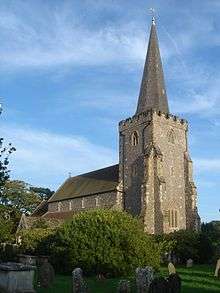 |
West Tarring 50°49′29″N 0°23′45″W / 50.8247°N 0.3958°W |
Anglican | II* | West Tarring's partly 13th-century parish church, in the Early English style, has Italian mosaic designs by William Butterfield in 1885, when a major restoration took place. Its longstanding ecclesiastical status as a peculier of Canterbury Cathedral may have influenced its design. | [15][32] [50][51] [52] |
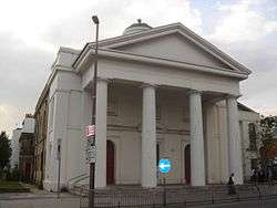
| Christ Church | 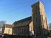 |
Worthing 50°48′48″N 0°22′25″W / 50.8132°N 0.3737°W |
Anglican | II* | Worthing's second Anglican church, built in 1840–1843 as a chapel of ease to Broadwater and parished in 1855, was reprieved from closure in 2006. The flint building also uses artificial stone—an early example of this. The chancel was altered in 1894, when a hammerbeam roof—likened to Bryant and May matchsticks by Harry Stuart Goodhart-Rendel—was added. | [19][31] [53][54] [55][56] [57][58] |
| St Symphorian's Church | .JPG) |
Durrington 50°50′11″N 0°24′48″W / 50.8364°N 0.4133°W |
Anglican | II | The ancient parish church was wrecked during the English Civil War, and remained disused until Lacy W. Ridge built a new structure incorporating its remains. It opened in 1916 and was extended (with a chancel) in 1941. | [1][59] [60][61] [62] |
| St George's Church | .jpg) |
East Worthing 50°48′51″N 0°21′26″W / 50.8142°N 0.3573°W |
Anglican | II | George Truefitt's Bargate stone, Decorated Gothic-style church was consecrated in 1868 and extended in 1875 and 1884. The chancel and adjacent aisle have large apses, and there is a bell-tower with a spirelet. The interior was refitted in 1990–91. | [31][43] [63][64] [65][66] [67] |
| St Botolph's Church |  |
Heene 50°48′49″N 0°23′12″W / 50.8136°N 0.3867°W |
Anglican | II | The ancient chapel at Heene, was ruined by the 18th century and partly dismantled in 1766. A fragment remains near the present church flint and stone church, built in the Early English style in 1873 by Edmund Scott and enlarged in 1905. | [14][43] [64][68] [69][70] |
| St John the Divine Church |  |
West Worthing 50°48′53″N 0°24′01″W / 50.8147°N 0.4004°W |
Anglican | II | In 1937, N.F. Cachemaille-Day built a brick and flint church to replace a mission chapel linked to St Botolph's. This building of 1900 was incorporated into the new structure, which was extended in 1965 when the short, broad tower and spire were added. | [43][64] [71][72] |
| Holy Trinity Church |  |
Worthing 50°48′41″N 0°22′43″W / 50.8113°N 0.3786°W |
Anglican | II | Late 19th-century housing development in the Gratwicke area west of the town centre resulted in the building of this church in 1882–1883. It was parished almost immediately. Henry Coe and S. Robinson's Early English design, in dark red brick, lacked the present tower; this was added in 1888. | [31][32] [55][67] [73] [74] |
| St Andrew's Church |  |
Worthing 50°48′55″N 0°22′39″W / 50.8153°N 0.3774°W |
Anglican | II | Worthing's first "High Church" Anglican church was so controversial that it stood unused for six years while liturgical differences were thrashed out. Arthur Blomfield's Early English church, eventually consecrated in 1888, uses flint and stonework extensively. | [31][64] [75][76] [77][78] |
| Queen Street Church Centre | 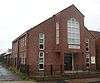 |
Broadwater 50°49′26″N 0°22′34″W / 50.8240°N 0.3760°W |
Anglican | – | This combined church and community centre was built in 1993–1994 on the site of the former Broadwater Mission Hall, administered from St Mary's Church. The present church is part of St Mary's parish. | [18][34] [79] |
| St Stephen's Church |  |
East Worthing 50°49′23″N 0°21′37″W / 50.8231°N 0.3604°W |
Anglican | – | Between 1929 and 1959, this was a mission chapel to St Mary's Church in Broadwater; but it was consecrated in 1959 and became a separate church in its own right. It remains within the parish of St Mary's. | [1][34] [79] |
| All Saints Church | .JPG) |
Findon Valley 50°51′01″N 0°23′45″W / 50.8504°N 0.3959°W |
Anglican | – | A church hall, erected in 1936, was used for services in this interwar housing estate until Keir Hett's brick church of 1956 was consecrated on 22 February of that year. The congregation chose the dedication. The church was parished in 1989, and St Peter's Church at High Salvington was added to the parish in 2010. | [18][80] [81] |
| St Laurence's Church | 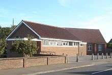 |
Goring-by-Sea 50°48′32″N 0°24′27″W / 50.8090°N 0.4074°W |
Anglican | – | Part of the parish of Goring-by-Sea, this church was founded in 1936. An attached hall was added in 1962. The interior has a 15th-century altarpiece retrieved from St Mary's Church, Slaugham. | [43][82] |
| St Peter's Church | .JPG) |
High Salvington 50°50′55″N 0°24′29″W / 50.8485°N 0.4081°W |
Anglican | – | The vicar of St Symphorian's Church paid for a tin tabernacle to be erected in High Salvington in 1928. It was part of St Symphorian's parish between 1951 and 2010—since when it has been linked to All Saints Church at Findon Valley—and is Worthing's only iron church. | [1][59] [64][81] [83] |
| St Richard's Church | 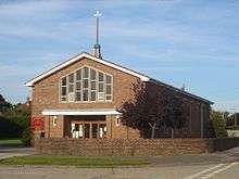 |
Maybridge 50°49′16″N 0°25′06″W / 50.8210°N 0.4183°W |
Anglican | – | This postwar housing estate north of Goring-by-Sea received a permanent church in 1966, when Romilly Craze's brick building opened. A church hall had accommodated services since 1954. A parish was created in 1980. | [1][64] |
| St Matthew's Church | 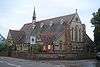 |
Worthing 50°49′04″N 0°22′59″W / 50.8179°N 0.3830°W |
Anglican | – | R.S. Hyde's Early English-style church has an apse and a narrow flèche, and uses locally quarried flint. It was built in 1899 and extended with vestries and aisles in 1911. | [1][31] [64][84] |
| Broadwater Baptist Church | 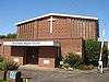 |
Broadwater 50°49′37″N 0°21′53″W / 50.8270°N 0.3648°W |
Baptist | – | R.W. Brough's 1968 brick structure is the successor to a church hall used since 1937 by Broadwater's Baptist community, which had first met in 1881 in a former stable. Another building on a different site was also used between 1904 and 1937. | [23][26] [61] |
| New Life Baptist Church | .JPG) |
Durrington 50°50′07″N 0°24′26″W / 50.8354°N 0.4073°W |
Baptist | – | This church acquired its name in 1985 but has its origins in a Free Church of 1912 which became Baptist in 1943. The present brick building, replacing the earlier structure, was completed in 1939. | [23][61] [85] |
| East Worthing Baptist Church | 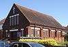 |
East Worthing 50°48′56″N 0°21′09″W / 50.8156°N 0.3525°W |
Baptist | – | In 1933, an Evangelical community founded a church in East Worthing; it was opened by Worthing's mayor the following year. The Baptist Church acquired the building, a brick structure designed by T.R. Hyde, in 1946. | [23][85] |
| Findon Valley Free Church | .JPG) |
Findon Valley 50°50′51″N 0°23′48″W / 50.8475°N 0.3966°W |
Baptist | – | The present octagonal-shaped building was designed by R.W. Brough in 1958, but this church has its origins in a church founded by Worthing Baptist Church in Findon in 1906, before the Findon Valley estate existed. It moved to a wooden building there in 1939. | [80][86] [87] |
| West Worthing Baptist Church |  |
West Tarring 50°49′12″N 0°23′33″W / 50.8199°N 0.3926°W |
Baptist | – | The present building is in three linked parts: Resta Moore's original church of 1900, which superseded a hall used by the Baptist community since 1890; Norman Myers's 1938 extension; and an adjacent community and social centre completed in 1988. | [61][85] [88] |
| Worthing Baptist Church | 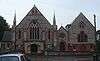 |
Worthing 50°48′57″N 0°22′31″W / 50.8159°N 0.3752°W |
Baptist | – | Worthing's first permanent Baptist place of worship opened on this site in 1881. Resta Moore built an extension of brick and flint four years later, and two more enlargements followed as the church's popularity grew. Its members helped to establish several Baptist churches within and outside Worthing. | [23][26] [61] |
| Worthing Tabernacle | .JPG) |
Worthing 50°48′53″N 0°22′16″W / 50.8148°N 0.3712°W |
Evangelical | II | James Lund's pale stone and dark brick building blends the Gothic and Romanesque Revival styles and has a distinctive rose window. It was built in 1908 to accommodate the Evangelical congregation who had previously worshipped at the Montague Street Tabernacle Chapel (built in 1839). | [23][43] [89][90] [91][92] [93] |
| Maybridge Community Church |  |
Maybridge 50°49′08″N 0°25′07″W / 50.8188°N 0.4186°W |
Evangelical | – | Founded in 1954 on the Maybridge housing estate, this Evangelical church is associated with the Worthing Tabernacle. The original structure, part of a former hospital, was rebuilt here; it has since been extended. As Maybridge Evangelical Free Church it was registered for marriages in February 1969. | [87][94] |
| West Worthing Evangelical Church | .JPG) |
West Worthing 50°48′58″N 0°23′55″W / 50.8162°N 0.3985°W |
Evangelical | – | James Lund, designer of the Worthing Tabernacle, adopted a different design—the Queen Anne style—for this church of 1912, built to serve an Evangelical community who had worshipped at a private house since 1900. | [23][87] [90] |
| River of Life Church |  |
Worthing 50°49′18″N 0°22′25″W / 50.8216°N 0.3735°W |
Evangelical | – | This Art Deco building was used by Christian Scientists between 1939 and 1987; it replaced a 1921 structure on the same site. After that congregation moved to West Worthing, the church was acquired by a congregation planted out of the New Life Church at Durrington. Under the name Oasis Centre, it was registered for marriages in May 1993, and it has also had the name Broadwater Christian Fellowship. | [23][90] [95][96][97] |
| Clifton Community Church | %2C_Worthing.jpg) |
Worthing 50°48′59″N 0°22′42″W / 50.8164°N 0.3782°W |
Evangelical | – | This Gothic-style stone and brick church has been used by several religious groups, including Baptists and Brethren, since it opened in 1905, and has undergone many changes of name. Its present status is Evangelical. | [23][89] [90] |
| Offington Park Methodist Church | 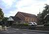 |
Broadwater 50°49′44″N 0°22′51″W / 50.8290°N 0.3808°W |
Methodist | – | The Wesleyan Methodist community acquired this site in 1928; the first church was opened in 1932, but it was replaced in 1958 with a new 400-capacity brick structure by architect G. Highet. Additions were made in the grounds in the 1970s. | [23][61] [98] |
| Goring Methodist Church |  |
Goring-by-Sea 50°48′49″N 0°25′48″W / 50.8135°N 0.4301°W |
Methodist | – | Methodist worship in Goring-by-Sea started in a local hall in 1945, and a permanent church was built six years later by John Leopold Denman. The long, low brick building has a small bronze spire. It was registered for marriages in April 1952. | [87][99] [100] |
| Cornerstone Methodist Church | 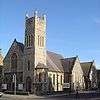 |
Worthing 50°48′42″N 0°21′59″W / 50.8118°N 0.3664°W |
Methodist | – | Architect John Wills was commissioned to build a replacement for the Bedford Row Methodist Chapel; his Early English style building, in rag-stone and featuring a corner tower, was completed in 1899 and opened in 1900. The church was reprieved from closure in 2003, at which time it was called Steyne Gardens Methodist Church, but it was announced in July 2015 that it would close at the end of August that year. | [20][23] [90][101] [102] |
| Tarring Road Methodist Church | 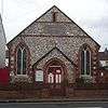 |
Worthing 50°49′04″N 0°22′46″W / 50.8179°N 0.3795°W |
Methodist | – | This Wesleyan chapel, completed in 1884, cost £735 (£69,000 as of 2016).[103] The brick and flint building was designed by R. Hollands. | [20][23] [90][103] |
| St Mary of the Angels Church |  |
Worthing 50°48′48″N 0°22′38″W / 50.8132°N 0.3773°W |
Roman Catholic | II | Henry Clutton's brick and Portland stone French Gothic-style church—Worthing's oldest public place of Roman Catholic worship—was opened in 1864 and completed in 1939 when Frederick Walters added a chancel. | [24][26] [28][64] [104][105] |
| St Charles Borromeo Church | 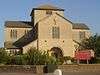 |
East Worthing 50°49′15″N 0°21′17″W / 50.8208°N 0.3546°W |
Roman Catholic | – | A dolphin sculpture above the door of this Neo-Romanesque, cruciform, artificial Cotswold stone church alludes to the earlier use of the Dolphin Inn for services. Henry Bingham Towner's building opened in 1962. | [24][26] [28][64] [106] |
| Church of the English Martyrs |  |
Goring-by-Sea 50°48′57″N 0°25′40″W / 50.8158°N 0.4277°W |
Roman Catholic | – | The concrete church opened in 1968 to replace a 1934 structure, now the church hall. Parishioner Gary Bevans painted a scale replica of the Sistine Chapel ceiling on the ceiling between 1988 and 1993. | [26][27] [28] |
| St Michael's Church | .JPG) |
High Salvington 50°50′31″N 0°24′18″W / 50.8419°N 0.4049°W |
Roman Catholic | – | This church moved to its present location in 1966 from Durrington, where the parish was formed in 1927 and a chapel was erected in 1938. The modernist design "departs from any conventionality" according to English Heritage. It was registered for marriages in October 1966. | [24][26] [28][64] [107] |
| Goring United Reformed Church |  |
Goring-by-Sea 50°48′58″N 0°24′37″W / 50.8162°N 0.4102°W |
United Reformed Church | – | World War II delayed the construction of this church for 11 years until 1949; a school was used for worship instead. The building became the church hall in 1961 when a new church, in brick and concrete and with exterior walls forming a series of V-shapes, opened. | [20][99] |
| Emmanuel United Reformed Church |  |
Heene 50°48′44″N 0°23′10″W / 50.8122°N 0.3860°W |
United Reformed Church | – | Founded in 1926 as St Columba's Presbyterian Church, the original church became the church hall in 1937 when it was replaced by an Art Deco structure with a tower and variegated brickwork. St Columba's and Shelley Road United Reformed Churches united in 2005 when the building in Shelley Road was closed. | [19][23] [61][108] |
| Christian Brethren Hall | .JPG) |
West Worthing 50°49′04″N 0°23′42″W / 50.8178°N 0.3951°W |
Brethren | – | This small hall, built in 1934 but given its present appearance by a 1950s remodelling, is the only extant Brethren place of worship in Worthing; three others are no longer used. | [23][85] |
| Worthing Christadelphian Church |  |
Worthing 50°49′00″N 0°22′42″W / 50.8167°N 0.3783°W |
Christadelphians | – | This community worships in a church used between 1961 and 1977 by Theosophists, who had a presence in Worthing from 1924. The structure was altered in 1989. It was registered for marriages by Christadelphians in September 1971. | [23][89] [109][110] |
| Kingdom Hall | West Worthing 50°49′03″N 0°23′43″W / 50.8175°N 0.3953°W |
Jehovah's Witnesses | – | This opened in 2015 on the site of the former Second Church of Christ, Scientist in Grand Avenue near West Worthing railway station. The purpose-built Kingdom Hall replaced a converted house on nearby South Street which had been the fifth Jehovah's Witnesses place of worship in Worthing since the denomination was established locally in 1922. The new building was registered for marriages in July 2015. | [23][95] [111] | |
| Church of Jesus Christ of Latter-day Saints, Worthing Chapel |  |
Goring-by-Sea 50°49′06″N 0°25′59″W / 50.8182°N 0.4330°W |
Latter-day Saint | – | The congregation, whose first meetings were held in 1964, numbered more than 300 by the 1980s, so a permanent church was built. The brick building opened in 1984 and was registered for marriages in August of that year. | [95][112] |
| Elim Church Worthing | 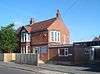 |
Worthing 50°49′15″N 0°22′21″W / 50.8208°N 0.3725°W |
Pentecostal | – | Since the Elim Tabernacle in Grosvenor Road closed in 1982, the Pentecostal community has used several venues, including this converted house on Broadwater Road. | [23][95] [113] |
| Friends Meeting House | 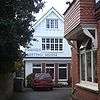 |
West Worthing 50°48′52″N 0°23′46″W / 50.8144°N 0.3962°W |
Quaker | – | Quakers first met in Worthing in the 1920s, and were peripatetic until 1945, when a private house was registered as a meeting house. In 1958 they built their own premises behind Mill Road. These have been shared with Spiritualists, Unitarians and others at various times. | [23][95] [89] |
| Salvation Army Citadel |  |
Worthing 50°48′37″N 0°22′36″W / 50.8104°N 0.3766°W |
Salvation Army | – | The Army has a controversial history in Worthing: their arrival in 1883 caused riots, led by a mob called the Skeleton Army. Peaceful relations had been established by the time a permanent citadel replaced temporary barracks accommodation in 1912. | [23][90] [114][115] |
| Worthing Spiritualist Church |  |
Worthing 50°48′46″N 0°22′26″W / 50.8128°N 0.3738°W |
Spiritualist | – | This Art Nouveau-influenced building, designed by a local architect, was opened for worship by Sir Arthur Conan Doyle in 1926, although it was built earlier. | [23][89] [90] |
| Masjid Assalam | 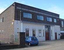 |
Worthing 50°49′09″N 0°22′12″W / 50.8193°N 0.3700°W |
Sunni Islam | – | Worthing's mosque doubles as a cultural and social centre for the local Muslim population. An early-morning arson attack in 2005 caused substantial damage, but the building has been repaired. The mosque had more than 1,000 worshippers in 2003. | [116][117] [118] |
Closed or disused places of worship
| Name | Image | Location | Denomination/ Affiliation |
Grade | Notes | Refs |
|---|---|---|---|---|---|---|
| St Paul's Church | |
Worthing 50°48′49″N 0°22′17″W / 50.8137°N 0.3714°W |
Anglican | II | An 1809 Act of Parliament allowed St Paul's to be built as a chapel of ease to St Mary's Church in Broadwater; it remained in force until 1893, when a parish was formed. It thrived as Worthing's reputation as a fashionable seaside resort grew, and the sale of pews to visitors brought in much money. John Rebecca's stuccoed brick building with Doric columns and cupola became structurally unsound and was closed in 1995. | [1][2] [31][64] [119][120] |
| Anglesea Street Mission | 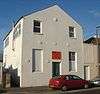 |
Worthing 50°49′01″N 0°22′44″W / 50.8169°N 0.3789°W |
Anglican | – | Christ Church's first mission hall was opened in the 1880s, originally under the name Clifton Road Mission Hall. Under its present name, Verrall Hall, it is a Scout headquarters. | [18][31] [121] |
| Crescent Road Mission | 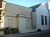 |
Worthing 50°48′37″N 0°22′34″W / 50.8102°N 0.3761°W |
Anglican | – | Originally a non-denominational mission chapel, this was taken over by Christ Church and used as a mission hall. It is now part of an adjacent shop. | [31][32] |
| Newland Road Mission | %2C_Worthing.jpg) |
Worthing 50°49′06″N 0°22′07″W / 50.8184°N 0.3686°W |
Anglican | – | Built in 1883 by St George's Church to serve new housing near the railway, this red-brick chapel, designed by George Hewer, was used until 1936. Under the new guise of Forester's Hall, it has been a school and a photographic studio. | [31][32] [122][123] |
| Ham Arch Mission | 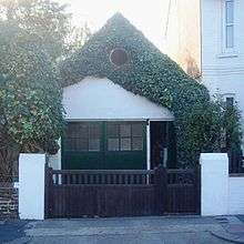 |
East Worthing 50°49′10″N 0°21′14″W / 50.8194°N 0.3538°W |
Anglican | – | Named after a nearby railway bridge, and ironically known as "The Cathedral" locally, this tiny hut—now a workshop—was served from St George's Church for 29 years from 1885. | [31][32] [124] |
| Brethren Gospel Hall |  |
West Tarring 50°49′31″N 0°23′35″W / 50.8253°N 0.3931°W |
Brethren | – | This tiny chapel, now in residential use, is set back from Tarring's ancient high street. It is in a simple Classical style with a pediment and oeil de boeuf. Services were held from 1860 until 1992. | [15][85] [90][125] |
| Christian Brethren Hall | 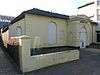 |
Worthing 50°48′37″N 0°22′08″W / 50.8103°N 0.3688°W |
Brethren | – | This stuccoed building of around 1850 was in religious use from 1910, by Brethren, Baptists and (from 1977) Evangelicals. It has fallen out of use and is unoccupied as of 2016. | [23][85] [90][126] |
| Gospel Hall | .JPG) |
Durrington 50°49′58″N 0°24′46″W / 50.8327°N 0.4127°W |
Brethren | – | Planning permission for this meeting hall on Birkdale Road was granted in 1990. It had a capacity for about 60 worshippers. In June 2011 the charity Scope stated that they had "recently" bought it and converted it into a social and activity centre. | [127][128] |
| Bedford Row Methodist Chapel | %2C_Worthing.JPG) |
Worthing 50°48′41″N 0°22′08″W / 50.8114°N 0.3690°W |
Methodist | II | Worthing's first Wesleyan Methodist chapel, the Providence Chapel of 1822, was replaced by this pedimented, stuccoed, Neoclassical building, with tall, tapering windows, in 1840. It passed into secular use in 1900 when the church in Steyne Gardens (now Cornerstone Methodist Church) replaced it, and is now the function room of the Vintners Parrot pub. | [23][61] [67][87] [129][130] |
| Lyndhurst Road Methodist Church | 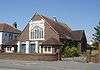 |
East Worthing 50°49′01″N 0°21′20″W / 50.8169°N 0.3556°W |
Methodist | – | An iron chapel for Primitive Methodists opened in Chapel Road in 1880, moved to Lyndhurst Road in 1893 and was superseded by H.K. Armitage's Perpendicular Gothic church in 1929. The Methodist Church declared it redundant in 2005, and permission was granted to establish a children's centre in it. | [23][61] [87][131] [132] |
| Methodist Providence Chapel | .JPG) |
Worthing 50°48′39″N 0°22′09″W / 50.8109°N 0.3691°W |
Methodist | – | This chapel was built in 1822 in a Neoclassical style using flint cobblestones on the exterior. After the new chapel in nearby Bedford Row was built in 1840, it was unused until 1852, when an independent Christian group took it on. The building now houses a youth club. | [20][23] [90] |
| Montague Street Tabernacle Chapel | 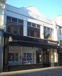 |
Worthing 50°48′37″N 0°22′15″W / 50.8104°N 0.3707°W |
Independent | – | This 1839 building had many uses (hall, theatre, temporary church) until 1895, when the Worthing Tabernacle was founded. It moved to its new premises in 1908, after which it was renamed St James's Hall and used as an entertainment venue. It is now a shop. | [23][89] [90] |
| New Street Chapel |  |
Worthing 50°48′36″N 0°22′32″W / 50.8101°N 0.3755°W |
Independent | – | This was built in the Classical style in 1861 for Independent Evangelicals. It declined after its founder, John Adams, died, and closed in 1906. The building survives behind a shop façade. | [23][85] [90] |
| Ebenezer Strict Baptist Chapel | .JPG) |
Worthing 50°48′46″N 0°22′22″W / 50.8129°N 0.3729°W |
Baptist | – | In 2005, planning permission was granted for the conversion of this Strict Baptist chapel into a house. The congregation formed in 1887 worshipped elsewhere until 1907, when the chapel was built. | [23][85] [90][133] |
| St James's Evangelical Free Church |  |
Worthing 50°48′45″N 0°22′03″W / 50.8124°N 0.3674°W |
Evangelical | – | T.H. Winney's Perpendicular-style building was used as an Evangelical church from 1926 until 1988, when it became a restaurant and bar. The name was derived from St James's Hall in Montague Street, where the congregation previously met. | [23][61] [87] |
| Kingdom Hall | 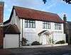 |
West Tarring 50°49′16″N 0°23′32″W / 50.8211°N 0.3922°W |
Jehovah's Witnesses | – | This converted house was the fifth Jehovah's Witnesses place of worship in Worthing. The denomination, which was first established in the town in 1922, moved to it in 1992. It was used by three Worthing-based Congregations of Jehovah's Witnesses: Broadwater, Durrington and Tarring. In 2013, a planning application was submitted to construct a purpose-built Kingdom Hall on the site of the disused Second Church of Christ, Scientist on nearby Grand Avenue. This was approved, building work was completed in 2015, and the old building's marriage registration was cancelled in July 2015. | [23][95] [134][135] [111] |
| Elim Tabernacle | 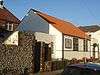 |
Worthing 50°48′49″N 0°22′25″W / 50.8135°N 0.3737°W |
Pentecostal | – | George Jeffreys, founder of the Elim Pentecostal Church in the United Kingdom, established this church in 1931. The small building, opposite Christ Church, was registered for worship in January 1935 and was used until 1982; a nursery school now occupies it. | [23][95] [136] |
| Shelley Road United Reformed Church | 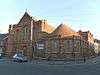 |
Worthing 50°48′40″N 0°22′29″W / 50.8112°N 0.3746°W |
United Reformed Church | – | This brick and terracotta Early English-style building served the Congregational (later United Reformed Church) community from 1904 until 2005, when the congregation moved to the renamed Emmanuel Church—formerly St Columba's. Its marriage registration was cancelled in January 2006. | [19][20] [23][61] [137][138] [139] |
See also
- Listed buildings in Worthing
- List of demolished places of worship in West Sussex
 Media related to Places of worship in Worthing at Wikimedia Commons
Notes
References
- 1 2 3 4 5 6 7 8 Elleray 1998, p. 50.
- 1 2 Nairn & Pevsner 1965, p. 386.
- 1 2 Salzman, L. F. (ed) (1980). "A History of the County of Sussex: Volume 6 Part 1 : Bramber Rape (Southern Part). Worthing: Growth of the town". Victoria County History of Sussex. British History Online. pp. 97–103. Retrieved 27 September 2009.
- 1 2 Elleray 1998, p. 96.
- 1 2 3 "Area: Worthing (Local Authority) – Religion (UV15)". "Neighbourhood Statistics" website. Office for National Statistics. 18 November 2004. Retrieved 25 September 2009.
- ↑ "Planning (Listed Buildings and Conservation Areas) Act 1990 (c. 9)". The UK Statute Law Database. Ministry of Justice. 24 May 1990. Retrieved 27 September 2009.
- ↑ "History of English Heritage". English Heritage. 2010. Retrieved 19 August 2011.
- ↑ "What does Listing mean?". English Heritage. 2008. Retrieved 27 September 2009.
- ↑ Elleray 1998, p. 36.
- ↑ "United Kingdom: Local Authority Districts, Counties and Unitary Authorities, March 2009" (PDF). Office for National Statistics. 2009. Retrieved 2 February 2012.
- 1 2 Elleray 1998, p. 42.
- ↑ Elleray 1998, p. 75.
- ↑ Elleray 1998, p. 72.
- 1 2 3 Salzman, L. F. (ed) (1980). "A History of the County of Sussex: Volume 6 Part 1 : Bramber Rape (Southern Part). Heene". Victoria County History of Sussex. British History Online. pp. 85–92. Retrieved 27 September 2009.
- 1 2 3 Salzman, L. F. (ed) (1980). "A History of the County of Sussex: Volume 6 Part 1 : Bramber Rape (Southern Part). West Tarring". Victoria County History of Sussex. British History Online. pp. 270–280. Retrieved 27 September 2009.
- ↑ Elleray 1999, Preface.
- ↑ Elleray 1999, p. 4.
- 1 2 3 4 5 6 Elleray 1998, p. 47.
- 1 2 3 4 "Historic church is facing closure". The Argus. Newsquest Media Group. 18 May 2006. Retrieved 27 September 2009.
- 1 2 3 4 5 6 7 Elleray 1998, p. 54.
- ↑ Elleray 1998, p. 121.
- ↑ Elleray 1998, p. 31.
- 1 2 3 4 5 6 7 8 9 10 11 12 13 14 15 16 17 18 19 20 21 22 23 24 25 26 27 28 29 30 31 Salzman, L. F. (ed) (1980). "A History of the County of Sussex: Volume 6 Part 1 : Bramber Rape (Southern Part). Worthing: Protestant nonconformity". Victoria County History of Sussex. British History Online. pp. 122–125. Retrieved 27 September 2009.
- 1 2 3 4 5 6 Salzman, L. F. (ed) (1980). "A History of the County of Sussex: Volume 6 Part 1: Bramber Rape (Southern Part). Worthing: Roman Catholicism". Victoria County History of Sussex. British History Online. p. 122. Retrieved 27 September 2009.
- ↑ Elleray 1998, p. 22.
- 1 2 3 4 5 6 7 Elleray 1998, p. 51.
- 1 2 Bridgewater 2007, pp. 52–54.
- 1 2 3 4 5 Sladen, Teresa; Antram, Nicholas (11 November 2005). "Architectural & Historic Review of Churches in the Roman Catholic Diocese of Arundel & Brighton" (PDF). Roman Catholic Diocese of Arundel and Brighton. Retrieved 22 September 2009.
- ↑ Elleray 1977, Introduction.
- ↑ Elleray 1985, Introduction.
- 1 2 3 4 5 6 7 8 9 10 11 12 13 14 15 16 17 Salzman, L. F. (ed) (1980). "A History of the County of Sussex: Volume 6 Part 1 : Bramber Rape (Southern Part). Worthing: Churches". Victoria County History of Sussex. British History Online. pp. 119–122. Retrieved 27 September 2009.
- 1 2 3 4 5 6 7 8 9 10 11 Elleray 1998, p. 48.
- ↑ "Worthing church facing the bulldozers". Chichester Observer. Johnston Press Digital Publishing. 25 April 2008. Retrieved 26 September 2011.
- 1 2 3 4 Salzman, L. F. (ed) (1980). "A History of the County of Sussex: Volume 6 Part 1 : Bramber Rape (Southern Part). Broadwater". Victoria County History of Sussex. British History Online. pp. 66–81. Retrieved 27 September 2009.
- ↑ "A little bit of history". Diocese of Chichester. 2012. Archived from the original on 19 January 2013. Retrieved 19 January 2013.
- ↑ "Deaneries in the Diocese of Chichester". Diocese of Chichester. 2009. Retrieved 27 September 2009.
- ↑ "Rural Deanery of Worthing". Diocese of Chichester. 2009. Retrieved 27 September 2009.
- ↑ "Arundel Cathedral Parish". Diocese of Arundel and Brighton website. DABNet. 2009. Retrieved 27 September 2009.
- ↑ "Deaneries of the Diocese". Diocese of Arundel and Brighton website. DABNet. 2009. Retrieved 27 September 2009.
- ↑ "Worthing Deanery". Diocese of Arundel and Brighton website. DABNet. 2009. Retrieved 27 September 2009.
- ↑ "Detailed Record: Broadwater Church (St Mary's), Broadwater Road (east side), Worthing, Worthing, West Sussex". Images of England. English Heritage. 2007. Retrieved 27 September 2009.
- ↑ Nairn & Pevsner 1965, pp. 390–392.
- 1 2 3 4 5 6 7 Elleray 1998, p. 49.
- ↑ Elleray 1985, §41.
- ↑ Elleray 1977, §§157, 158.
- ↑ "Detailed Record: St Mary's Church, Goring Road (north side), Worthing, Worthing, West Sussex". Images of England. English Heritage. 2007. Retrieved 27 September 2009.
- ↑ Elleray 2004, p. 25.
- ↑ Elleray 1977, §175.
- ↑ Nairn & Pevsner 1965, p. 231.
- ↑ "Detailed Record: West Tarring Church (St Andrew's), Church Road (south side), Worthing, Worthing, West Sussex". Images of England. English Heritage. 2007. Retrieved 27 September 2009.
- ↑ Elleray 1977, §168.
- ↑ Nairn & Pevsner 1965, pp. 392–393.
- ↑ Elleray 1998, pp. 47–48.
- ↑ "Detailed Record: Christ Church, Grafton Road (east side), Worthing, Worthing, West Sussex". Images of England. English Heritage. 2007. Retrieved 27 September 2009.
- 1 2 Elleray 2004, p. 56.
- ↑ Elleray 1977, §144.
- ↑ Nairn & Pevsner 1965, pp. 386–387.
- ↑ Elleray 1985, §42.
- 1 2 Salzman, L. F. (ed) (1980). "A History of the County of Sussex: Volume 6 Part 1 : Bramber Rape (Southern Part). Durrington". Victoria County History of Sussex. British History Online. pp. 81–85. Retrieved 28 September 2009.
- ↑ "Detailed Record: Durrington Church (St Symphorian's), Durrington Hill (west side), Worthing, Worthing, West Sussex". Images of England. English Heritage. 2007. Retrieved 28 September 2009.
- 1 2 3 4 5 6 7 8 9 10 11 Elleray 2004, p. 58.
- ↑ Elleray 1977, §172.
- ↑ "Detailed Record: St George's Church, St George's Road (east side), Worthing, Worthing, West Sussex". Images of England. English Heritage. 2007. Retrieved 28 September 2009.
- 1 2 3 4 5 6 7 8 9 10 11 Elleray 2004, p. 57.
- ↑ Elleray 1977, §147.
- ↑ Elleray 1985, §47.
- 1 2 3 Nairn & Pevsner 1965, p. 387.
- ↑ "Detailed Record: St Botolph's Church, Lansdowne Road (north side), Worthing, Worthing, West Sussex". Images of England. English Heritage. 2007. Retrieved 28 September 2009.
- ↑ Elleray 1977, §§148, 149.
- ↑ Elleray 1985, §52.
- ↑ Elleray 1985, §59.
- ↑ "Heritage Gateway Listed Buildings Online — Church of St John the Divine, Ripley Road, Worthing, West Sussex". Heritage Gateway website. Heritage Gateway (English Heritage, Institute of Historic Building Conservation and ALGAO:England). 2006. Retrieved 12 April 2011.
- ↑ Elleray 1977, §150.
- ↑ "Heritage Gateway Listed Buildings Online — Holy Trinity Church, Shelley Road, Worthing, West Sussex". Heritage Gateway website. Heritage Gateway (English Heritage, Institute of Historic Building Conservation and ALGAO:England). 2006. Retrieved 12 April 2011.
- ↑ Elleray 1998, pp. 48–49.
- ↑ "Detailed Record: St Andrew's Church, Victoria Road (east side), Worthing, Worthing, West Sussex". Images of England. English Heritage. 2007. Retrieved 28 September 2009.
- ↑ Elleray 1977, §151.
- ↑ Elleray 1985, §§54, 62.
- 1 2 "Broadwater". A Church Near You website. Archbishops' Council. 2009. Retrieved 30 September 2009.
- 1 2 Salzman, L. F. (ed) (1980). "A History of the County of Sussex: Volume 6 Part 1 : Bramber Rape (Southern Part). Findon". Victoria County History of Sussex. British History Online. pp. 20–34. Retrieved 28 September 2009.
- 1 2 "History". All Saints, Findon Valley, Worthing. 2013. Archived from the original on 22 May 2013. Retrieved 22 May 2013.
- ↑ "Goring-by-Sea, St Laurence". A Church Near You website. Archbishops' Council. 2009. Retrieved 30 September 2009.
- ↑ "Durrington". A Church Near You website. Archbishops' Council. 2009. Retrieved 30 September 2009.
- ↑ Elleray 1985, §56.
- 1 2 3 4 5 6 7 8 Elleray 1998, p. 52.
- ↑ Elleray 2004, p. 24.
- 1 2 3 4 5 6 7 Elleray 1998, p. 53.
- ↑ Elleray 1985, §60.
- 1 2 3 4 5 6 Elleray 1998, p. 56.
- 1 2 3 4 5 6 7 8 9 10 11 12 13 14 Elleray 2004, p. 59.
- ↑ "Detailed Record: The Worthing Tabernacle, 64 Chapel Road, Worthing, Worthing, West Sussex". Images of England. English Heritage. 2007. Retrieved 28 September 2009.
- ↑ Elleray 1985, §63.
- ↑ Elleray 1977, §156.
- ↑ The London Gazette: no. 44794. p. 2032. 21 February 1969. Retrieved 7 December 2012.
- 1 2 3 4 5 6 7 Elleray 1998, p. 55.
- ↑ The London Gazette: no. 53308. p. 8829. 20 May 1993. Retrieved 4 April 2012.
- ↑ "Our History". River of Life Church. 2013. Archived from the original on 22 May 2013. Retrieved 22 May 2013.
- ↑ Elleray 1998, pp. 53–54.
- 1 2 Elleray 2004, p. 26.
- ↑ The London Gazette: no. 39518. p. 2125. 8 April 1952. Retrieved 1 June 2012.
- ↑ Elleray 1985, §57.
- ↑ "Rescued Worthing church looks set to close for good". Worthing Herald. Johnston Publishing Ltd. 24 July 2015. Archived from the original on 30 July 2015. Retrieved 30 July 2015.
- 1 2 UK CPI inflation numbers based on data available from Gregory Clark (2016), "The Annual RPI and Average Earnings for Britain, 1209 to Present (New Series)" MeasuringWorth.
- ↑ "Detailed Record: St Mary's Roman Catholic Church, Richmond Road (south side), Worthing, Worthing, West Sussex". Images of England. English Heritage. 2007. Retrieved 28 September 2009.
- ↑ Elleray 1977, §146.
- ↑ Elleray 1985, §61.
- ↑ The London Gazette: no. 44161. p. 11909. 3 November 1966. Retrieved 10 December 2012.
- ↑ Elleray 1998, pp. 54–55.
- ↑ "Worthing". thisisyourbible.com. 2010. Retrieved 24 October 2010.
- ↑ The London Gazette: no. 45478. p. 10368. 24 September 1971. Retrieved 10 July 2012.
- 1 2 https://www.thegazette.co.uk/notice/2388562 (Temporary reference until issue and page numbers are obtained)
- ↑ The London Gazette: no. 49842. p. 11299. 17 August 1984. Retrieved 20 December 2012.
- ↑ "Elim Church Worthing: Contact us". Elim Church, Worthing. 2009. Retrieved 15 February 2010.
- ↑ Elleray 1998, pp. 124–125.
- ↑ Elleray 1985, §58.
- ↑ "Worthing Islamic Social and Welfare Society". Worthing Islamic Cultural Centre. 2008. Retrieved 28 September 2009.
- ↑ "Police probe broken gas pipe at Worthing mosque". Worthing Herald. Johnston Press Digital Publishing. 17 March 2005. Retrieved 28 September 2009.
- ↑ "Appeal to upgrade mosque". The Argus. Newsquest Media Group. 28 April 2003. Retrieved 28 September 2009.
- ↑ "Detailed Record: St Paul's Church, Chapel Road (west side), Worthing, Worthing, West Sussex". Images of England. English Heritage. 2007. Retrieved 28 September 2009.
- ↑ Elleray 1977, §§142, 143.
- ↑ "Worthing District Scouts". Worthing District Scouts. 2006–2008. Retrieved 28 September 2009.
- ↑ "Planning Application Property Related Information for: Foresters Hall 75 Newland Road Worthing West Sussex BN11 1LB". Worthing Borough Council planning application. Worthing Borough Council/CAPS Solutions Ltd. 2005. Retrieved 29 September 2009.
- ↑ "Worthing, St George: Centenary Brochure 1868–1968". Online copy of St George's Church Centenary brochure (published 1968) at www.achurchnearyou.com. Archbishops' Council. 2009. Retrieved 29 September 2009.
- ↑ Elleray 1985, §49.
- ↑ Elleray 1985, §43.
- ↑ Elleray 1985, §45.
- ↑ "Design and Access Statement" (PDF). Worthing Borough Council planning application AWDM/0294/11. Planning Services, Adur and Worthing Councils. 16 June 2011. Retrieved 2 November 2012.
Proposed single storey rear extension and alterations to front elevation including proposed porch. Deletion of condition 7 and 8 of planning permission WB/0273/90 relating to occupancy of the premises. Meeting Hall 1 Birkdale Road Worthing West Sussex BN13 2QY
- ↑ Registered in accordance with the Places of Worship Registration Act 1855 (Number in Worship Register: 82312; Name: Gospel Hall; Address: On the East Side of 5 Birkdale Road, Worthing; Denomination: Brethren). Retrieved 2 November 2012. (Archived version of list)
- ↑ Elleray 1977, §154.
- ↑ "Detailed Record: Bedford Hall, Bedford Row (west side), Worthing, Worthing, West Sussex". Images of England. English Heritage. 2007. Retrieved 10 October 2009.
- ↑ Robinson, Bryan; Back, Robert; White, Richard (June 2007). "Worthing: Lease of Lyndhurst Road Methodist Church for Conversion and use as Children's Centre" (PDF). Report FR30(06/07) by West Sussex County Council County Treasurer et al. West Sussex County Council. Retrieved 30 September 2009.
- ↑ The London Gazette: no. 33660. p. 7196. 11 November 1930. Retrieved 30 November 2012.
- ↑ "Planning Application: WB/05/1052/FULL". Worthing Borough Council planning application. Worthing Borough Council/CAPS Solutions Ltd. 2005. Retrieved 29 September 2009.
- ↑ "Congregation Meeting Search (State/Province: West Sussex)". jw.org (Jehovah's Witnesses) Congregation Finder app. Watch Tower Bible and Tract Society of Pennsylvania, Inc. 2012. Retrieved 29 November 2012. (Select "Search" then "Expand all details".)
- ↑ "Application for Planning Permission, Town and Country Planning Act 1990 (AWDM/0137/13)" (PDF). Adur & Worthing Councils. 4 February 2013. Archived from the original on 21 May 2013. Retrieved 21 May 2013.
Demolition of existing building and construction of a new single storey place of worship D1 with 26 parking spaces: Christian Science Church 117 Grand Avenue Worthing West Sussex BN11 5BE
- ↑ The London Gazette: no. 34123. p. 322. 11 January 1935. Retrieved 6 July 2012.
- ↑ Elleray 1985, §44.
- ↑ Elleray 1977, §152.
- ↑ The London Gazette: no. 57888. p. 1370. 31 January 2006. Retrieved 29 May 2013.
Bibliography
- Bridgewater, Peter (2007). An Eccentric Tour of Sussex. Alfriston: Snake River Press. ISBN 978-1-906022-03-7.
- Davies, Roger (1990). Tarring: a Walk Through its History. Tarring: Roger W. Davies. ISBN 0-9516309-0-3.
- Elleray, D. Robert (1977). Worthing: a Pictorial History. Chichester: Phillimore & Co. ISBN 0-85033-263-X.
- Elleray, D. Robert (1985). Worthing: Aspects of Change. Chichester: Phillimore & Co. ISBN 0-85033-551-5.
- Elleray, D. Robert (1998). A Millennium Encyclopaedia of Worthing History. Worthing: Optimus Books. ISBN 0-9533132-0-4.
- Elleray, D. Robert (1999). St Paul's Church, Worthing: a History and Description. Worthing: Optimus Books. ISBN 0-9533132-1-2.
- Elleray, D. Robert (2004). Sussex Places of Worship. Worthing: Optimus Books. ISBN 0-9533132-7-1.
- Evans, Nat (1977). The Church and Parish of Durrington. Worthing: Gadd's.
- Hare, Chris (1991). Historic Worthing: The Untold Story. Adlestrop: The Windrush Press. ISBN 0-900075-91-0.
- Kerridge, Ronald; Standing, Michael (2000). Worthing: From Saxon Settlement to Seaside Town. Worthing: Optimus Books. ISBN 0-9533132-4-7.
- Nairn, Ian; Pevsner, Nikolaus (1965). The Buildings of England: Sussex. Harmondsworth: Penguin Books. ISBN 0-14-071028-0.
- Pé, Diana (2006). Mid Sussex Church Walks. PP (Pé Publishing). ISBN 0-9543690-2-5.
- Vigar, John E. (1986). Exploring Sussex Churches. Rainham: Meresborough Books. ISBN 0-948193-09-3.
- No. 11: Worthing. West Sussex Local History Mini-Guide to Sources. Chichester: West Sussex County Council. 2000. ISBN 0-86260-465-6.
Places of worship in Sussex (by district) | ||
|---|---|---|
| East Sussex | .jpg) | |
| West Sussex | ||
| Demolished | ||
| Cathedrals | ||