List of national parks of Norway


Norway has 44 national parks, of which 37 are on the mainland and 7 on Svalbard. National parks in Norway are stricter than many other countries, and nearly all motorized vehicles are prohibited. The freedom to roam applies, thus hiking, skiing and camping throughout the park are permitted, given that consideration to nature is taken. Roads, accommodation and national park centers are located outside the national parks. The parks are under the management of the Norwegian Directorate for Nature Management and the local county governor.[1]
Ytre Hvaler is a marine park and all parks in Svalbard also contain marine areas. Sør-Spitsbergen is the largest park, covering an area of 13,286 km2 (5,130 sq mi), although only 5,141 km2 (1,985 sq mi) is land.[2] The largest park on the mainland is Hardangervidda, which covers an area of 3,422 km2 (1,321 sq mi). Gutulia is the smallest, covering 23 km2 (8.9 sq mi).[1]
Geography and history
At least 60% of Norway's area is mountainous, lakes or bogs (non-arable land, some of it is used as pastures); 37% is forest of various kinds; and only 3% arable land. It is estimated that between 1900 and 2003 areas more than 5 km from intense construction activity has decreased from 48% to 12% in Norway.
Until about one hundred years ago there was relatively little threat to ecosystems in Norway. The first initiatives to protect land were voiced in 1904, by Yngvar Nielsen, leader of the Norwegian Mountain Touring Association (DNT). The association continued to lobby cases in 1923 and 1938. The natural protection act of 1954 prepared a legal basis for establishing protection areas, and the two first national parks were established in 1962 and 1963. The act of 1954 also established Statens naturvernråd ("Governmental Natural protection council") as an advisory body for the government. The council presented a draft for further natural protecting in 1964, suggesting 16 national parks. These suggestions were approved by Stortinget. It took 25 years, until 1989, before 15 of their suggestions were fulfilled. The 16th suggestion became a naturreservat. The council presented another suggestion in 1986,[3] and this was approved by Stortinget in April 1993. Following this approval, a "second generation" of national parks, as well as expanding borders for the elder, were established from 2001.
The post-industrial era that started in the last 1960s saw areas being protected as national parks or other protected status as a means to regulate the construction of vacation homes, roads, fishing, hunting, and gathering plants. This trend has accelerated in the last 10 years. In addition to preserving rare plant and animal life, areas are protected to maintain reference points for environmental research, recreational resources for Norwegians, and as an inheritance for future generations. The Directorate for Nature Management maintains indicators for the health of nature in Norway, including such measures as biological diversity, erosion, signs of pollution.
For the most part, national parks are open to hiking, cross-country skiing and camping. Most have a limited number of overnight cabins.
In addition to national parks, the Norwegian government has designated larger areas for protection. Included in these areas are 153 landscapes covering 14071 km2; 1,701 nature reserves covering 3,418 km2; 24 national parks covering 21,650 km2; 102 natural memorials, and 98 smaller protected areas. This accounts for 12.1% of Norway's mainland area.
The Norwegian government aims to increase this area over time to at least 15%. They have signalled an interest in preserving marine ecosystems, including the fjords of the western parts of Norway, and the archipelago southwest from Oslo.
Current
| Image | Name | County(s) | Est. | Area | Description | Ref |
|---|---|---|---|---|---|---|
 |
Ånderdalen | Troms | 1970 | 125 km2 (48 sq mi) | [1] | |
| — | Blåfjella–Skjækerfjella | Nord-Trøndelag | 2004 | 1,924 km2 (743 sq mi) | [1] | |
 |
Breheimen | Oppland, Sogn og Fjordane | 2009 | 1,671 km2 (645 sq mi) | ||
 |
Børgefjell | Nord-Trøndelag, Nordland | 1963 | 1,447 km2 (559 sq mi) | [1] | |
| |
Dovre | Oppland | 2003 | 289 km2 (112 sq mi) | [1] | |
 |
Dovrefjell–Sunndalsfjella | Møre og Romsdal, Oppland, Sør-Trøndelag | 1974 | 1,693 km2 (654 sq mi) | [1] | |
 |
Færder | Vestfold | 2013 | 350 km2 (140 sq mi) | [1] | |
 |
Femundsmarka | Hedmark, Sør-Trøndelag | 1971 | 573 km2 (221 sq mi) | [1] | |
 |
Folgefonna | Hordaland | 2005 | 545 km2 (210 sq mi) | [1] | |
.jpg) |
Forlandet | Svalbard | 1973 | 4,647 km2 (1,794 sq mi) | The park covers the uninhabited island of Prins Karls Forland and the surrounding waters. Forlandet is long and narrow with tall peaks, separated in two by the low Forlandsletta. It is the northern-most habitat of harbor seal and a nesting place for common guillemot. Wetland birds nest at Plankeholmane and Forlandsøyane, and the west coast is an overwintering site for seabirds. | [2] |
 |
Forollhogna | Sør-Trøndelag, Hedmark | 2001 | 1,062 km2 (410 sq mi) | [1] | |
 |
Fulufjellet | Hedmark | 2012 | 83 km2 (32 sq mi) | [4] | |
 |
Gutulia | Hedmark | 1968 | 23 km2 (8.9 sq mi) | [1] | |
 |
Hallingskarvet | Buskerud, Hordaland | 2006 | 450 km2 (170 sq mi) | ||
 |
Hardangervidda | Buskerud, Hordaland, Telemark | 1981 | 3,422 km2 (1,321 sq mi) | [1] | |
 |
Indre Wijdefjorden | Svalbard | 2005 | 1,127 km2 (435 sq mi) | Located in a steep fjord landscape in northern Spitsbergen, the park covers the inner part of Wijdefjorden—the longest fjord on Svalbard. On both sides of Wijdefjorden there is High Arctic steppe vegetation, dominated by grasses and extremely dry, basic earth. Along with vegetation found on nesting cliffs, it is the most exclusive flora in Svalbard. Of the larger fjords on Svalbard, Wijdefjorden is the least affected by humans. | [2] |
 |
Jostedalsbreen | Sogn og Fjordane | 1991 | 1,310 km2 (510 sq mi) | [1] | |
 |
Jotunheimen | Oppland, Sogn og Fjordane | 1980 | 1,151 km2 (444 sq mi) | [1] | |
 |
Junkerdal | Nordland | 2004 | 682 km2 (263 sq mi) | [1] | |
 |
Làhku | Nordland | 2012 | 188 km2 (73 sq mi) | ||
 |
Langsua | Oppland | 2011 | 537 km2 (207 sq mi) | ||
| — | Lierne | Nordland | 2004 | 333 km2 (129 sq mi) | [1] | |
 |
Lomsdal–Visten | Nordland | 2009 | 682 km2 (263 sq mi) | ||
 |
Møysalen | Nordland | 2003 | 51 km2 (20 sq mi) | ||
.jpg) |
Nordenskiöld Land | Svalbard | 2003 | 1,362 km2 (526 sq mi) | The park covers the southern part of Nordenskiöld Land, on the north shore of Van Mijenfjorden. Reindalen is Svalbard's largest ice-free valley and features moraines, rock glaciers, pingos and avalanche features. The valley has a luch vegetation and the lower part is a wetland. The area is important for reindeer, Arctic fox, waders, geese and ducks. | [2] |
 |
Nordre Isfjorden | Svalbard | 2003 | 2,954 km2 (1,141 sq mi) | Protecting the northern shore of Isfjorden on Spitsbergen, the park consists of a long shore-line with lush vegetation serving as breeding grounds for birds. The landscape varies from the barren and lunar-like to sandy plains and several meter-thick layers of deposits. | [2] |
 |
Nordvest-Spitsbergen | Svalbard | 1973 | 9,914 km2 (3,828 sq mi) | The northwestern part of Spitsbergen has the archipelago's most varied nature and features some of the most important cultural heritage sites from whaling and Arctic exploration, such as Smeerenburg and Virgohamna. The park is habitat for Arctic fox, reindeer and Arctic char. Moffen Nature Reserve and three bird sanctuaries (Guissezholmen, Moseøya and Skorpa) are important breeding grounds for birds, especially eider and geese. The warm springs of Bockfjorden give a unique local flora. | [2] |
 |
Øvre Anárjohka | Finnmark | 1975 | 1,390 km2 (540 sq mi) | [1] | |
 |
Øvre Dividal | Troms | 1971 | 750 km2 (290 sq mi) | [1] | |
 |
Øvre Pasvik | Finnmark | 1970 | 119 km2 (46 sq mi) | Part of Pasvik–Inari Trilateral Park, the area is dominated by Siberian-like taiga consisting of old-growth Scots pine, shallow lakes and bog. The traditional Skolts area is still used for reindeer husbandry. The park located in Pasvikdalen and is a habitat for brown bear and moose. | [5] |
 |
Rago | Nordland | 1971 | 171 km2 (66 sq mi) | [1] | |
 |
Reinheimen | Oppland, Møre og Romsdal | 2006 | 1,969 km2 (760 sq mi) | ||
 |
Reisa | Troms | 1986 | 803 km2 (310 sq mi) | [1] | |
 |
Rohkunborri | Troms | 2011 | 571 km2 (220 sq mi) | ||
 |
Rondane | Hedmark, Oppland | 1962 | 963 km2 (372 sq mi) | [1] | |
 |
Saltfjellet–Svartisen | Nordland | 1989 | 2,102 km2 (812 sq mi) | [1] | |
 |
Sassen–Bünsow Land | Svalbard | 2003 | 1,230 km2 (470 sq mi) | The park covers Tempelfjorden, Bünsow Land and the vast fluvial plain of Sassendalen, located at the head of Isfjorden. Tempelfjorden is an important breeding ground for ringed seals, while Sassendalen and Gipsdalen are important breeding grounds for geese. Bünsow Land has the only European occurrence of polar mouse-ear and broad-sepal saxifrage. | [2] |
 |
Seiland | Finnmark | 2006 | 316 km2 (122 sq mi) | ||
 |
Sjunkhatten | Nordland | 2010 | 417 km2 (161 sq mi) | ||
 |
Skarvan and Roltdalen | Nord-Trøndelag, Sør-Trøndelag | 2004 | 441 km2 (170 sq mi) | [1] | |
_2.jpg) |
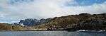
Sør-Spitsbergen | Svalbard | 1973 | 13,286 km2 (5,130 sq mi) | Covering the southern part of Spitsbergen (Wedel Jarlsberg Land, Torell Land and Sørkapp Land), the western part has jagged mountains while the eastern part is more rounded. Hornsund is an important migration area for polar bears, while four bird sanctuaries (Olsholmen, Isøyane, Dunøyane and Sørkapp) are vital nesting grounds for migratory seabirds. | [2] |
 |
Stabbursdalen | Finnmark | 1970 | 747 km2 (288 sq mi) | [1] | |
 |
Varangerhalvøya | Finnmark | 2006 | 1,804 km2 (697 sq mi) | ||
 |
Ytre Hvaler | Østfold | 2009 | 354 km2 (137 sq mi) |
Former
| Name | County | Established | Disestablished | Area (land, km2) |
Area (land, sq mi) |
Replaced by | Ref |
|---|---|---|---|---|---|---|---|
| Gressåmoen | Nord-Trøndelag | 1970 | 2004 | 182 | 70 | Blåfjella–Skjækerfjella | |
| Ormtjernkampen | Oppland | 1968 | 2011 | 9 | 3 | Langsua | [1] |
Planned
| National park | County | Size km2 | Outdoor recreational facilities provided |
|---|---|---|---|
| Dåapma [6] | Nord-Trøndelag | 261 | |
| Lofotodden [7] | Nordland | ~100 | |
| Muvrrešáhpi [8] | Finnmark | 291 | No |
| Preikestolen [9] | Rogaland | 215 | Marked trails |
| Saltfjellet–Svartisen (extension)[10] | Nordland | Additional 120 | Marked trails |
| Treriksrøysa[11] | Troms | ? | Unmarked trails and a hut. |
| Tysfjord–Hellemobotn [12] | Nordland | ~1000 | Boat to Hellemobotn |
| Ånderdalen (extension) [13] | Troms | 9.4 | |
| Øvre Anarjohka (extension)[14] | Finnmark | additional 624.6 | A gravel road. |
There are also several national park proposals: Solværøyene, Storheia;[15] Raet;[16] Jomfruland;[17] Melkevatn–Hjertvatn–Børsvatn, Okstindan;[18] Frafjordheiene;[19] Oksøy-Ryvingen;[20] Setesdal Vesthei, Trollheimen, Lyngsalpan.;[21] Østmarka.[22]
References
- 1 2 3 4 5 6 7 8 9 10 11 12 13 14 15 16 17 18 19 20 21 22 23 24 25 26 "Maps and information" (PDF). Norwegian Directorate for Nature Management. Retrieved 21 August 2011.
- 1 2 3 4 5 6 7 8 "Protected Areas in Svalbard". Norwegian Directorate for Nature Management. Retrieved 14 May 2010.
- ↑ Ny landsplan for nasjonalparker / fra en arbeidsgruppe oppnevnt 3. September 1982 ; utredningen avgitt til Miljøverndepartementet April 1986. Oslo, 1986 (Norges offentlige utredninger ; NOU 1986: 13). ISBN 82-00-71038-6
- ↑ "Fulufjellet nasjonalpark er oppretta" (Norwegian). Miljøverndepartementet. Retrieved 22 May 2012.
- ↑ "Øvre Pasvik nasjonalpark" (PDF) (in Norwegian). Norwegian Directorate for Nature Management. Archived from the original on 24 August 2012. Retrieved 24 August 2012.
- ↑ "Utredning Dåapma nasjonalpark" (Norwegian). Fylkesmannen i Nord-Trøndelag. Retrieved 13 June 2011.
- ↑ "Lofotodden nasjonalpark. Forstudium til konsekvensanalyse" (Norwegian). Moskenes Kommune. Retrieved 14 March 2012.
- ↑ "DN tilrår nasjonalpark og landskapsvernområde i Goahteluoppal" (Norwegian). Fylkesmannen i Finnmark. Retrieved 7 January 2011.
- ↑ "Preikestolen nasjonalpark" (Norwegian). Fylkesmannen i Rogaland. Retrieved 13 June 2011.
- ↑ "Informasjon om utvidelse av Saltfjellet-Svartisen nasjonalpark" (Norwegian). Fylkesmannen i Troms. Retrieved 18 June 2009.
- ↑ "Knapt med tid for Treriksrøysa" (Norwegian). lokalavisa.no. 01/09 2008. Retrieved 18 June 2009. Check date values in:
|date=(help) - ↑ "Milepæl for sikring av samiske- og miljøinteresser" (Norwegian). Fylkesmannen i Nordland. Retrieved 18 June 2009.
- ↑ "Miljødirektoratets tilrådning om utvidelse av Ånderdalen nasjonalpark" (Norwegian). Miljødirektoratet. Retrieved 10 April 2014.
- ↑ "Verneplan - mulig utvidelse av Øvre Anárjohka nasjonalpark" (Norwegian). Fylkesmannen i Finnmark. Retrieved 18 September 2009.
- ↑ "Vindmølle- eller kystnasjonalpark?" (Norwegian). Naturvernforbundet. Retrieved 30 May 2012.
- ↑ "Raet blir nasjonalpark!" (Norwegian). Fylkesmanne i Aust-Agder. Retrieved 30 January 2013.
- ↑ "Jomfruland Nasjonalpark?" (Norwegian). Fylkesmanne i Telemark. Retrieved 30 May 2012.
- ↑ "VERNEPLAN FOR SKOG PÅ STATSKOG OG OPPLYSNIGSVESENETS FONDS GRUNN" (Norwegian). DIREKTORATET FOR NATURFORVALTNING. Retrieved 30 May 2012.
- ↑ "Frafjordheiene: nasjonalpark i Rogaland" (Norwegian). Stavanger turistforening and Kjell Helle Olsen. Retrieved 23 July 2012.
- ↑ "Skrinla nasjonalpark-utredning" (Norwegian). Agder Flekkefjords Tidende. Retrieved 8 May 2014.
- ↑ "Nasjonalparkplanen ++" (Norwegian). Dirnat. Retrieved 27 November 2012.
- ↑ "Drøfter nasjonalpark i Østmarka" (Norwegian). dittOslo. Retrieved 4 February 2013.
External links
| Wikimedia Commons has media related to National parks of Norway. |
- National Park Visitor Centers
- Directorate for Nature Management
- Pictures of all mainland national parks
