List of lighthouses in Washington
This is a list of all lighthouses in the U.S. state of Washington as identified by the United States Coast Guard.[1] There are eighteen active lights in the state; three are standing but inactive, three were supplanted by automated towers, and two have been completely demolished. Two lights, one of them still active, serve as museums.
The Cape Disappointment Light was the first lighthouse in the state (lit 1856) and is still active.[2]
If not otherwise noted, focal height and coordinates are taken from the United States Coast Guard Light List,[3] while location and dates of activation, automation, and deactivation are taken from the United States Coast Guard Historical information site for lighthouses.[1]
| Name | Location | Coordinates | Image | Focal
Height | Built[note 1] | Automated | Deactivated | Status |
|---|
| Admiralty Head Light | Coupeville, Washington | 48°09′39″N 122°40′52″W / 48.1608°N 122.6810°W / 48.1608; -122.6810 (Admiralty Head Light)[4] | 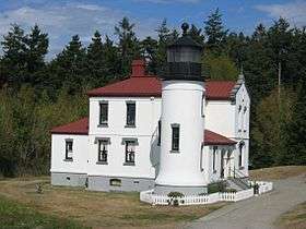 | 120 120 ft (37 m) | 1860/1903 | | 1922 | Inactive/museum |
| Alki Point Light | Alki Point, Seattle | 47°34′35″N 122°25′14″W / 47.5763°N 122.4206°W / 47.5763; -122.4206 (Alki Point Light) | 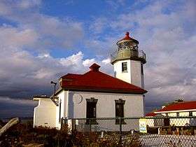 | 039 39 ft (12 m) | 1887/1913 | 1984 | | Active |
| Browns Point Light | Browns Point, Washington | 47°18′21″N 122°26′39″W / 47.3059°N 122.4443°W / 47.3059; -122.4443 (Browns Point Light) | 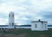 | 038 38 ft (12 m) | 1887/1933 | 1963 | | Active |
| Burrows Island Light | Burrows Island in Rosario Strait | 48°28′40″N 122°42′49″W / 48.4779°N 122.7135°W / 48.4779; -122.7135 (Burrows Island Light) |  | 057 57 ft (17 m) | 1906 | 1972 | | Active |
| Cape Disappointment Light | Cape Disappointment | 46°16′33″N 124°03′08″W / 46.2758°N 124.0522°W / 46.2758; -124.0522 (Cape Disappointment Light) |  | 220 220 ft (67 m) | 1856 | 1962 | | Active |
| Cape Flattery Light | Tatoosh Island | 48°23′31″N 124°44′13″W / 48.3919°N 124.7370°W / 48.3919; -124.7370 (Cape Flattery Light) | 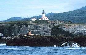 | 165 165 ft (50 m) | 1857 | 1977 | 2009[2] | Inactive[note 2] |
| Cattle Point Light | San Juan Island[5] | 48°27′02″N 122°57′48″W / 48.4506°N 122.9633°W / 48.4506; -122.9633 (Cattle Point Light) |  | 095 94 ft (29 m) | 1888/1935[5] | | | Active |
| Destruction Island Light | Destruction Island | 47°40′28″N 124°29′13″W / 47.6745°N 124.4869°W / 47.6745; -124.4869 (Destruction Island Light)[6] |  | 165 165 ft (50 m)[7] | 1891 | 1968 | 2008[6] | Inactive |
| Dofflemyer Point Light | Boston Harbor, Washington | 47°08′26″N 122°54′26″W / 47.1405°N 122.9073°W / 47.1405; -122.9073 (Dofflemyer Point Light) | .jpg) | 030 30 ft (9.1 m) | 1887/1934[8] | 1987[8] | | Active |
| Ediz Hook Light | Coast Guard Air Station Port Angeles | 48°08′24″N 123°24′08″W / 48.1401°N 123.4023°W / 48.1401; -123.4023 (Ediz Hook Light) |  | | 1865/1908[9] | | 1946[9] | House moved to Port Angeles;
replaced with light on skel. tower |
| Grays Harbor Light | Westport, Washington | 46°53′18″N 124°07′01″W / 46.8882°N 124.1169°W / 46.8882; -124.1169 (Grays Harbor Light) | 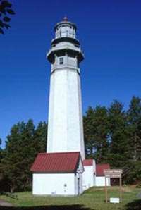 | 123 123 ft (37 m) | 1898 | | | Active |
| Lime Kiln Light | San Juan Island | 48°30′58″N 123°09′09″W / 48.5160°N 123.1524°W / 48.5160; -123.1524 (Lime Kiln Light) |  | 055 55 ft (17 m) | 1919 | 1962 | | Active |
| Marrowstone Point Light | Fort Flagler | 48°06′06″N 122°41′16″W / 48.1016°N 122.6879°W / 48.1016; -122.6879 (Marrowstone Point Light) |  | 028 28 ft (8.5 m) | 1888/1918[10][note 3] | 1962 | | Active |
| Mukilteo Light | Mukilteo, Washington | 47°56′55″N 122°18′22″W / 47.9487°N 122.3062°W / 47.9487; -122.3062 (Mukilteo Light) |  | 033 33 ft (10 m) | 1906 | 1979 | | Active/museum |
| New Dungeness Light | Dungeness Spit | 48°10′54″N 123°06′37″W / 48.1817°N 123.1103°W / 48.1817; -123.1103 (New Dungeness Light) | .jpg) | 067 67 ft (20 m) | 1857 | 1994[11] | | Active |
| North Head Light | Ilwaco, Washington | 46°17′56″N 124°04′41″W / 46.2989°N 124.0780°W / 46.2989; -124.0780 (North Head Light) |  | 194 194 ft (59 m) | 1898 | 1961 | | Active |
| Patos Island Light | Patos Island | 48°47′20″N 122°58′17″W / 48.7890°N 122.9713°W / 48.7890; -122.9713 (Patos Island Light) | 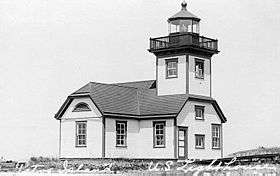 | 052 52 ft (16 m) | 1893/1908[12] | 1974 | | Active |
| Point No Point Light | Point No Point, Washington | 47°54′44″N 122°31′36″W / 47.9122°N 122.5268°W / 47.9122; -122.5268 (Point No Point Light) |  | 027 27 ft (8.2 m) | 1879 | 1977 | | Active |
| Point Robinson Light | east point of Maury Island | 47°23′17″N 122°22′28″W / 47.3881°N 122.3744°W / 47.3881; -122.3744 (Point Robinson Light) |  | 040 40 ft (12 m) | 1887/1915[13] | 1978 | | Active |
| Point Wilson Light | Point Wilson north of Port Townsend, Washington | 48°08′39″N 122°45′17″W / 48.1442°N 122.7548°W / 48.1442; -122.7548 (Point Wilson Light) |  | 051 51 ft (16 m) | 1879/1914 | 1977 | | Active |
| Semiahmoo Harbor Light | Semiahmoo Bay near Blaine, Washington | 48°59′32″N 122°47′02″W / 48.9923°N 122.7840°W / 48.9923; -122.7840 (Semiahmoo Harbor Light) |  | | 1905 | | 1944 | Replaced with automated light |
| Slip Point Light | Clallam Bay | 48°15′52″N 124°15′04″W / 48.2645°N 124.251°W / 48.2645; -124.251 (Slip Point Light)[14] |  | 055 55 ft (17 m)[15] | 1905/1951[14] | 1977[14] | ca. 2000[14] | Tower demolished;
keeper's dwelling remains |
| Smith Island Light | Smith Island | 48°19′06″N 122°50′38″W / 48.3184°N 122.8438°W / 48.3184; -122.8438 (Smith Island Light) |  | 097 97 ft (30 m) | 1858[2] | 1957[2] | 1998[16] | Replaced by automated tower |
| Turn Point Light | NW point of Stuart Island | 48°41′20″N 123°14′15″W / 48.6888°N 123.2374°W / 48.6888; -123.2374 (Turn Point Light) | .jpg) | 044 44 ft (13 m) | 1893/1936 | 1974 | | Active |
| West Point Light | West Point in Seattle | 47°39′43″N 122°26′09″W / 47.6620°N 122.4357°W / 47.6620; -122.4357 (West Point Light) |  | 027 27 ft (8.2 m) | 1881 | 1984 | | Active |
| Willapa Bay Light | north of entrance to Willapa Bay | 46°43′N 124°05′W / 46.71°N 124.08°W / 46.71; -124.08 (Willapa Bay Light) (est.) |  | 081 81 ft (25 m)[17] | 1858[18] | | 1938[18] | Demolished |
Notes
- ↑ If there is a second date, it represents the date the most recent tower was lit.
- ↑ Current aid by this name is on adjacent skeleton tower.
- ↑ Light was moved to concrete tower in 1902; it as moved again to the roof of the 1918 fog signal building at an unknown date.
References
- 1 2 "Historic Light Station Information and Photography: Washington". United States Coast Guard Historian's Office.
- 1 2 3 4 "Lighthouses of the United States: Washington". Russ Rowlett.
- ↑ Light List, Volume VI, Pacific Coast and Pacific Islands (PDF). Light List. United States Coast Guard. 2012.
- ↑ "Admiralty Head, WA". LighthouseFriends.
- 1 2 "Cattle Point, WA". LighthouseFriends.
- 1 2 "Destruction Island, WA". LighthouseFriends.
- ↑ Columbia River to Destruction Island (Map). 1:180,789. NOAA. 2004. 18500.
- 1 2 "Dofflemyer Point, WA". LighthouseFriends.
- 1 2 "Ediz Hook, WA". LighthouseFriends.
- ↑ "Marrowstone Point, WA". LighthouseFriends.
- ↑ "New Dungeness, WA". LighthouseFriends.
- ↑ "Patos Island, WA". LighthouseFriends.
- ↑ "Point Robinson, WA". LighthouseFriends.
- 1 2 3 4 "Slip Point, WA". LighthouseFriends.
- ↑ Strait of Juan de Fuca Entrance (Map). 1:100,000. NOAA. 1998. Chart 18460.
- ↑ Nelson, Sharlene (January 1999). "And, now there are three: The Demise of the Smith Island Light". Lighthouse Digest.
- ↑ Willapa Bay (Map). 1:40,000. US Dept. of Commerce. 1928. Chart 6185.
- 1 2 Harrison, Tim; Jones, Ray (2000). "willapa+bay"+lighthouse Lost Lighthouses. Guilford, Connecticut: Globe Pequot Press.