List of key MBTA bus routes

Key bus routes of the Massachusetts Bay Transportation Authority (MBTA) system are 15 routes that have high ridership and higher frequency standards than other bus lines, according to the 2006 MBTA Service Policy. These key bus routes ensure basic geographic coverage with frequent service in the densest areas of the city, and connect to other MBTA services to give access to other areas throughout the region.[1]
In recognition of their function as part of the backbone MBTA service, the key bus routes have been added to newer basic route maps installed in subway stations and other public locations. These schematic route maps show the rail rapid transit routes, bus rapid transit routes, commuter rail services, and key bus routes.
In April 2014, extended late-night service on the key bus routes and rapid transit routes was announced, to be operated on a one-year trial basis with service continuation depending on late-night ridership and on corporate sponsorship.[2] As of April 2015, late-night service was cut back from 2:30am to 2:00am, and extended hours were dropped from 5 of the 15 key bus routes.[3]
History

In November 2006, the MBTA launched a concerted effort to improve service quality on key bus routes,[4] which has since been completed. The 2008 Service Plan recommended improvements for various lines, including upgrading the 31 bus to Key Route standards.[5] A second round of improvements, entitled the Key Routes Improvement Project has been funded by the American Recovery and Reinvestment Act of 2009. The Silver Line services were formerly considered part of the program, but were split off into a separate enhancement project.
Route list
The key routes are the 1, 15, 22, 23, 28, 32, 39, 57, 66, 71, 73, 77, 111, 116, and 117.
1
The 1 Harvard/Holyoke Gate - Dudley Station via Massachusetts Avenue runs mostly along Massachusetts Avenue, from Harvard, past the Massachusetts Institute of Technology, over the Charles River via the Harvard Bridge into Boston, past Berklee College of Music to Boston Medical Center, then southwest to Dudley via Albany Street and Melnea Cass Boulevard. Limited stop service over most of the route is provided by the CT1.
The 1 Harvard-Dudley via Massachusetts Avenue was formed in September 1962 when two routes, split at Massachusetts Avenue (now Hynes Convention Center), were merged - the 76 Harvard-Massachusetts Station and the 47 Massachusetts Station-Dudley. In May 1987 the route was realigned from its former alignment on Washington Street southeast several blocks onto Albany Street and Melnea Cass Boulevard to serve Boston Medical Center.
The City of Cambridge plans to install signal priority on the #1 route at some intersections.[6]
15
The 15 Kane Square - Ruggles Station via Uphams Corner route runs from Kane Square, several blocks west of Savin Hill, west on Hancock Street and Dudley Street past Uphams Corner to Dudley, continuing west on Malcolm X Boulevard to Roxbury Crossing and north on Tremont Street to Ruggles.
Certain late runs are extended to Fields Corner to replace #19 service, which does not run after the evening rush hour.
Buses started running on the 15 Kane Square-Dudley via Uphams Corner and Dudley Street on April 6, 1962, replacing trackless trolleys. With the opening of the new Orange Line in May 1987, the route was extended to Ruggles.
22

The 22 Ashmont Station - Ruggles Station via Talbot Avenue & Jackson Square begins at Ashmont and runs northwest on Talbot Avenue, north on Blue Hill Avenue, and northwest on Seaver Street to the former site of Egleston station. From there it continues north on Columbus Avenue and Tremont Street past two Orange Line stations - Jackson Square and Roxbury Crossing - before ending at another one, Ruggles.
Buses replaced trackless trolleys on the 22 on April 6, 1962, running as the 22 Ashmont-Dudley via Talbot and Warren. This route, rather than turning off Blue Hill Avenue onto Seaver Street, continued north a bit further and then went north on Warren Street to end at Dudley. The opening of the new Orange Line in May 1987 resulted in the realignment to the current route.
23

The 23 Ashmont Station - Ruggles Station via Washington Street has the same endpoints as the 22, but uses a mostly different route. It starts out of Ashmont on Talbot Avenue (Boston), but turns north on Washington Street, following that onto Warren Street to Dudley. From Dudley the 23 heads west on Malcolm X Boulevard to Roxbury Crossing and north on Tremont Street to Ruggles.
Buses replaced trackless trolleys on April 7, 1962 on the 22 Ashmont-Dudley via Washington Street (Dorchester) and Warren. It was extended to Ruggles in May 1987 along with the opening of the new Orange Line.
28
The 28 Mattapan Station - Ruggles Station via Dudley Station began its history as Route 28 Arborway-Mattapan via Cummins Highway. This route, which paralleled Route 32 to Forest Hills and Arborway and was used during rush hours only, was discontinued in 1981.
Route 29 (Mattapan-Egleston via Blue Hill Ave - Seaver St) handled all service on Blue Hill Avenue until a new version of Route 28 was established in 1987. This new Route 28 served between Mattapan station and the new Orange Line station at Ruggles, and in turn took over all service. Route 29 was relegated to a rush-hours only route, but only to Jackson Square. Late night service does run to Ruggles, but Route 28 handles all service throughout the week. Until 2003 it operated out of the Bartlett garage; when Arborway opened in 2003, Route 28 was shifted to the Cabot garage.
32
The 32 Wolcott Square - Forest Hills Station via Hyde Park Avenue routes runs along Hyde Park Avenue from Forest Hills to Readville, serving Jamaica Plain, Roslindale, and Hyde Park. It parallels the commuter rail tracks from Forest Hills to Readville for its entire route.
Up until 1953, Route 32 was a full-service trolley route from Forest Hills to Cleary Square, until it converted to trackless trolleys. In 1958, all trackless trolley services south of Forest Hills were discontinued and replaced by diesel buses. (The trolleys ended in the middle of Hyde Park Ave; however, a loop for the trackless trolleys to turn around was placed on Hyde Park Avenue and Pine St.)
In 1981, the former Route 31 bus route between Mattapan Square and Wolcott Square was consolidated with Route 32 at Cleary Sq to become Route 32 Forest Hills-Wolcott Square. (Route 50, which served Cleary Square and Forest Hills via Roslindale, was rerouted onto River St, Gordon Avenue, Summer St (inbound) and Austin St (outbound) to serve the Summer St Elderly Housing Area (aka Malone Elderly Housing).

39
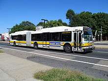
The 39 Forest Hills - Back Bay via Huntington Avenue route is the replacement (originally described as "temporary") for Green Line "E" Branch service from Heath Street to Arborway which has run since December 1985. Aside from paralleling the Green Line from Heath Street to Copley, there are connections to the Orange Line and commuter rail at both ends (and Amtrak at the latter). Route 39 was the first MBTA route to regularly use articulated buses , which were later introduced to several other routes (including the #28) in late 2005.
57
The 57 Watertown Yard - Kenmore Station route is the replacement for the Green Line "A" Branch service which was discontinued in 1969. Route 57 was formerly one of the few routes that ran limited-stop service in the Boston city limits (no pickups were made on Commonwealth Avenue between Packard's Corner and Kenmore), but this practice was discontinued in December 2006.
66
The 66 Harvard Square - Dudley Station via Allston & Brookline Village route begins at Dudley Square in Roxbury and parallels Route 39 from Brigham Circle to the Boston city limits. Via Harvard Street, this bus serves Brookline and Allston before terminating at Harvard Square, Cambridge. It connects Dudley Station on the Silver Line to Roxbury Crossing on the Orange Line, as well as Fenwood Rd, Mission Park and Riverway on the Green Line "E" Branch, Brookline Village on the Green Line "D" Branch, Coolidge Corner on the Green Line "C" Branch, Harvard Ave on the Green Line "B" Branch and Harvard on the Red Line. The 66 is a major route for high school students as it is convenient for students from Boston Latin School and The John D. O'Bryant School of Mathematics & Science.
71
The 71 Watertown Square - Harvard Station via Mt. Auburn Street and 73 Waverley Square - Harvard Station via Trapelo Road are a pair of trackless trolley routes which run out of the Harvard Bus Tunnel. They represent some of the last vestiges of Boston's once-extensive trolley and trackless trolley network. Both cover parts of Mount Auburn Street; the trolleys are also used on the 72 route and the 77A route to North Cambridge.
73
The 73 Waverley Square - Harvard Station via Trapelo Road begins in the Harvard Bus Tunnel and runs concurrent with the 71 bus along Mount Auburn Street in Cambridge and Watertown. The route 73 bus splits with the route 71 bus, and travels along Belmont Street and Trapelo Road in Watertown and Belmont.
Until the 1950s, streetcars served this route. Starting in 1957, trackless trolleys provided short-turn service from Harvard to Benton Square. The entirety of Route 73 was converted from streetcars to trackless trolleys in 1958. The Benton Square short-turn service ended in 1970. The new Harvard Bus Tunnel was completed in 1985.[7]
77
The 77 Arlington Heights - Harvard Station via Massachusetts Avenue route runs from Arlington Heights to Harvard Station along Massachusetts Avenue. The 77A short turn routing, which terminates at North Cambridge Carhouse instead of Arlington Heights, is used to transport 71 and 73 trolleybuses to/from Harvard Square at the beginning and end of service.
111

The 111 Woodlawn or Broadway & Park Ave. - Haymarket Station via Mystic River/Tobin Bridge provides a route between downtown Boston and parts of Chelsea. It begins at Haymarket, running along Washington Street North and over the Charlestown Bridge to City Square. It takes the ramps onto the Tobin Bridge into Chelsea, exiting and running through downtown Chelsea before heading north to end at Woodlawn, just over the Everett border. Some trips continue east on Park Avenue to end at Broadway in Revere. When the BERy bought the route in 1936, it ran as streetcars between Chelsea Square and Woodlawn. On October 10, 1936, the line was replaced by an extension of the City Square - Chelsea Square bus. The line was extended in April 1975 to Haymarket, with the closure of the Charlestown Elevated; the partial extension beyond Woodlawn was done in January 2001.
The 111 is among the most frequent numbered MBTA bus routes, with service running every 5 minutes during rush hour.
116/117
The 116 Wonderland Station - Maverick Station via Revere Street and 117 Wonderland Station - Maverick Station via Beach Street routes share most of their routes through East Boston and Revere, differing only on the northern end near Wonderland. They operate on 20-minute headways during peak hours, for an effective 10-minute combined headway on the shared segment on Meridian Street and Broadway.
See also
- List of MBTA bus routes
- MBTA crosstown bus routes
- MBTA Silver Line (formerly considered part of the key routes)
References
- ↑ "Service Delivery Policy" (PDF). MBTA. 2006-07-13. pp. 3, 26–27. Retrieved 2008-10-31.
- ↑ Annear, Steve (March 13, 2014). "Date Set For New Late-Night MBTA Service". Boston. Boston Magazine. Retrieved 2014-03-15.
- ↑ Dumcius, Gintautas. "MBTA Scaling Back Late-Night Service". 90.9 WBUR. Retrieved 2015-04-20.
- ↑ "Key Bus Routes Improvement Program" (PDF). LivableStreets. November 2006. Retrieved 2008-10-31.
- ↑ "Preliminary 2008 Service Plan" (PDF). MBTA. Fall 2008. p. 8. Retrieved 2008-10-31.
- ↑ Levy, Marc (2 December 2015). "Fewer red lights for No. 1 Bus commuters could be just a start for city's street transit". Cambridge Day. Retrieved 3 December 2015.
- ↑ "Changes to Transit Service in the MBTA district" (PDF). Jonathan Belcher. 2014. p. 57. Retrieved 2015-02-10.
External links
| Wikimedia Commons has media related to MBTA key bus routes. |
| Subway lines (List of stations) |
| |||||||||||
|---|---|---|---|---|---|---|---|---|---|---|---|---|
| Commuter Rail lines (List of stations) |
| |||||||||||
| Bus routes (List of routes) | ||||||||||||
| Other services | ||||||||||||
| Component parts of system lines | ||||||||||||
| Capital projects |
| |||||||||||
| History |
| |||||||||||
| Other | ||||||||||||