List of Interstate Highways
| Dwight D. Eisenhower National System of Interstate and Defense Highways | |
|---|---|
|
Highway shield for Interstate 90 and the Eisenhower Interstate System | |
|
Interstate Highways in the 48 contiguous states | |
| System information | |
| Formed: | June 29, 1956[1] |
| Highway names | |
| Interstates: | Interstate X (I-X) |
| System links | |


Primary Interstate Highways of the United States are numbered with one- or two-digit designations. Their associated auxiliary highways have three-digit numbers. Generally, odd-numbered routes run north-south, with lower numbers in the west and higher numbers in the east; even-numbered routes run east-west, with lower numbers in the south and higher numbers in the north. Routes divisible by "5" (for example, I-40 or I-75) are major routes, often running coast-to-coast or border-to-border.
Five pairs of numbers are duplicated throughout the system; the corresponding highways are separated by large distances which prevent confusion. Below, these are differentiated from each other by "West" and "East". The main list is followed by sections listing the primary Interstate highways in Alaska, Hawaii, and Puerto Rico.
Primary Interstate Highways
There are 67 primary Interstate Highways listed in the table below, and 43 of them have auxiliary routes.
| Number | Length (mi)[2] | Length (km) | Southern or western terminus | Northern or eastern terminus | Formed | Removed | Notes |
|---|---|---|---|---|---|---|---|
| 46.8 | 75.3 | Palmview, Texas (US 83) | Harlingen, Texas (I-69E / US 77 / US 83) | 2013 | current | Texas only Associated routes: none | |
| 132.3 | 212.9 | Tampa, Florida (I-275) | Daytona Beach, Florida (I-95 / SR 400) | 1957 | current | Florida only Associated routes: none | |
| 1,381.29 | 2,222.97 | San Ysidro, California (MX-1 in Mexico) | Blaine, Washington (BC 99 in Canada) | 1956 | current | 3 states served: CA, OR, WA Associated routes: I-105, I-205, I-305, I-405, I-505, I-605, I-705, I-805; Future: I-905 | |
| 348.25 | 560.45 | San Diego, California (Sunset Cliffs Boulevard / Nimitz Boulevard) | Casa Grande, Arizona (I-10) | 1964 | current | 2 states served: CA, AZ Associated routes: none | |
| 2,460.34 | 3,959.53 | Santa Monica, California (SR 1) | Jacksonville, Florida (I-95 / US 17 / SR 228) | 1957 | current | 8 states served: CA, AZ, NM, TX, LA, MS, AL, FL Associated routes: I-110, I-210, I-310, I-410, I-510, I-610, I-710, I-910 | |
| 85.59 | 137.74 | Baton Rouge, Louisiana (I-10) | Slidell, Louisiana (I-10 / I-59) | 1967 | current | Louisiana only Associated routes: none | |
| 1,433.52 | 2,307.03 | San Diego, California (I-8 / SR 15) | Sweetgrass, Montana (Hwy 4 in Canada) | 1957 | current | 6 states served: CA, NV, AZ, UT, ID, MT Associated routes: I-115, I-215, I-315, I-515 | |
| 166.81 | 268.45 | Macon, Georgia (I-75) | Savannah, Georgia (US 17 / GA 404 / Montgomery Street) | 1972 | current | Georgia only Associated route: I-516 | |
| 145.76 | 234.58 | Phoenix, Arizona (I-10) | Flagstaff, Arizona (I-40 / AZ-89A) | 1961 | current | Arizona only Associated routes: none | |
| 63.6 | 102.4 | Nogales, Arizona (MX-15 in Mexico) | Tucson, Arizona (I-10) | 1972 | current | Arizona only Associated routes: none | |
| 1,539.38 | 2,477.39 | between Kent, Texas and Toyah, Texas (I-10) | Florence, South Carolina (I-95) | 1957 | current | 6 states served: TX, LA, MS, AL, GA, SC Associated routes: I-220, I-520, I-820 | |
| 124.70 | 200.69 | Memphis, Tennessee (I-55 / I-40) | Birmingham, Alabama (I-65 / US 31) | 2012 | current | 3 states served: Mississippi, Alabama, Tennessee Planned associated routes: I-222, I-422 | |
| 316.36 | 509.13 | Pulley's Mill, Illinois (I-57) | Chattanooga, Tennessee (I-75) | 1962 | current | 4 states served: Illinois, Kentucky, Tennessee, Georgia Associated route: I-124 | |
| 1,062.77 | 1,710.36 | Las Cruces, New Mexico (I-10 / US 85 / US 180) | Buffalo, Wyoming (I-90 / US 87) | 1957 | current | 3 states served: New Mexico, Colorado, Wyoming Associated route: I-225 | |
| 305.62 | 491.85 | Kingsport, Tennessee (US 11W) | Charleston, South Carolina (US 17) | 1960 | current | 3 states served: Tennessee, North Carolina, South Carolina Associated routes: I-126, I-526 | |
| 124.13 | 199.77 | Lubbock, Texas (US 87 / Loop 289) | Amarillo, Texas (I-40 / US 87 / US 287) | 1969 | current | Texas only Associated routes: none | |
| 755.51 | 1,215.88 | Kansas City, Missouri (I-35 / I-70) | Pembina, North Dakota (US 81 and PTH 29 in Canada) | 1958 | current | 4 states served: Missouri, Iowa, South Dakota, North Dakota Associated routes: I-129, I-229 | |
| 366.76 | 590.24 | Fort Worth, Texas (I-20) | North Little Rock, Arkansas (I-40 / US 65 / US 67 / US 167) | 1957 | current | 2 states served: Texas, Arkansas Associated routes: I-430, I-530, I-630; Planned: I-130 | |
| 1,568.38 | 2,524.06 | Laredo, Texas (US 83 / SH 359 / BS I-35 as well as MX-85 in Mexico) | Duluth, Minnesota (MN-61 / LSCT / 26th Avenue) | 1956 | current | 6 states served: TX, OK, KS, MO, IA, MN Associated routes: I-35E, I-35W, I-135, I-235, I-335, I-435, I-535, I-635 | |
| 143.00 | 230.14 | Corpus Christi, Texas (US 181) | San Antonio, Texas (I-35 / US 281) | 1959 | current | Texas only Associated routes: none | |
| 306.14 | 492.68 | Normal, Illinois (I-55) | Wausau, Wisconsin (WIS 29 / US-51) | 1984 | current | 2 states served: Illinois, Wisconsin Associated routes: none | |
| 2,555.10 | 4,112.03 | Barstow, California (I-15) | Wilmington, North Carolina (US 117 / NC 132) | 1964 | current | 8 states served: CA, AZ, NM, TX, OK, AR, TN, NC Associated routes: I-140, I-240, I-440, I-540, I-640, I-840 | |
| 176.33 | 283.78 | Russell, Illinois (I-94 / US 41) | Howard, Wisconsin (I-43) | 2015 | current | 2 states served: Illinois, Wisconsin Associated routes: none | |
| 191.55 | 308.27 | Beloit, Wisconsin (I-39 / I-90) | Howard, Wisconsin (US 41 / US 141 / I-41) | 1981 | current | Wisconsin only Associated routes: none | |
| 633.79 | 1,019.99 | Wichita Falls, Texas (US 82 / US 277 / US 281 / US 287) | St. Louis, Missouri (I-70) | 1958 | current | 3 states served: Texas, Oklahoma, Missouri Associated routes: I-244, I-444 | |
| 284.91 | 458.52 | Galveston, Texas (TX 87) | Dallas, Texas (I-30) | 1971 | current | Texas only Associated route: I-345 | |
| 388.25 | 624.83 | New Orleans, Louisiana (I-10 future) | Kansas City, Missouri (I-435) | 1984 | current | Unfinished Louisiana-Arkansas section: Blanchard, Louisiana (LA 1) to Texarkana, Arkansas (US 59 / US 71) 3 states served: Louisiana, Arkansas, Missouri Associated routes: none | |
| 964.25 | 1,551.81 | Laplace, Louisiana (I-10) | Chicago, Illinois (US 41, Lake Shore Drive) | 1960 | current | 6 states served: LA, MS, TN, AR, MO, IL Associated routes: I-155, I-255, I-355; I-555 | |
| 386.12 | 621.40 | Miner, Missouri (I-55) | Chicago, Illinois (I-94) | 1965 | current | 2 states served: Missouri, Illinois Associated routes: none | |
| 445.23 | 716.53 | Slidell, Louisiana (I-10 / I-12) | Lookout Mountain, Georgia (I-24) | 1960 | current | 4 states served: Louisiana, Mississippi, Alabama, Georgia Associated routes: I-359, I-459, I-759 | |
| 953.74 | 1,534.90 | Wentzville, Missouri (I-70) | Chesapeake, Virginia (I-264 / I-664) | 1961 | current | 6 states served: MO, IL, IN, KY, WV, VA Associated routes: I-264, I-464, I-564, I-664 | |
| 887.30 | 1,427.97 | Mobile, Alabama (I-10) | Gary, Indiana (I-90) | 1958 | current | 4 states served: Alabama, Tennessee, Kentucky, Indiana Associated routes: I-165, I-265, I-465, I-565, I-865 | |
| 76.28 | 122.76 | Front Royal, Virginia (I-81) | Washington, D.C. (US 29) | 1982 | current | 2 states served: Virginia, District of Columbia Associated routes: none | |
| 112.9 | 181.7 | Morgantown, West Virginia (I-79) | Hancock, Maryland (I-70) | 1991 | current | 2 states served: West Virginia, Maryland Associated routes: none | |
| 705.40 | 1,135.23 | Victoria, Texas (I-69E / US 77 future & I-69W / US 59 future) | Port Huron, Michigan (Hwy 402 in Canada) | 1957 | current | Unfinished Texas section: Rosenberg (US-59 / Spur 529) to Splendora (US 59 / Mandell Road) Unfinished Mississippi-Tennessee section: Banks, Mississippi (MS 304 / MS 713) to Frayser, Tennessee (US 51 / TN 3) Unfinished Indiana section: Elberfeld, Indiana (I-64) to Scotland, Indiana (US 231) 6 states served: TX, MS, TN, KY, IN, MI. Planned/started in 2 more: LA, AR Associated routes: I-69C, I-69E, I-69W, I-169, I-269, I-369, I-469; Planned: I-169 in Tennessee, I-369 in Kentucky | |
| 2,153.13 | 3,465.13 | Cove Fort, Utah (I-15) | Baltimore, Maryland (Park and ride) | 1956 | current | 10 states served: UT, CO, KS, MO, IL, IN, OH, WV, PA, MD Associated routes: I-170, I-270, I-370, I-470, I-670 | |
| 343.78 | 553.26 | Louisville, Kentucky (I-64) | Cleveland, Ohio (I-90) | 1959 | current | 2 states served: Kentucky, Ohio Associated routes: I-271, I-471 | |
| 179.29 | 288.54 | Hannibal, Missouri (US 61) | Champaign, Illinois (I-57) | 1970 | current | 2 states served: Missouri, Illinois Associated route: I-172 | |
| 1,188.3 | 1,912.4 | Briarcliffe Acres, South Carolina (US 17 future) | Sault Ste. Marie, Michigan (Canada future) | 1997 | current | 6 states served: MI (future), OH (future), WV (future), VA (future), NC, SC (future) Associated routes: none | |
| 440.91 | 709.58 | Bettendorf, Iowa (I-80) | Garden City, South Carolina (US 17 Bus. future) | 1974 | current | 8 states served: IA, IL, IN, OH, WV (future), VA (future), NC, SC (future) Associated routes: I-274 (future), I-474 | |
| 1,786.47 | 2,875.04 | Hialeah, Florida (SR 826) | Sault Ste. Marie, Michigan (Canada) | 1958 | current | 6 states served: FL, GA, TN, KY, OH, MI Associated routes: I-175, I-275, I-375, I-475, I-575, I-675 | |
| 187.34 | 301.49 | West Denver, Colorado (I-70) | Big Springs, Nebraska (I-80) | 1975 | current | 2 states served: Colorado, Nebraska Associated routes: none | |
| 434.36 | 699.03 | East Westfield Center, Ohio (I-71) | Camden, New Jersey (I-295) | 1976 | current | 3 states served: Ohio, Pennsylvania, New Jersey Associated routes: I-176, I-276, I-376, I-476, I-676; Future: I-576 | |
| 610.10 | 981.86 | Columbia, South Carolina (I-26) | Cleveland, Ohio (I-90) | 1958 | current | 5 states served: South Carolina, North Carolina, Virginia, West Virginia, Ohio Associated route: I-277 | |
| 143.56 | 231.04 | Union Township, Pennsylvania (I-81) | New York City | 1957 | current | 3 states served: Pennsylvania, New Jersey, New York Associated routes: I-278, I-478, I-678, I-878 | |
| 343.24 | 552.39 | Charleston, West Virginia (I-77) | Erie, Pennsylvania (PA-5) | 1967 | current | 2 states served: West Virginia, Pennsylvania Associated routes: I-279, I-579 | |
| 2,899.54 | 4,666.36 | San Francisco, California (US 101) | Fort Lee, New Jersey (I-95) | 1956 | current | 11 states served: CA, NV, UT, WY, NE, IA, IL, IN, OH, PA, NJ Associated routes: I-180, I-238 I-280, I-380, I-480, I-580, I-680, I-780, I-880, I-980 | |
| 854.89 | 1,375.81 | Dandridge, Tennessee (I-40) | Fisher's Landing, New York (Canada) | 1961 | current | 6 states served: TN, VA, WV, MD, PA, NY Associated routes: I-381, I-481, I-581, I-781 | |
| 143.58 | 231.07 | Ellensburg, Washington (I-90) | Hermiston, Oregon (I-84) | 1956 | current | 2 states served: Washington, Oregon Associated route: I-182 | |
| 85.3 | 137.3 | Baltimore, Maryland | Harrisburg, Pennsylvania (I-81) | 1959 | current | 2 states served: Maryland, Pennsylvania Associated route: I-283 | |
| 769.62 | 1,238.58 | West Portland, Oregon (I-5) | Echo, Utah (I-80) | 1980 | current | 3 states served: Oregon, Idaho, Utah Associated route: I-184 | |
| 232.4 | 374.0 | East Scranton, Pennsylvania (I-81) | Sturbridge, Massachusetts (I-90) | 1963 | current | 4 states served: Pennsylvania, New York, Connecticut, Massachusetts Associated routes: I-384, I-684 | |
| 668.75 | 1,076.25 | Montgomery, Alabama (I-65) | Petersburg, Virginia (I-95) | 1958 | current | 5 states served: Alabama, Georgia, South Carolina, North Carolina, Virginia Associated routes: I-185, I-285, I-385, I-485, I-585, I-785, I-985; Planned: I-685 | |
| 62.85 | 101.15 | West Heyburn, Idaho (I-84) | Pocatello, Idaho (I-15) | 1980 | current | Idaho only Associated routes: none | |
| 183.56 | 295.41 | East Erie, Pennsylvania (I-90) | Woodbury, New York (I-87 future) | 1999 | current | 2 states served: Pennsylvania, New York Associated routes: none | |
| 333.49 | 536.70 | New York City (I-278) | Champlain, New York (A-15 in Canada) | 1957 | current | New York only Associated routes: I-287, I-587, I-787 | |
| 140.6 | 226.3 | West Barstow, Illinois (I-80) | Hillside, Illinois (I-290) | 1987 | current | Illinois only Associated routes: none | |
| 117.75 | 189.50 | East Binghamton, New York (I-81) | Schenectady, New York (I-90) | 1968 | current | New York only Associated routes: none | |
| 191.12 | 307.58 | Bow, New Hampshire (I-93) | Highgate Springs, Vermont (Route 133 in Canada / future A-35) | 1960 | current | 2 states served: New Hampshire, Vermont Associated route: I-189 | |
| 3,020.54 | 4,861.09 | Seattle, Washington (WA 519) | Boston, Massachusetts (MA 1A) | 1956 | current | 13 states served: WA, ID, MT, WY, SD, MN, WI, IL, IN, OH, PA, NY, MA Associated routes: I-190, I-290, I-390, I-490, I-590, I-690, I-790, I-890, I-990 | |
| 290.37 | 467.31 | New Haven, Connecticut/North Haven, Connecticut (I-95) | Derby Line, Vermont (A-55 in Canada) | 1958 | current | 3 states served: Connecticut, Massachusetts, Vermont Associated routes: I-291, I-391, I-691 | |
| 189.95 | 305.69 | Canton, Massachusetts (I-95) | St. Johnsbury, Vermont (I-91) | 1957 | current | 3 states served: Massachusetts, New Hampshire, Vermont Associated routes: I-293, I-393 | |
| 1,585.20 | 2,551.13 | Billings, Montana (I-90) | Port Huron, Michigan (Hwy 402 in Canada) | 1956 | current | 7 states served: MT, ND, MN, WI, IL, IN, MI Associated routes: I-194, I-294, I-394, I-494, I-694, I-794, I-894 | |
| 1,925.74 | 3,099.18 | Miami, Florida (US 1) | Houlton, Maine (Route 95 in Canada) | 1957 | current | 15 states served: FL, GA, SC, NC, VA, MD, DE, PA, NJ, NY, CT, RI, MA, NH, ME Associated routes: I-195, I-295, I-395, I-495, I-595, I-695, I-795, I-895 | |
| 192.06 | 309.09 | Muskegon, Michigan (US 31) | Detroit, Michigan (I-75) | 1959 | current | Michigan only Associated routes: I-196, I-296, I-496, I-696 | |
| 17.62 | 28.36 | Annapolis, Maryland (US 50) | Baltimore, Maryland (I-695 / I-895) | 1987 | current | Maryland only Associated routes: none | |
| 98.86 | 159.10 | Bedford, Pennsylvania (I-70 / I-76) | Painted Post, New York (I-86) | 1998 | current | Unfinished Pennsylvania section: Bellefonte, Pennsylvania (I-80) to New York border near Lawrenceville, Pennsylvania (US 15) 2 states served: Pennsylvania, New York Associated routes: none |
Other Interstate Highways
In addition to the 48 contiguous states, Interstate Highways are found in Hawaii, Alaska, and Puerto Rico. The Federal Highway Administration funds four routes in Alaska and three routes in Puerto Rico under the same program as the rest of the Interstate Highway System. However, these routes are not required to meet the same standards as the mainland routes:
| “ | Highways on the Interstate System in Alaska and Puerto Rico shall be designed in accordance with such geometric and construction standards as are adequate for current and probable future traffic demands and the needs of the locality of the highway.[3] | ” |
Hawaii
The Interstate Highways in the island of Oʻahu, Hawaii are signed with the standard Interstate Highway shield, with the letter "H-" prefixed before the number. They are fully controlled-access routes built to the same standards as the mainland Interstate Highways.
| Number | Length (mi)[2] | Length (km) | Southern or western terminus | Northern or eastern terminus | Formed | Removed | Notes |
|---|---|---|---|---|---|---|---|
| 27.16 | 43.71 | Route 93 in Kapolei | Route 72 in Honolulu | 1959 | current | Associated route: H-201 | |
| 8.33 | 13.41 | H-1 in Pearl City | Route 99 in Wahiawa | 1976 | current | ||
| 15.32 | 24.66 | H-1 & H-201 in Halawa | Marine Corps Base Hawaii | 1997 | current |
Alaska
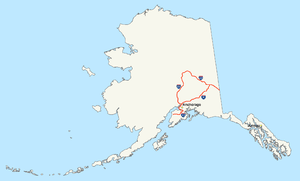
Alaska's Interstate Highways are unsigned, although they all have state highway numbers that do not match the Interstate Highway numbers.[4]
| Number | Length (mi)[2] | Length (km) | Southern or western terminus | Northern or eastern terminus | Formed | Removed | Notes |
|---|---|---|---|---|---|---|---|
| 408.23 | 656.98 | Anchorage | Canadian border in Alcan Border | 1976 | current | Glenn Highway, Richardson Highway, Tok Cut-Off, Alaska Highway[5][6][7][8] | |
| 202.18 | 325.38 | Tok | Fairbanks | 1976 | current | Alaska Highway, Richardson Highway[6][7][8] | |
| 148.12 | 238.38 | Anchorage | Soldotna | 1976 | current | Seward Highway, Sterling Highway[5][7][8] | |
| 323.69 | 520.93 | Gateway, near Palmer | Fairbanks | 1976 | current | Parks Highway[5][6][7][8] |
Puerto Rico

Like Alaska, Puerto Rico signs its Interstate Highways as territorial routes, and the numbers do not match their official Interstate Highway designations. Many of the territory's routes are freeway-standard toll roads.[9]
| Number | Length (mi)[2] | Length (km) | Southern or western terminus | Northern or eastern terminus | Formed | Removed | Notes |
|---|---|---|---|---|---|---|---|
| 71.08 | 114.39 | PR-2 in Ponce | PR-2 in San Juan (PR 22/PR 18 interchange) | — | — | ||
| 138.13 | 222.30 | PR-1 in Ponce | PR-3 in San Juan (PR 1/PR 26 interchange) | — | — | ||
| 65.27 | 105.04 | PR-3 in Humacao | PR-2 in San Juan (PR 1/PR 26/PR 66 interchange) | — | — |
In popular culture
The title of interactive fiction I-0 refers to the fictional "Interstate Zero".[10]
See also
References
- ↑ Weingroff, Richard F. (Summer 1996). "Federal-Aid Highway Act of 1956, Creating the Interstate System". Public Roads. Washington, DC: Federal Highway Administration. 60 (1). Retrieved March 16, 2012.
- 1 2 3 4 Adderley, Kevin (January 15, 2014). "Table 1: Main Routes of the Dwight D. Eisenhower National System of Interstate and Defense Highways as of December 31, 2013". Route Log and Finder List. Federal Highway Administration.
- ↑ Staff. "FHWA Route Log and Finder List". Federal Highway Administration. Retrieved May 24, 2007.
- ↑ Voss, Oscar. "Alaska Roads: Interstate ends photos". Retrieved May 24, 2007.
- 1 2 3 Witt, Jennifer W. (2010). Annual Traffic Volume Report (PDF) (Report) (2008-2009-2010 ed.). Alaska Department of Transportation & Public Facilities. Retrieved March 15, 2012.
- 1 2 3 Birkholz, Ethan (2010). Annual Traffic Volume Report (PDF) (Report) (2008-2009-2010 ed.). Alaska Department of Transportation & Public Facilities. Retrieved May 31, 2012.
- 1 2 3 4 Staff. "Dwight D. Eisenhower Interstate Routes Statewide" (PDF). Federal Highway Administration. Retrieved May 31, 2012.
- 1 2 3 4 Staff. "Alaska Department of Transportation and Public Facilities Routes by Description: CDS Route Numbers as of 28 October 2008" (PDF). Federal Highway Administration. Retrieved May 31, 2012.
- ↑ Voss, Oscar. "Puerto Rico road photos". Retrieved May 24, 2007.
- ↑ "I-0". Interactive Fiction Database. Retrieved 1 February 2016.
External links
- Alaska Roads - Interstate ends photos
- Puerto Rico road photos
- The Dwight D. Eisenhower National System of Interstate and Defense Highways Route Log and Finder List
- 3-digit Interstate Highways
| Signed | |||||||||||
|---|---|---|---|---|---|---|---|---|---|---|---|
| Unsigned | |||||||||||
| Lists |
| ||||||||||
Major Interstates highlighted | |||||||||||