List of World Heritage Sites in Canada
This is a list of World Heritage Sites in Canada. The names in the tables below are the names of the properties as used on the website of UNESCO. There are three different types of properties possible: cultural, natural, and mixed. Selection criteria i, ii, iii, iv, v, and vi are the cultural criteria, and selection criteria vii, viii, ix, and x are the natural criteria.[1] The dates for the properties on the World Heritage List are the dates of inscription, the dates for the tentative list are those of submission. The numbers are the reference numbers as used by UNESCO, and they link directly to the description pages of the properties on the UNESCO website.
Definitions
Site – official designation of the World Heritage Committee.
Location – the province or territory where the site is located, with geocoordinates. In the case of multinational or multi-regional sites, names are sorted alphabetically after being sorted by country.
Criteria – as defined by the World Heritage Committee.
Area – in hectares and acres, followed by buffer zones if applicable. A value of zero implies that no data has been published by UNESCO.
Year – during which the site was inscribed to the World Heritage Sites list.
Description – brief information about the site, including reasons for inscription.
World Heritage sites
| Site | Image | Location | Criteria | Area ha (acre) | Year | Description | Reference |
|---|---|---|---|---|---|---|---|
| Canadian Rocky Mountain Parks |  |
Alberta and British Columbia 51°25′N 116°29′W / 51.417°N 116.483°W |
Natural: (vii), (viii) |
2,306,884 (5,700,430) | 1984 [nb 1] |
With high peaks, glaciers, lakes, waterfalls, canyons and limestone caves, the National Parks that make up this site exemplify the exceptional features of the Rocky Mountains. Furthermore, one of the world's most celebrated fossil fields, the Burgess Shale Formation is located within the inscribed property. | [2] [3] |
| Dinosaur Provincial Park | 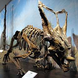 |
Alberta 50°46′4″N 111°29′32″W / 50.76778°N 111.49222°W |
Natural: (vii), (viii) |
7,493 (18,520) | 1979 | The park is noted for the beauty of its badland landscape and as a major fossil site. Specimens of every group of cretaceous dinosaurs have been found here including those of 35 species dating more than 75 million years ago. | [4] |
| Gros Morne National Park |  |
Newfoundland and Labrador 49°37′N 57°32′W / 49.617°N 57.533°W |
Natural: (vii), (viii) |
180,500 (446,000) | 1987 | With deep ocean crust and rocks of the earth's mantle lying exposed, the park illustrates continental drift. Landlocked freshwater fjords, glacier-scoured headlands in an ocean setting contribute to the natural beauty of this wilderness area. | [5] |
| Head-Smashed-In Buffalo Jump |  |
Alberta 49°44′58″N 113°37′26″W / 49.74944°N 113.62389°W |
Cultural: (vi) |
— | 1981 | The property consists of remains of a camp, of trails and a tumulus of bones of the American bison bearing testimony to nearly 6000 years of communal hunting in which the bisons were driven over a cliff, a practice known as buffalo jump. | [6] |
| Historic District of Old Québec | 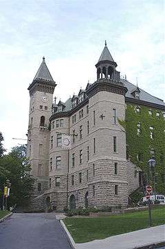 |
Quebec City, Quebec 46°48′34″N 71°12′38″W / 46.80944°N 71.21056°W |
Cultural: (iv), (vi) |
— | 1985 | Founded by the French in the 17th century, the urban ensemble of Old Québec is the most complete example of a European fortified town north of Mexico. | [7] |
| Joggins Fossil Cliffs |  |
Nova Scotia 45°42′35″N 64°26′9″W / 45.70972°N 64.43583°W |
Natural: (viii) |
689 (1,700); buffer zone 29 (72) | 2008 | This paleontological site contains the most complete terrestrial fossil record of the Carboniferous period including tracks of early animals and of the rainforest they lived in. | [8] |
| Kluane / Wrangell-St Elias / Glacier Bay / Tatshenshini-Alsek | 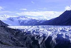 |
British Columbia and Yukon*; Alaska, United States* 61°12′N 141°0′W / 61.200°N 141.000°W |
Natural: (vii), (viii), (ix), (x) |
9,839,121 (24,313,000) | 1979 [nb 2] |
These parks comprise the world's largest non-polar icefield, some of the largest glaciers and a tectonically active mountain landscape. They are home to a number of species endangered elsewhere such as bears, wolves, caribou and Dall sheep. | [9] [10] [11] |
| Landscape of Grand-Pré |  |
Nova Scotia 45°7′6″N 64°18′26″W / 45.11833°N 64.30722°W |
Cultural: (v), (vi) |
1,323 (3,270) | 2012 | The Grand Pré landscape is an exceptional example of the adaptation of the first European settlers to the conditions of the North American Atlantic coast. The site is also inscribed as a memorial to the Acadian way of life and deportation, which started in 1755, known as the Grand Dérangement. | [12] |
| L'Anse aux Meadows National Historic Site |  |
Newfoundland and Labrador 51°28′0″N 55°37′0″W / 51.46667°N 55.61667°W |
Cultural: (vi) |
— | 1978 | These remains of an 11th-century Viking settlement are the first and only known site of Norse presence and the earliest known European settlement in America outside of Greenland. | [13] |
| Miguasha National Park | 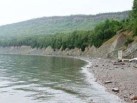 |
Gaspé Peninsula, Quebec 48°6′18″N 66°21′11″W / 48.10500°N 66.35306°W |
Natural: (viii) |
87 (210) | 1999 | [14] | |
| Mistaken Point |  |
Newfoundland and Labrador 46°37′55″N 53°11′25″W / 46.63194°N 53.19028°W |
Natural: (viii) |
570 (1,400) | 2016 |
Mistaken Point contains the oldest evidence known of early multi-cellular life on the planet with fossils an estimated 560-575 million years old. | [15] |
| Nahanni National Park | 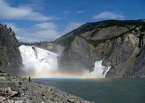 |
Northwest Territories 61°33′N 125°35′W / 61.550°N 125.583°W |
Natural: (vii), (viii) |
476,560 (1,177,600) | 1978 | [16] | |
| Old Town Lunenburg | 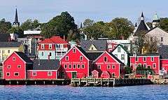 |
Nova Scotia 44°22′34″N 64°18′33″W / 44.37611°N 64.30917°W |
Cultural: (iv), (v) |
— | 1995 | [17] | |
| Red Bay Basque Whaling Station | 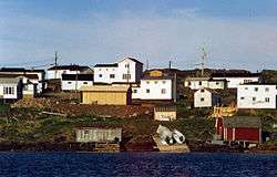 |
Red Bay, Newfoundland and Labrador 51°43′55″N 56°25′32″W / 51.73194°N 56.42556°W |
Cultural: (iii), (iv) |
313 (770) | 2013 | Between 1550 and the early 17th century, Red Bay was a major Basque whaling area. The site is home to three Basque whaling galleons and four small chalupas used in the capture of whales. The discovery of these vessels makes Red Bay one of the most precious underwater archaeological sites in the Americas. | [18] |
| Rideau Canal |  |
Ontario 45°0′N 75°46′W / 45.000°N 75.767°W |
Cultural: (i), (iv) |
21,455 (53,020); buffer zone 2,363 (5,840) | 2007 | The oldest continuously operated canal system in North America, it connects Ottawa, on the Ottawa River, to Kingston, on Lake Ontario. It opened in 1832 as a precaution in case of war with the United States; designation includes several defensive works in Kingston. The canal is still in use, with much of its original structure intact. | [19] |
| SGang Gwaay | 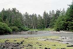 |
British Columbia 52°5′42″N 131°13′13″W / 52.09500°N 131.22028°W |
Cultural: (iii) |
— | 1981 | [20] | |
| Waterton Glacier International Peace Park | 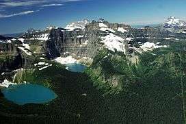 |
Alberta*; Montana, United States* 49°0′N 113°54′W / 49.000°N 113.900°W |
Natural: (vii), (ix) |
457,614 (1,130,790) | 1995 | [21] | |
| Wood Buffalo National Park |  |
Alberta and Northwest Territories 59°22′N 112°18′W / 59.367°N 112.300°W |
Natural: (vii), (ix), (x) |
4,480,000 (11,100,000) | 1983 | [22] | |
Location of sites
Tentative List
The Tentative List is an inventory of important heritage and natural sites that a country is considering for inscription on the World Heritage List. The Tentative List can be updated at any time, but inclusion on the list is a prerequisite to being considered for inscription.[23]
| Site | Image | Location | Criteria | Area ha (acre) | Year of submission | Description |
|---|---|---|---|---|---|---|
| Áísínai’pi | 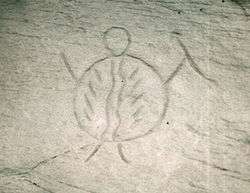 |
Alberta 49°04′55″N 111°37′01″W / 49.08194°N 111.61694°W |
Cultural: (i), (iii), (iv) |
1,780 (4,400) | 2004 |
The site contains the greatest concentration of rock art on the North American Great Plains and is sacred to the Niitsítapi (Blackfoot) people. |
| Gwaii Haanas | 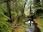 |
British Columbia 52°23′21″N 131°28′16″W / 52.38917°N 131.47111°W |
Mixed: (iii), (v), (vi), (vii), (ix), (x) |
147,000 (360,000) | 2004 |
The park reserve contains terrestrial and marine protected areas and is a testament to the rich and living heritage of the Haida people. Site encompasses existing SGang Gwaay site nominated under cultural criterion (iii) in 1981. |
| Ivvavik / Vuntut / Herschel Island (Qikiqtaruk) | 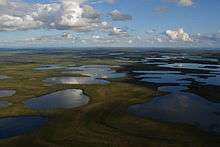 |
Yukon 69°31′11″N 139°31′30″W / 69.51972°N 139.52500°W |
Mixed: (iv), (v), (vii), (viii), (x) |
1,550,000 (3,800,000) | 2004 |
The site comprises 15 500 km2 of wilderness on the Yukon coastal plain including important wetlands. As the area was never glaciated, it contains rich archaeological and palaeontological deposits and is a key area in the history of the peopling of the Americas. It is home to 10 per cent of the world’s caribou population. |
| Pimachiowin Aki | 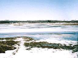 |
Manitoba and Ontario 51°N 95°W / 51°N 95°W |
Mixed: (v), (vii), (ix), (x) |
4,015,000 (9,920,000) | 2004 |
A managed landscape on the ancestral lands of five First Nations peoples. The site was submitted for consideration in 2013. The World Heritage Committee deferred inscription to give the nominators time to improve certain aspects of the bid, while also saying that the Committee needed to improve the nomination process for mixed sites as there were currently structural problems in the process that made approving mixed nominations difficult. In 2016, the Committee was set to inscribe the property on the List, but Canada requested and received a referral after Ontario's Pikangikum First Nation withdrew its support. The bid can be resubmitted by 2019.[24] |
| Quttinirpaaq |  |
Nunavut 82°13′N 72°13′W / 82.217°N 72.217°W |
Mixed: (iii), (vii), (viii), (x) |
3,777,500 (9,334,000) | 2004 |
Meaning "top of the world", Quttinirpaaq is located in the most northerly part of Canada and encompasses large amounts of Arctic desert, areas of interest to geomorphology and wildlife, and the highest mountain in eastern North America, Mount Barbeau (2,616 m). It also hosts the highest concentrations of pre-contact sites surveyed in the High Arctic, including sites associated with the earliest documented human inhabitants of this remote region. |
| The Klondike |  |
Yukon 64°N 139°W / 64°N 139°W |
Cultural: (iv), (v) |
2004 |
The Klondike site is a serial cultural landscape in First Nations traditional territories, including Native fishing camps, the Chilkoot Trail, the Klondike gold fields and the historic district of Dawson. The site illustrates life before, during and after the Klondike Gold Rush of 1896-1898, the last and most renowned of the world’s great 19th century gold rushes. The site is intended as a transboundary site with associate Klondike sites in Alaska, however the American components of the proposal, including the historic district of Skagway, are not yet on the American Tentative List. | |
Notes
- ↑ Extended in 1990 to include Mount Robson, Hamber and Mount Assiniboine Provincial Parks.
- ↑ Extended in 1992 to include the Glacier Bay National Park and in 1994 to include the Tatshenshini-Alsek Provincial Park. The name of the site was changed accordingly from Wrangell/St. Elias/Kluane at the time of inscription to Glacier Bay/Wrangell/St. Elias/Kluane in 1992 to the present name in 1994.
References
- ↑ The Criteria, UNESCO World Heritage Centre, Retrieved on 2011-07-21
- ↑ "Canadian Rocky Mountain Parks". UNESCO. Retrieved 28 May 2010.
- ↑ "Decision - 14COM VII.E - Boundary Modifications: Canadian Rocky Mountains Parks (Canada)". UNESCO. Retrieved 26 September 2011.
- ↑ "Dinosaur Provincial Park". UNESCO. Retrieved 28 May 2010.
- ↑ "Gros Morne National Park". UNESCO. Retrieved 28 May 2010.
- ↑ "Head-Smashed-In Buffalo Jump". UNESCO. Retrieved 28 May 2010.
- ↑ "Historic District of Old Québec". UNESCO. Retrieved 28 May 2010.
- ↑ "Joggins Fossil Cliffs". UNESCO. Retrieved 28 May 2010.
- ↑ "Kluane / Wrangell-St Elias / Glacier Bay / Tatshenshini-Alsek". UNESCO. Retrieved 28 May 2010.
- ↑ "Decision - 16COM X.C - Extension: Glacier Bay National Park - extension of the Wrangell/St.Elias/Kluane site of Canada-USA (United States of America)". UNESCO. Retrieved 28 May 2010.
- ↑ "Decision - 18COM XI - Extension: Tatshenshini-Alsek Provincial Wilderness Park (extension of the Glacier Bay/Wrangell/St. Elias/Kluane site) (Canada/USA)". UNESCO. Retrieved 28 May 2010.
- ↑ "Landscape of Grand Pré". UNESCO. Retrieved 11 October 2013.
- ↑ "L'Anse aux Meadows National Historic Site". UNESCO. Retrieved 28 May 2010.
- ↑ "Miguasha National Park". UNESCO. Retrieved 28 May 2010.
- ↑ Eight new sites inscribed on UNESCO’s World Heritage List, UNESCO World Heritage Committee news release, July 17, 2016
- ↑ "Nahanni National Park". UNESCO. Retrieved 28 May 2010.
- ↑ "Old Town Lunenburg". UNESCO. Retrieved 28 May 2010.
- ↑ "Red Bay Basque Whaling Station". UNESCO. Retrieved 22 June 2013.
- ↑ "Rideau Canal". UNESCO. Retrieved 28 May 2010.
- ↑ "SGang Gwaay". UNESCO. Retrieved 28 May 2010.
- ↑ "Waterton Glacier International Peace Park". UNESCO. Retrieved 28 May 2010.
- ↑ "Wood Buffalo National Park". UNESCO. Retrieved 28 May 2010.
- ↑ Glossary, UNESCO, retrieved 2010-01-01
- ↑ UNESCO bid for Manitoba-Ontario boreal forest suffers major blow, CBC News Manitoba, July 17, 2016
| North America | ||
|---|---|---|
| Central America and the Caribbean |
| |
| South America | ||